

<< Our Photo Pages >> Braebister - Promontory Fort / Cliff Castle in Scotland in Orkney
Submitted by howar on Thursday, 13 August 2020 Page Views: 2443
Iron Age and Later PrehistorySite Name: Braebister Alternative Name: Brough of Braebister, BraebusterCountry: Scotland County: Orkney Type: Promontory Fort / Cliff Castle
Map Ref: HY21300522
Latitude: 58.926990N Longitude: 3.368692W
Condition:
| 5 | Perfect |
| 4 | Almost Perfect |
| 3 | Reasonable but with some damage |
| 2 | Ruined but still recognisable as an ancient site |
| 1 | Pretty much destroyed, possibly visible as crop marks |
| 0 | No data. |
| -1 | Completely destroyed |
| 5 | Superb |
| 4 | Good |
| 3 | Ordinary |
| 2 | Not Good |
| 1 | Awful |
| 0 | No data. |
| 5 | Can be driven to, probably with disabled access |
| 4 | Short walk on a footpath |
| 3 | Requiring a bit more of a walk |
| 2 | A long walk |
| 1 | In the middle of nowhere, a nightmare to find |
| 0 | No data. |
| 5 | co-ordinates taken by GPS or official recorded co-ordinates |
| 4 | co-ordinates scaled from a detailed map |
| 3 | co-ordinates scaled from a bad map |
| 2 | co-ordinates of the nearest village |
| 1 | co-ordinates of the nearest town |
| 0 | no data |
Internal Links:
External Links:
")
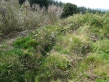
RCAHMS record no. HY20NW 20 is a mound 10 to 12 feet high mostly thought to be either the outwork to a broch (some instead go for a blockhouse underneath ) or an earlier promontory fort, the only dating evdence being broch-style pottery (finds lost), It lies ESE/WNW with an interior of the order 90' by 55'. The isthmus neck is blocked by a bank 10' wide and the same in height in which Raymond Lamb saw walling traces with erect slabs amongst the rubble as well as what is left of a much slighter outer bank and ditch. On the mound antiquarians thought there had been a substantial stone structure reduced to slight scattered remains that led them to hazard 12' thick walls consistent with a broch. Some large stones stood in situ, more so at the cliff's west side. The mound's slopes abound in walling traces and earthfast stones. A shell midden yielded those fragments of the coarse ware called broch-type. RCAHMS couldn't find the midden later, but given how confusing the site lies I would suggest that this is the midden later noted on the south side of the clifftop behind the supposed blockhouse. Much of the promontory contains wall traces and earthfast stones.
Directions - From Moaness pier follow the road straight up until you're nearing the reservoir at the start of the Rackwick Trail then turn right onto the road that starts parallel to Round Hill. Unless you own property here you will have to leave any transport behind when you reach the interpretation board, opposite which is a people gate, Just past Murra turn left. The road turns into a track as you approach Head. At Head turn left towards Braebister Burn then turn right and follow the fence. The brough lies between Braebister Burn and the steep-sided Yelting Geo. The footbridge you see is for folk taking the coastal walk from Moaness continuing to the Kame of Hoy, the silo drums upstream had been adapted as a fish hatchery. Along the mound is a diagonal line that brings to mind days of excavating with wheelbarrows. This a grassy path about a metre wide that goes all the way up and ends at the edge of the best preserved section. I'd love it to be an antique track there but suspect the way is much later and was used for plundering stones for work elsewhere. The mound definitely feels like two different sites, one upon another. The archaeology goes all the way up to the cliff edges, so watch your step - the day I was there 40mph winds buffeted me as I risked the photos but no way was I circling taking video, you'd die that way.
You may be viewing yesterday's version of this page. To see the most up to date information please register for a free account.
")
")
")
")
")
")
")
")
")
")
")
")
")
")
Do not use the above information on other web sites or publications without permission of the contributor.
Click here to see more info for this site
Nearby sites
Key: Red: member's photo, Blue: 3rd party photo, Yellow: other image, Green: no photo - please go there and take one, Grey: site destroyed
Download sites to:
KML (Google Earth)
GPX (GPS waypoints)
CSV (Garmin/Navman)
CSV (Excel)
To unlock full downloads you need to sign up as a Contributory Member. Otherwise downloads are limited to 50 sites.
Turn off the page maps and other distractions
Nearby sites listing. In the following links * = Image available
4.1km NE 36° Warebeth* Chambered Tomb (HY238085)
4.2km NNE 15° Broch of Breckness* Broch or Nuraghe (HY225093)
4.3km SE 134° Whiteglen Standing Stone Standing Stone (Menhir) (HY24350221)
4.4km ESE 122° Quoyness, Greenhill Broch* Broch or Nuraghe (HY25000284)
4.4km NNE 22° Leafea* Standing Stones (HY23060927)
4.7km NNE 21° Brockan* Ancient Village or Settlement (HY231096)
5.4km NE 39° Haley Hole Well (Brownstown) Holy Well or Sacred Spring (HY2477609314)
5.6km SSE 147° Dwarfie Stane* Rock Cut Tomb (HY24300043)
6.4km NE 53° Quoyelsh* Ancient Village or Settlement (HY265089)
8.1km NNE 25° Una* Artificial Mound (HY24841254)
8.1km E 82° Sower Castle* Ancient Village or Settlement (HY29400620)
8.5km NE 47° Howe Chambered Tomb* Chambered Tomb (HY276109)
8.5km NE 38° Deepdale Cottages* Standing Stones (HY267118)
8.6km NE 52° Cummi Howe* Broch or Nuraghe (HY282104)
8.7km NE 54° Corn Hillock* Cairn (HY28481015)
8.8km NE 41° Deepdale Stones* Standing Stone (Menhir) (HY272118)
9.0km ENE 58° The Cairns* Cairn (HY29050987)
9.5km NE 45° Diamond Cottage* Promontory Fort / Cliff Castle (HY28211176)
9.5km NE 46° Unstan* Chambered Cairn (HY28291172)
10.5km N 2° Brough of Bigging* Hillfort (HY219157)
10.5km NNE 21° Voy.* Ancient Village or Settlement (HY25351497)
10.8km NNE 25° Voy Crannogs* Crannog (HY261149)
11.0km NE 53° Standing Stones Hotel* Chambered Cairn (HY30251165)
11.1km NE 45° Possible large stone circle in Loch of Stenness Stone Circle (HY2933112934)
11.2km NE 45° Fairy Well (Stenness)* Holy Well or Sacred Spring (HY2943212982)
View more nearby sites and additional images


 We would like to know more about this location. Please feel free to add a brief description and any relevant information in your own language.
 Wir möchten mehr über diese Stätte erfahren. Bitte zögern Sie nicht, eine kurze Beschreibung und relevante Informationen in Deutsch hinzuzufügen.
 Nous aimerions en savoir encore un peu sur les lieux. S'il vous plaît n'hesitez pas à ajouter une courte description et tous les renseignements pertinents dans votre propre langue.
 Quisieramos informarnos un poco más de las lugares. No dude en añadir una breve descripción y otros datos relevantes en su propio idioma.