

<< Our Photo Pages >> Howe Chambered Tomb - Chambered Tomb in Scotland in Orkney
Submitted by drolaf on Saturday, 09 July 2022 Page Views: 439
Neolithic and Bronze AgeSite Name: Howe Chambered TombCountry: Scotland County: Orkney Type: Chambered Tomb
Nearest Town: Stromness
Map Ref: HY276109
Latitude: 58.979098N Longitude: 3.261158W
Condition:
| 5 | Perfect |
| 4 | Almost Perfect |
| 3 | Reasonable but with some damage |
| 2 | Ruined but still recognisable as an ancient site |
| 1 | Pretty much destroyed, possibly visible as crop marks |
| 0 | No data. |
| -1 | Completely destroyed |
| 5 | Superb |
| 4 | Good |
| 3 | Ordinary |
| 2 | Not Good |
| 1 | Awful |
| 0 | No data. |
| 5 | Can be driven to, probably with disabled access |
| 4 | Short walk on a footpath |
| 3 | Requiring a bit more of a walk |
| 2 | A long walk |
| 1 | In the middle of nowhere, a nightmare to find |
| 0 | No data. |
| 5 | co-ordinates taken by GPS or official recorded co-ordinates |
| 4 | co-ordinates scaled from a detailed map |
| 3 | co-ordinates scaled from a bad map |
| 2 | co-ordinates of the nearest village |
| 1 | co-ordinates of the nearest town |
| 0 | no data |
Internal Links:
External Links:
I have visited· I would like to visit
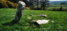
drolaf visited on 15th Jun 2022 - their rating: Cond: -1 Amb: 4 although the site is demolished, the ambience in terms of views is very good, NE over Unstan to Brodgar and the hills beyond at Staneyhill quarry and chambered tomb, and SW to the Hoy hills.
")
This means that the Bookan-Brodgar-Maes complex has visual links east to Harper Howe and west to the large passage grave at Howe, very near Unstan stalled tomb a kilometre NE, and the Deepdale standing stones a kilometre NW.
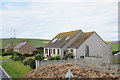
This site was fully excavated 1978 to 1982 deliberately in its entirety to destruction, revealing use from the Neolithic up to late Roman period and later. Before demolition it was still a conspicuous mound, 40m in diameter and 4.5m high. The site consisted of an Iron Age ring-fort overlain by a broch and a later Pictish settlement on the S side of the broch. A later Viking black glass linen-smoother was found. If excavation had stopped at preservation of the broch, the Neolithic site would never have been found, and this suggests that at least some other Neolithic sites lie beneath later buildings. Euan Mackie ascribed great importance to it in his 2002 report. David Lynn pointed out in 2004 that a decision to not level the Neolithic structures meant that later buildings all suffered from problems of subsidence. Possibly a respect for the past affected the better judgement of the later builders.
Information from-
https://canmore.org.uk/site/1731/the-howe
http://www.nessofbrodgar.co.uk/around-the-ness-howe/
Ballin-Smith, B. (ed) (1994) Howe: Four millennia of Orkney prehistory. Society of Antiquaries of Scotland.
https://orkneyjar.com/archaeology/dhl/papers/howe/index.html
You may be viewing yesterday's version of this page. To see the most up to date information please register for a free account.
")
")
Do not use the above information on other web sites or publications without permission of the contributor.
Nearby Images from Geograph Britain and Ireland:
©2013(licence)
©2023(licence)
©2013(licence)
©2018(licence)

©2015(licence)
The above images may not be of the site on this page, they are loaded from Geograph.
Please Submit an Image of this site or go out and take one for us!
Click here to see more info for this site
Nearby sites
Key: Red: member's photo, Blue: 3rd party photo, Yellow: other image, Green: no photo - please go there and take one, Grey: site destroyed
Download sites to:
KML (Google Earth)
GPX (GPS waypoints)
CSV (Garmin/Navman)
CSV (Excel)
To unlock full downloads you need to sign up as a Contributory Member. Otherwise downloads are limited to 50 sites.
Turn off the page maps and other distractions
Nearby sites listing. In the following links * = Image available
779m SE 129° Cummi Howe* Broch or Nuraghe (HY282104)
983m NNW 335° Deepdale Stones* Standing Stone (Menhir) (HY272118)
1.1km NE 34° Diamond Cottage* Promontory Fort / Cliff Castle (HY28211176)
1.1km NE 39° Unstan* Chambered Cairn (HY28291172)
1.2km SE 129° Corn Hillock* Cairn (HY28481015)
1.3km NW 314° Deepdale Cottages* Standing Stones (HY267118)
1.8km SE 124° The Cairns* Cairn (HY29050987)
2.3km SSW 208° Quoyelsh* Ancient Village or Settlement (HY265089)
2.7km NE 39° Possible large stone circle in Loch of Stenness Stone Circle (HY2933112934)
2.7km ENE 73° Standing Stones Hotel* Chambered Cairn (HY30251165)
2.8km NE 40° Fairy Well (Stenness)* Holy Well or Sacred Spring (HY2943212982)
2.9km NE 34° Salt Knowe* Round Barrow(s) (HY293133)
3.0km NE 36° South Knowe* Artificial Mound (HY29411328)
3.1km NE 36° Ring of Brodgar* Stone Circle (HY29451335)
3.1km NNE 24° Wasbister Disc Barrow* Round Barrow(s) (HY289137)
3.1km NNE 24° Dyke o'Sean* Ancient Village or Settlement (HY289137)
3.2km NE 39° Comet Stone (Orkney)* Standing Stone (Menhir) (HY2963413318)
3.2km NNE 24° Wasbister Burnt Mound* Artificial Mound (HY28961378)
3.2km NE 38° Fresh Knowe* Long Barrow (HY29601339)
3.2km WNW 300° Una* Artificial Mound (HY24841254)
3.2km NE 35° Plumcake Mound* Round Barrow(s) (HY295135)
3.2km WSW 240° Haley Hole Well (Brownstown) Holy Well or Sacred Spring (HY2477609314)
3.3km NNE 22° Bookan Cairns* Cairn (HY289139)
3.3km NE 51° Brodgar Farm Chambered Tomb Chambered Tomb (HY302129)
3.3km NE 54° Brodgar Farm Standing Stones* Standing Stones (HY303128)
View more nearby sites and additional images


 We would like to know more about this location. Please feel free to add a brief description and any relevant information in your own language.
 Wir möchten mehr über diese Stätte erfahren. Bitte zögern Sie nicht, eine kurze Beschreibung und relevante Informationen in Deutsch hinzuzufügen.
 Nous aimerions en savoir encore un peu sur les lieux. S'il vous plaît n'hesitez pas à ajouter une courte description et tous les renseignements pertinents dans votre propre langue.
 Quisieramos informarnos un poco más de las lugares. No dude en añadir una breve descripción y otros datos relevantes en su propio idioma.