<< Our Photo Pages >> Una - Artificial Mound in Scotland in Orkney
Submitted by howar on Wednesday, 17 June 2009 Page Views: 3840
Multi-periodSite Name: Una Alternative Name: Quholm (Burn of Una), Burn of UnaCountry: Scotland County: Orkney Type: Artificial Mound
Nearest Town: Stromness
Map Ref: HY24841254
Latitude: 58.993345N Longitude: 3.309714W
Condition:
| 5 | Perfect |
| 4 | Almost Perfect |
| 3 | Reasonable but with some damage |
| 2 | Ruined but still recognisable as an ancient site |
| 1 | Pretty much destroyed, possibly visible as crop marks |
| 0 | No data. |
| -1 | Completely destroyed |
| 5 | Superb |
| 4 | Good |
| 3 | Ordinary |
| 2 | Not Good |
| 1 | Awful |
| 0 | No data. |
| 5 | Can be driven to, probably with disabled access |
| 4 | Short walk on a footpath |
| 3 | Requiring a bit more of a walk |
| 2 | A long walk |
| 1 | In the middle of nowhere, a nightmare to find |
| 0 | No data. |
| 5 | co-ordinates taken by GPS or official recorded co-ordinates |
| 4 | co-ordinates scaled from a detailed map |
| 3 | co-ordinates scaled from a bad map |
| 2 | co-ordinates of the nearest village |
| 1 | co-ordinates of the nearest town |
| 0 | no data |
Internal Links:
External Links:
I have visited· I would like to visit
Trammejm would like to visit
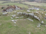
RCAHMS record no. HY21SW 3 is not to be confused with 2 burnt mounds of the same name much further downstream (fortunately the latter do not appear on the O.S. They are metre-high mounds outside the bend in Works road). Reached by the Cauldhame road outside Stromness, being the other side from Una, located where the fence comes to the south side of the stream. In the two-and-a-half metre high grassy mound you can still make out the circular tumulus this had been seen as in 1880 and the later 1.3m deep cut excavated therein (nothing is known of the excavation or any finds - perhaps locals looking for treaure as in St.Andrew's ??). The burn runs around its N side but as seen from the road there are signs that it may have gone around the other too (unless what is curving around there is a platform) and it presents the appearance of an islet in the stream - perhaps someone adapted a natural feature as from every direction I looked it seems simply such earth as the banks are composed of and there is suspicious terracing on it as if carved by water. Shortage of time means I did not go into the field. And the peedie burnt stones are on the unseen eastern slope. Though this has led to its classification as a burnt mound this doesn't ring true - perhaps it has been adapted to become a water-wound cinerary mound like those of Langa Dae in this parish.
You may be viewing yesterday's version of this page. To see the most up to date information please register for a free account.












These are just the first 25 photos of Una. If you log in with a free user account you will be able to see our entire collection.
Do not use the above information on other web sites or publications without permission of the contributor.
Click here to see more info for this site
Nearby sites
Key: Red: member's photo, Blue: 3rd party photo, Yellow: other image, Green: no photo - please go there and take one, Grey: site destroyed
Download sites to:
KML (Google Earth)
GPX (GPS waypoints)
CSV (Garmin/Navman)
CSV (Excel)
To unlock full downloads you need to sign up as a Contributory Member. Otherwise downloads are limited to 50 sites.
Turn off the page maps and other distractions
Nearby sites listing. In the following links * = Image available
2.0km ESE 111° Deepdale Cottages* Standing Stones (HY267118)
2.5km ESE 106° Deepdale Stones* Standing Stone (Menhir) (HY272118)
2.5km N 11° Voy.* Ancient Village or Settlement (HY25351497)
2.7km NNE 27° Voy Crannogs* Crannog (HY261149)
3.2km ESE 120° Howe Chambered Tomb* Chambered Tomb (HY276109)
3.2km S 180° Haley Hole Well (Brownstown) Holy Well or Sacred Spring (HY2477609314)
3.3km NE 39° Burroughston 2* Broch or Nuraghe (HY270151)
3.4km NE 40° Stackrue* Broch or Nuraghe (HY271151)
3.4km SSW 209° Brockan* Ancient Village or Settlement (HY231096)
3.4km ESE 102° Diamond Cottage* Promontory Fort / Cliff Castle (HY28211176)
3.5km NE 40° Stackrue-Lyking Mound* Misc. Earthwork (HY27121514)
3.5km NNE 14° Fiddlerhouse* Standing Stones (HY25771588)
3.5km ESE 102° Unstan* Chambered Cairn (HY28291172)
3.6km NNE 18° Via Mound* Round Cairn (HY26011598)
3.6km NNE 17° Stones of Via* Ancient Village or Settlement (HY260160)
3.7km NNE 15° Via Barrow* Round Barrow(s) (HY25841609)
3.7km SSW 207° Leafea* Standing Stones (HY23060927)
3.9km ENE 60° Skae Frue* Round Barrow(s) (HY28241440)
4.0km ENE 59° Ring of Bookan* Henge (HY283145)
4.0km ESE 121° Cummi Howe* Broch or Nuraghe (HY282104)
4.0km SW 215° Broch of Breckness* Broch or Nuraghe (HY225093)
4.0km SSE 154° Quoyelsh* Ancient Village or Settlement (HY265089)
4.1km ENE 66° Bookan* Chambered Tomb (HY286141)
4.1km NNW 338° South Seatter Round Barrow(s) (HY23391637)
4.1km ENE 64° The Brecks* Cairn (HY286143)
View more nearby sites and additional images


 We would like to know more about this location. Please feel free to add a brief description and any relevant information in your own language.
 Wir möchten mehr über diese Stätte erfahren. Bitte zögern Sie nicht, eine kurze Beschreibung und relevante Informationen in Deutsch hinzuzufügen.
 Nous aimerions en savoir encore un peu sur les lieux. S'il vous plaît n'hesitez pas à ajouter une courte description et tous les renseignements pertinents dans votre propre langue.
 Quisieramos informarnos un poco más de las lugares. No dude en añadir una breve descripción y otros datos relevantes en su propio idioma.