

<< Our Photo Pages >> Uragh SW - Stone Circle in Ireland (Republic of) in Co. Kerry
Submitted by Tom_Bullock on Sunday, 14 July 2002 Page Views: 9743
Neolithic and Bronze AgeSite Name: Uragh SWCountry: Ireland (Republic of) County: Co. Kerry Type: Stone Circle
Nearest Town: Kenmare Nearest Village: Tuosist
Map Ref: V8251363033
Discovery Map Number: D84
Latitude: 51.807777N Longitude: 9.704131W
Condition:
| 5 | Perfect |
| 4 | Almost Perfect |
| 3 | Reasonable but with some damage |
| 2 | Ruined but still recognisable as an ancient site |
| 1 | Pretty much destroyed, possibly visible as crop marks |
| 0 | No data. |
| -1 | Completely destroyed |
| 5 | Superb |
| 4 | Good |
| 3 | Ordinary |
| 2 | Not Good |
| 1 | Awful |
| 0 | No data. |
| 5 | Can be driven to, probably with disabled access |
| 4 | Short walk on a footpath |
| 3 | Requiring a bit more of a walk |
| 2 | A long walk |
| 1 | In the middle of nowhere, a nightmare to find |
| 0 | No data. |
| 5 | co-ordinates taken by GPS or official recorded co-ordinates |
| 4 | co-ordinates scaled from a detailed map |
| 3 | co-ordinates scaled from a bad map |
| 2 | co-ordinates of the nearest village |
| 1 | co-ordinates of the nearest town |
| 0 | no data |
Internal Links:
External Links:
I have visited· I would like to visit
tsstorey visited on 25th Sep 2015 - their rating: Access: 3 This circle is getting very overgrown with prickly gorse and tall grass. Some of the back stones were completely covered. I walked right through it and didn't notice it until I turned around. It would be a beautiful circle if it was cleaned out a bit.
kith visited on 1st Feb 2013 - their rating: Cond: 4 Amb: 4 Access: 3
Average ratings for this site from all visit loggers: Access: 3
")
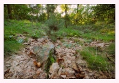
Circle diameter: 33 by 26 feet, Number of stones: 11
This circle is difficult to find, but is worth the visit. There is a boulder burial in the center. There are 2 brilliant quartz stones at the S, as well as one off center within the ring.
You may be viewing yesterday's version of this page. To see the most up to date information please register for a free account.
")
")
")
")
")
Do not use the above information on other web sites or publications without permission of the contributor.
Click here to see more info for this site
Nearby sites
Click here to view sites on an interactive map of the areaKey: Red: member's photo, Blue: 3rd party photo, Yellow: other image, Green: no photo - please go there and take one, Grey: site destroyed
Download sites to:
KML (Google Earth)
GPX (GPS waypoints)
CSV (Garmin/Navman)
CSV (Excel)
To unlock full downloads you need to sign up as a Contributory Member. Otherwise downloads are limited to 50 sites.
Turn off the page maps and other distractions
Nearby sites listing. In the following links * = Image available
726m NE 55° Uragh NE* Stone Circle (V8311763439)
1.2km NE 56° Uragh North* Stone Circle (V83526368)
2.1km W 272° Derrylough* Wedge Tomb (V80456315)
3.3km N 357° Tuosist* Stone Circle (V824663)
3.3km E 87° Maulagowna* Wedge Tomb (V85826311)
3.5km NW 305° Ormonds Island* Standing Stones (V79716512)
4.1km SW 224° Knockanoughanish* Wedge Tomb (V7956960174)
4.1km SW 236° Drombohilly Stone Circle* Stone Circle (V7901060792)
4.3km SW 233° Drombohilly Wedge Tomb* Wedge Tomb (V79016053)
4.7km WSW 237° Lehid* Standing Stone (Menhir) (V78506055)
5.1km ENE 72° Derrysallagh* Stone Row / Alignment (V874645)
5.3km SW 226° Cummers West* Stone Circle (V7859359484)
5.4km ENE 70° Derryvorahig* Stone Row / Alignment (V8763564745)
5.4km S 176° The Cave of the Scribing* Cave or Rock Shelter (V828576)
6.1km N 5° Lomanagh Holy Well* Holy Well or Sacred Spring
6.2km ENE 63° Dromroe* Stone Circle (V8810565708)
6.5km NNW 330° Derreenafoyle Standing Stones (V794688)
7.8km SW 226° Reenkilla* Stone Circle (V768577)
8.3km SSW 206° Clogherane* Standing Stones
8.7km SW 232° Cashelkeelty Standing Stones* Standing Stones (V75485784)
9.3km ESE 105° Tooreen bronze age copper mine* Ancient Mine, Quarry or other Industry
9.4km SW 233° Cashelkeelty E* Stone Circle (V74815757)
9.4km SW 233° Cashelkeelty Stone Row* Stone Row / Alignment
9.5km SW 234° Cashelkeelty W* Stone Circle
10.4km NW 323° Dromlusk* Standing Stone (Menhir)
View more nearby sites and additional images


 We would like to know more about this location. Please feel free to add a brief description and any relevant information in your own language.
 Wir möchten mehr über diese Stätte erfahren. Bitte zögern Sie nicht, eine kurze Beschreibung und relevante Informationen in Deutsch hinzuzufügen.
 Nous aimerions en savoir encore un peu sur les lieux. S'il vous plaît n'hesitez pas à ajouter une courte description et tous les renseignements pertinents dans votre propre langue.
 Quisieramos informarnos un poco más de las lugares. No dude en añadir una breve descripción y otros datos relevantes en su propio idioma.