


<< Our Photo Pages >> Clogherane - Standing Stones in Ireland (Republic of) in Co. Kerry
Submitted by frogcottage42 on Saturday, 25 September 2004 Page Views: 7838
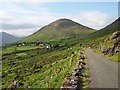
Neolithic and Bronze AgeSite Name: ClogheraneCountry: Ireland (Republic of) County: Co. Kerry Type: Standing Stones
Discovery Map Number: D84
Latitude: 51.741273N Longitude: 9.757332W
Condition:
| 5 | Perfect |
| 4 | Almost Perfect |
| 3 | Reasonable but with some damage |
| 2 | Ruined but still recognisable as an ancient site |
| 1 | Pretty much destroyed, possibly visible as crop marks |
| 0 | No data. |
| -1 | Completely destroyed |
| 5 | Superb |
| 4 | Good |
| 3 | Ordinary |
| 2 | Not Good |
| 1 | Awful |
| 0 | No data. |
| 5 | Can be driven to, probably with disabled access |
| 4 | Short walk on a footpath |
| 3 | Requiring a bit more of a walk |
| 2 | A long walk |
| 1 | In the middle of nowhere, a nightmare to find |
| 0 | No data. |
| 5 | co-ordinates taken by GPS or official recorded co-ordinates |
| 4 | co-ordinates scaled from a detailed map |
| 3 | co-ordinates scaled from a bad map |
| 2 | co-ordinates of the nearest village |
| 1 | co-ordinates of the nearest town |
| 0 | no data |
Internal Links:
External Links:
I have visited· I would like to visit
frogcottage42 has visited here
")
The taller stone is 2.6m high.
You may be viewing yesterday's version of this page. To see the most up to date information please register for a free account.
")
")
Do not use the above information on other web sites or publications without permission of the contributor.
Nearby Images from Geograph Britain and Ireland:
©2008(licence)
©2020(licence)
©2017(licence)
©2009(licence)
©2006(licence)
The above images may not be of the site on this page, they are loaded from Geograph.
Please Submit an Image of this site or go out and take one for us!
Click here to see more info for this site
Nearby sites
Click here to view sites on an interactive map of the areaKey: Red: member's photo, Blue: 3rd party photo, Yellow: other image, Green: no photo - please go there and take one, Grey: site destroyed
Download sites to:
KML (Google Earth)
GPX (GPS waypoints)
CSV (Garmin/Navman)
CSV (Excel)
To unlock full downloads you need to sign up as a Contributory Member. Otherwise downloads are limited to 50 sites.
Turn off the page maps and other distractions
Nearby sites listing. In the following links * = Image available
2.7km NW 315° Reenkilla* Stone Circle (V768577)
3.2km W 263° Shronebirrane* Stone Circle (V7542355403)
3.8km N 358° Cummers West* Stone Circle (V7859359484)
3.8km WNW 302° Cashelkeelty Standing Stones* Standing Stones (V75485784)
4.0km WSW 251° Deelis Hut Site* Ancient Village or Settlement
4.1km SW 218° Glanmore* Standing Stones (V76065251)
4.3km WNW 294° Cashelkeelty Stone Row* Stone Row / Alignment
4.3km WNW 294° Cashelkeelty E* Stone Circle (V74815757)
4.3km WNW 294° Cashelkeelty W* Stone Circle
4.5km ENE 64° The Cave of the Scribing* Cave or Rock Shelter (V828576)
4.5km N 10° Knockanoughanish* Wedge Tomb (V7956960174)
4.6km SE 137° Kilcaskan* Stone Row / Alignment (V817523)
4.6km WSW 249° Cummeengeera enclosure and standing stone* Standing Stone (Menhir)
4.8km WSW 249° Rabhach's Cave - Cummeengeera Glen* Natural Stone / Erratic / Other Natural Feature
4.8km N 3° Drombohilly Wedge Tomb* Wedge Tomb (V79016053)
4.8km N 357° Lehid* Standing Stone (Menhir) (V78506055)
4.9km SE 139° Kilcaskin* Standing Stones (V81805200)
5.1km N 2° Drombohilly Stone Circle* Stone Circle (V7901060792)
5.9km SSE 157° Dromgarvan Stone Circle
6.5km SE 144° Drumlave* Stone Row / Alignment (V82365040)
6.8km W 275° Ardgroom Outward NE* Stone Circle (V71885646)
7.1km SE 124° Ballynahowen Wedge Tomb* Wedge Tomb (V8440851580)
7.4km W 267° Ardgroom Outward NE pair Standing Stones (V71295556)
7.6km NNE 12° Derrylough* Wedge Tomb (V80456315)
7.8km W 266° Ardgroom Stone Circle* Stone Circle (V7087255339)
View more nearby sites and additional images


 We would like to know more about this location. Please feel free to add a brief description and any relevant information in your own language.
 Wir möchten mehr über diese Stätte erfahren. Bitte zögern Sie nicht, eine kurze Beschreibung und relevante Informationen in Deutsch hinzuzufügen.
 Nous aimerions en savoir encore un peu sur les lieux. S'il vous plaît n'hesitez pas à ajouter une courte description et tous les renseignements pertinents dans votre propre langue.
 Quisieramos informarnos un poco más de las lugares. No dude en añadir una breve descripción y otros datos relevantes en su propio idioma.