<< Our Photo Pages >> Lydford Anglo Saxon Defences - Misc. Earthwork in England in Devon

Submitted by JohnE on Monday, 13 May 2024  Page Views: 181

Early Medieval (Dark Age)Site Name: Lydford Anglo Saxon Defences
Country: England County: Devon Type: Misc. Earthwork
Nearest Town: Okehampton  Nearest Village: Lydford
Map Ref: SX51088487
Latitude: 50.644435N  Longitude: 4.107622W
Condition:
5Perfect
4Almost Perfect
3Reasonable but with some damage
2Ruined but still recognisable as an ancient site
1Pretty much destroyed, possibly visible as crop marks
0No data.
-1Completely destroyed
3 Ambience:
5Superb
4Good
3Ordinary
2Not Good
1Awful
0No data.
4 Access:
5Can be driven to, probably with disabled access
4Short walk on a footpath
3Requiring a bit more of a walk
2A long walk
1In the middle of nowhere, a nightmare to find
0No data.
4 Accuracy:
5co-ordinates taken by GPS or official recorded co-ordinates
4co-ordinates scaled from a detailed map
3co-ordinates scaled from a bad map
2co-ordinates of the nearest village
1co-ordinates of the nearest town
0no data
4

Internal Links:
External Links:

Lydford Anglo Saxon Defences
Lydford Anglo Saxon Defences submitted by JohnE : Photo 5: Looking south east. (Taken 9 May 2024.) (Vote or comment on this photo)
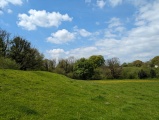
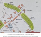
Lydford is a village between Okehampton and Tavistock in Devon. In the 9th century it is documented as one of four important towns or burhs in Devon. The surviving defensive earthworks shown in the photos are at the north east end of the village, but it is likely that the defences once surrounded the whole of the Saxon town.

Is streets were laid out in a grid pattern still evident in the village today, where modern hedges and footpaths fossilise the courses of earlier streets.

The grid reference given is the intersection of the earthworks and the road through the village.
You may be viewing yesterday's version of this page. To see the most up to date information please register for a free account.


Lydford Anglo Saxon Defences
Lydford Anglo Saxon Defences submitted by JohnE : Memorial erected by the WI in 1990 referring to the defeat of the Danish army at Lydford in 997. Located at the south end of the village, opposite the church. (Taken 9 May 2024.) (Vote or comment on this photo)

Lydford Anglo Saxon Defences
Lydford Anglo Saxon Defences submitted by JohnE : Photo 8: Looking north west. (Taken 9 May 2024.) (Vote or comment on this photo)

Lydford Anglo Saxon Defences
Lydford Anglo Saxon Defences submitted by JohnE : Photo 7: Looking south east. (Taken 9 May 2024.) (Vote or comment on this photo)

Lydford Anglo Saxon Defences
Lydford Anglo Saxon Defences submitted by JohnE : Photo 6: Entrance gate. (Taken 9 May 2024.) (Vote or comment on this photo)

Lydford Anglo Saxon Defences
Lydford Anglo Saxon Defences submitted by JohnE : Photo 4: Looking north west. (Taken 9 May 2024.)

Lydford Anglo Saxon Defences
Lydford Anglo Saxon Defences submitted by JohnE : Photo 3: Looking north west. (Taken 9 May 2024.)

Lydford Anglo Saxon Defences
Lydford Anglo Saxon Defences submitted by JohnE : Photo 2: Entrance gate. (Taken 9 May 2024.)

Lydford Anglo Saxon Defences
Lydford Anglo Saxon Defences submitted by JohnE : Key to photo locations.

Lydford Anglo Saxon Defences
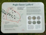
Lydford Anglo Saxon Defences submitted by JohnE : Photo1: The information board. (Taken 9 May 2024.)

Do not use the above information on other web sites or publications without permission of the contributor.
Click here to see more info for this site

Nearby sites

Click here to view sites on an interactive OS map

Key: Red: member's photo, Blue: 3rd party photo, Yellow: other image, Green: no photo - please go there and take one, Grey: site destroyed

Download sites to:
KML (Google Earth)
GPX (GPS waypoints)
CSV (Garmin/Navman)
CSV (Excel)

To unlock full downloads you need to sign up as a Contributory Member. Otherwise downloads are limited to 50 sites.


Turn off the page maps and other distractions

Nearby sites listing. In the following links * = Image available
 2.2km ESE 121° White Hill South* Ring Cairn (SX5294283680)
 2.3km SSE 150° Ring of Bells* Ring Cairn (SX5214082873)
 2.6km ESE 109° White Hill North Cairn Field Ring Cairn (SX53528395)
 2.7km ESE 103° White Hill North East* Cairn (SX5371384190)
 3.1km NNW 328° Burley Wood Hillfort Hillfort (SX49548754)
 3.3km E 89° Doe Tor* Cist (SX54388485)
 3.6km ESE 122° Nattor Down 5 Cairn (SX54098286)
 3.8km NE 46° Great Nodden* Cist (SX5387487416)
 3.9km ESE 111° Ger Tor Cairn (SX54658338)
 4.1km NE 49° Little Links Tor* Stone Row / Alignment (SX5428587463)
 4.2km ENE 65° Great Links Tor Cairn* Cairn (SX5491686496)
 4.2km SSW 194° Gibbett Hill Ring Cairn (SX49958084)
 4.3km N 360° Bridestowe Holy Well Holy Well or Sacred Spring (SX512892)
 4.5km SW 219° North Brentor Well* Holy Well or Sacred Spring (SX4813881440)
 5.1km SE 132° Standon Hill Cairn Cairn (SX5473781373)
 5.2km NE 38° Sourton Tors Ring Cairns* Ring Cairn (SX5441888858)
 5.4km WNW 282° Lewtrenchard Holy Well* Holy Well or Sacred Spring (SX458861)
 5.8km NE 36° Sourton Tors Cairn* Cairn (SX5460389438)
 5.9km NE 42° Corn Ridge Stone Ring Cairn Circle* Ring Cairn (SX5513889153)
 5.9km NE 42° Cornridge SE* Stone Circle (SX5517589119)
 5.9km NNE 21° Sourton Green Saxon Cross* Ancient Cross (SX534903)
 5.9km NE 36° Sourton Tors Stone Circle* Stone Circle (SX54688958)
 5.9km NE 42° Corn Ridge Rock* Ring Cairn (SX5521989145)
 6.0km SW 220° Brent Tor* Hillfort (SX4709780392)
 6.0km NE 43° Branscombe's Loaf* Ring Cairn (SX55318912)
View more nearby sites and additional images

<< Munkegård Skåltegn

Mangawhai Heads North Pa >>

Please add your thoughts on this site

Prehistoric Settlements

Prehistoric Settlements

Sponsors

Auto-Translation (Google)

Translate from English into:

"Lydford Anglo Saxon Defences" | Login/Create an Account | 4 News and Comments
  
Go back to top of page    Comments are owned by the poster. We aren't responsible for their content.
Re: Lydford Anglo Saxon Defences by Hatty on Friday, 17 May 2024
(User Info | Send a Message)
The earliest reference to the 'Burghal Hidage', a defensive network of 33 towns or burhs in southern England set up by Alfred the Great to save the townsfolk from Viking attacks as the story has it, is in a Tudor manuscript of 1562,. Turns out the towns were all Roman foundations or former Iron Age hill-forts which suggests Lydford predates the Saxon era.

William Crossing said he couldn't find sections of the ancient track and neither could I (even without the infamous Dartmoor mist). There doesn't seem to be much info though lich or lych supposedly describes a so-called corpse road. According to Crossing 'lynch' meant a track or rough road, usually a track that was lower than the ground on each side of it. A sunken path or holloway generally defines a track worn down by regular use over centuries, if not millenia, and it stands to reason such routes could be used for different purposes, perhaps including carrying a coffin.
[ Reply to This ]
    Re: Lydford Anglo Saxon Defences by JohnE on Monday, 20 May 2024
    (User Info | Send a Message)
    Hatty - Because there is the possibility that this site has an alternative story, I'm suggesting that it is renamed 'Lydford Earthworks' (although there are other earthworks in the village). This would have to be done by an editor though. What do you think?
    [ Reply to This ]

Re: Lydford Anglo Saxon Defences by Hatty on Wednesday, 15 May 2024
(User Info | Send a Message)
The earthworks are not invariably 'defensive'. It seems reasonable to assume a connection between the dykes and an ancient route, at some point (by Victorian antiquarians?) named the Lych Way. William Crossing, in his book 'Guide To Dartmoor', noted the trackway was marked in places by menhirs.
The Lyd, a small stream, is crossed by the Ridgeway aka Michael Line north of Lydford Gorge, perhaps where the current footbridge is. Lyd may be cognate with Lud or Lugh, and Lugh has been equated with Hermes/ Michael, patron of long distance travel, trade and, er, thieves. In medieval times Lydford, which was the admin centre for the tin mining trade on Dartmoor, had a court at the now infamous Lydford Castle (prison) dispensing 'Lydford Justice' - where the punishment came before the trial.
[ Reply to This ]
    Re: Lydford Anglo Saxon Defences by JohnE on Thursday, 16 May 2024
    (User Info | Send a Message)
    Thank you for your thoughts and interpretation on this. The choice of title is based on English Heritage's interpretation of the site and their terminology, and Historic England's official schedule listing. EH produced a research document (SAM Number: Devon 392) which, amongst other things, is in agreement with the existence of a defended Saxon burh, the town being included in the Burghal Hidage.

    But of course, one never be 100% certain!

    I have walked the route of the Lych Way between Bellever and Lydford couple of times and it is well worth doing.
    [ Reply to This ]

Your Name: Anonymous [ Register Now ]
Subject:


Add your comment or contribution to this page. Spam or offensive posts are deleted immediately, don't even bother

<<< What is five plus one as a number? (Please type the answer to this question in the little box on the left)
You can also embed videos and other things. For Youtube please copy and paste the 'embed code'.
For Google Street View please include Street View in the text.
Create a web link like this: <a href="https://www.megalithic.co.uk">This is a link</a>  

Allowed HTML is:
<p> <b> <i> <a> <img> <em> <br> <strong> <blockquote> <tt> <li> <ol> <ul> <object> <param> <embed> <iframe>

We would like to know more about this location. Please feel free to add a brief description and any relevant information in your own language.
Wir möchten mehr über diese Stätte erfahren. Bitte zögern Sie nicht, eine kurze Beschreibung und relevante Informationen in Deutsch hinzuzufügen.
Nous aimerions en savoir encore un peu sur les lieux. S'il vous plaît n'hesitez pas à ajouter une courte description et tous les renseignements pertinents dans votre propre langue.
Quisieramos informarnos un poco más de las lugares. No dude en añadir una breve descripción y otros datos relevantes en su propio idioma.