

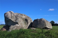

<< Text Pages >> Easdon Hill - Ring Cairn in England in Devon
Submitted by Anne T on Thursday, 27 October 2016 Page Views: 1775
Neolithic and Bronze AgeSite Name: Easdon HillCountry: England
NOTE: This site is 0.4 km away from the location you searched for.
County: Devon Type: Ring Cairn
Nearest Town: Moretonhampstead Nearest Village: Manaton / North Bovey
Map Ref: SX73358231
Latitude: 50.626696N Longitude: 3.791948W
Condition:
| 5 | Perfect |
| 4 | Almost Perfect |
| 3 | Reasonable but with some damage |
| 2 | Ruined but still recognisable as an ancient site |
| 1 | Pretty much destroyed, possibly visible as crop marks |
| 0 | No data. |
| -1 | Completely destroyed |
| 5 | Superb |
| 4 | Good |
| 3 | Ordinary |
| 2 | Not Good |
| 1 | Awful |
| 0 | No data. |
| 5 | Can be driven to, probably with disabled access |
| 4 | Short walk on a footpath |
| 3 | Requiring a bit more of a walk |
| 2 | A long walk |
| 1 | In the middle of nowhere, a nightmare to find |
| 0 | No data. |
| 5 | co-ordinates taken by GPS or official recorded co-ordinates |
| 4 | co-ordinates scaled from a detailed map |
| 3 | co-ordinates scaled from a bad map |
| 2 | co-ordinates of the nearest village |
| 1 | co-ordinates of the nearest town |
| 0 | no data |
Be the first person to rate this site - see the 'Contribute!' box in the right hand menu.
Internal Links:


External Links:


Ring Cairn in Devon
Information about the Easdon Hill Stone Ring Cairn Circle in the parish of Manaton comes from the Prehistoric Dartmoor Walks (PDW) website. Their notes tell us this is "a cairn with a large centrally placed rock which is possibly the capstone of a kist. Robbers have excavated around and about this giving a rock strewn central hollow to the cairn. There is no encircling ditch. The capstone is approximately square. Touching its base at the east is a triangular shaped orthostat. The cairn is situated on the very summit of a hill."
The PDW web page gives links to further information on Pastscape, Monument Number 445630, which adds that this is "is not a hut circle but a cairn which has been robbed, leaving an excavated hollow centre 6 metres in diameter and 0.9 metres deep."
The Devon & Dartmoor HER number MDV8767 dates both the ring cairn and cist from the Early Neolithic to the Late Bronze Age (4000BC to 701BC). This web page also tells us that the barrow is apparently incorporated into a reave. It is not scheduled ancient monument.
Note: Have you visited this site? Do you have any photographs, images or further information you can add?
You may be viewing yesterday's version of this page. To see the most up to date information please register for a free account.
Do not use the above information on other web sites or publications without permission of the contributor.
Nearby Images from Geograph Britain and Ireland:

©2015(licence)

©2011(licence)

©2005(licence)
©2018(licence)
©2018(licence)
The above images may not be of the site on this page, they are loaded from Geograph.
Please Submit an Image of this site or go out and take one for us!
Click here to see more info for this site
Log in or create a free account to see nearby ancient sites our visitors rate highly
All Nearby sites
 Click here to view sites on an interactive OS map
Download sites to:
KML (Google Earth)
GPX (GPS waypoints)
CSV (Garmin/Navman)
CSV (Excel)
To unlock full downloads you need to sign up as a Society Member. Otherwise downloads are limited to 50 sites.
Turn off the page maps and other distractions
Nearby sites listing. In the following links * = Image available
1.7km NNE 21° North Bovey* Ancient Cross (SX7399083879)
2.0km SSE 157° Bowerman's Nose* Rock Outcrop (SX74108046)
2.2km NW 325° Hele Cross* Ancient Cross (SX7213384164)
2.4km WNW 286° Shapley Round Ancient Village or Settlement (SX71038304)
2.6km NNE 20° Horspit Cross* Ancient Cross (SX7430684741)
2.8km NW 311° Beetor Cross* Ancient Cross (SX7129584187)
2.8km E 87° Hunter's Tor Fort* Hillfort (SX7616482412)
2.8km NW 313° Watching Place Waymarker* Marker Stone (SX7130484288)
2.9km SW 224° Berry Pound Ancient Village or Settlement (SX713803)
2.9km SW 219° Hamel Down row* Stone Row / Alignment (SX71488010)
3.1km WSW 247° Grimslake Cist* Cairn (SX7041881165)
3.3km WSW 258° Hookney Down Settlement Ancient Village or Settlement (SX70128173)
3.3km WNW 287° Leeper Cross* Ancient Cross (SX7022083325)
3.5km SSE 163° Hound Tor Enclosure* Causewayed Enclosure (SX74307897)
3.5km WSW 239° Hamel Down Platform Cairn (North)* Cairn (SX70318057)
3.6km WSW 245° Grimspound* Ancient Village or Settlement (SX70078090)
3.6km WSW 252° Hookney Tor Cairn* Cairn (SX6990281310)
3.6km SSE 167° Hound Tor Ring Cairn* Ring Cairn (SX7409778770)
3.7km WNW 282° Challacombe Cross Settlement* Ancient Village or Settlement (SX69788313)
3.7km SW 232° Hamel Down Cross* Ancient Cross (SX70428011)
3.7km SW 228° Broad Barrow (Hamel Down)* Round Barrow(s) (SX70577990)
3.7km ENE 68° Sanduck Cross* Ancient Cross (SX7681983610)
3.7km SSE 159° Hound Tor Deserted Medieval Village* Ancient Village or Settlement (SX74627878)
3.9km E 89° South Harton Cross* Ancient Cross (SX7724982273)
3.9km SW 224° Single Barrow (Hamel Down)* Round Barrow(s) (SX70577953)
View more nearby sites and additional images


 We would like to know more about this location. Please feel free to add a brief description and any relevant information in your own language.
 Wir möchten mehr über diese Stätte erfahren. Bitte zögern Sie nicht, eine kurze Beschreibung und relevante Informationen in Deutsch hinzuzufügen.
 Nous aimerions en savoir encore un peu sur les lieux. S'il vous plaît n'hesitez pas à ajouter une courte description et tous les renseignements pertinents dans votre propre langue.
 Quisieramos informarnos un poco más de las lugares. No dude en añadir una breve descripción y otros datos relevantes en su propio idioma.