<< Our Photo Pages >> Broad Barrow (Hamel Down) - Round Barrow(s) in England in Devon
Submitted by AngieLake on Sunday, 22 April 2007 Page Views: 7723
Neolithic and Bronze AgeSite Name: Broad Barrow (Hamel Down) Alternative Name: Hamel Down Barrow cemetery (Broad Barrow); Grinsell Manaton 10; Turner A46Country: England County: Devon Type: Round Barrow(s)
Nearest Town: Ashburton Nearest Village: Widecombe in the Moor
Map Ref: SX70577990
Latitude: 50.604423N Longitude: 3.83039W
Condition:
| 5 | Perfect |
| 4 | Almost Perfect |
| 3 | Reasonable but with some damage |
| 2 | Ruined but still recognisable as an ancient site |
| 1 | Pretty much destroyed, possibly visible as crop marks |
| 0 | No data. |
| -1 | Completely destroyed |
| 5 | Superb |
| 4 | Good |
| 3 | Ordinary |
| 2 | Not Good |
| 1 | Awful |
| 0 | No data. |
| 5 | Can be driven to, probably with disabled access |
| 4 | Short walk on a footpath |
| 3 | Requiring a bit more of a walk |
| 2 | A long walk |
| 1 | In the middle of nowhere, a nightmare to find |
| 0 | No data. |
| 5 | co-ordinates taken by GPS or official recorded co-ordinates |
| 4 | co-ordinates scaled from a detailed map |
| 3 | co-ordinates scaled from a bad map |
| 2 | co-ordinates of the nearest village |
| 1 | co-ordinates of the nearest town |
| 0 | no data |
Internal Links:
External Links:
I have visited· I would like to visit
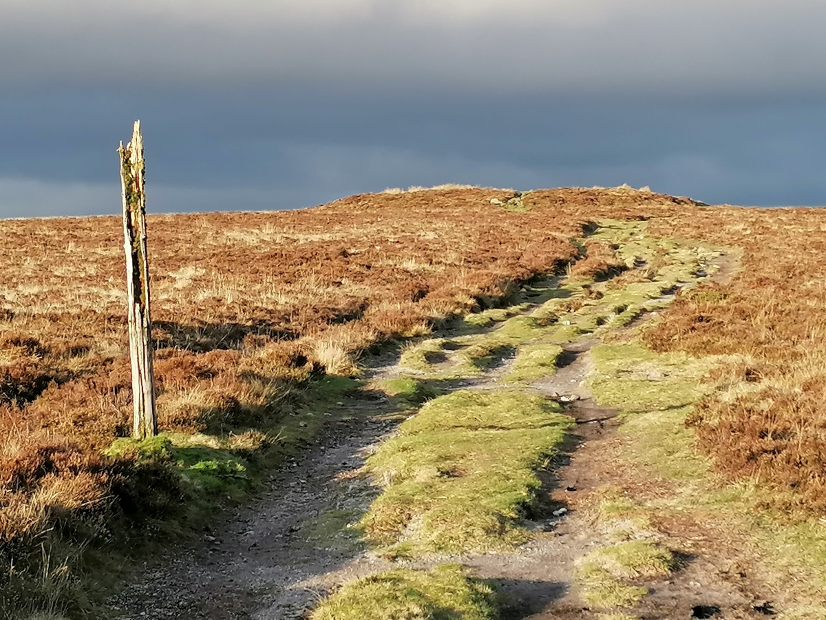
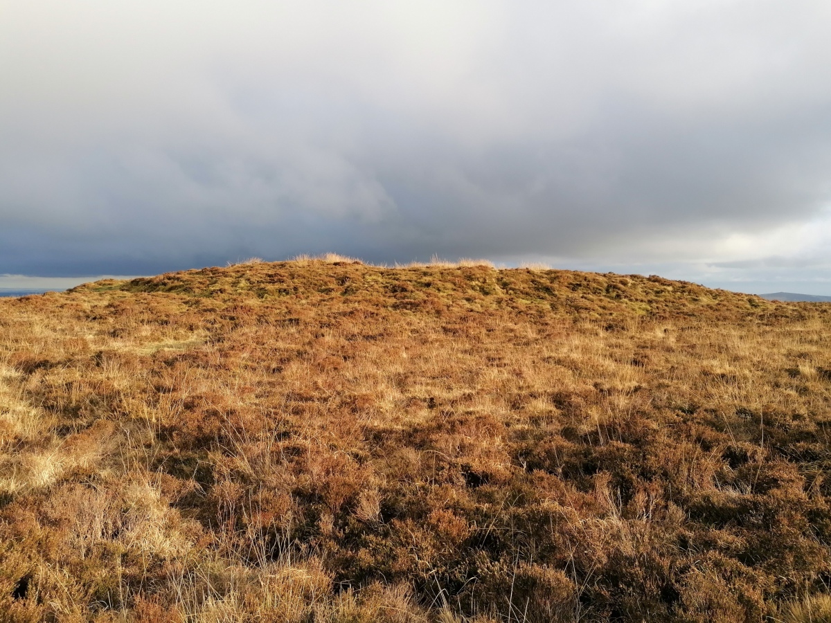
TheCaptain visited on 6th Dec 2022 - their rating: Cond: 3 Amb: 4 Access: 3 Walking on to the south, there is an obvious large cairn know as Broad Barrow atop the highest point of the down at 532m. This is one of the largest cairns on Dartmoor, but mostly an earthen construction, unlike many of the others. In its southern edge is an excavated stone structure, whether the remains of an old chamber or a more modern construction I do not know. In the central area on top is what looks like a grave, with a dug stony area and a "headstone", put here by the Duke of Somerset as a boundary marker in 1854.
AngieLake heidavey have visited here

Butler says it is one of the largest barrows on Dartmoor, only rivalled in size by one of the Three Barrows on Ugborough Moor.
Butler also mentions the stone marker. Apparently these 'Duke' stones were placed on five of the Hamel Down barrows to mark the boundary of Natsworthy Manor (owner in 19th century was Duke of Somerset).
The barrow was dug into some time before 1872 but is so huge that the central hollow and trench around the southern edge have not greatly disfigured its appearance. (Butler).
I found that the marker stone aligned at 120 degrees with the prominent outcrop of Haytor.
Update August 2019: This barrow is featured on Prehistoric Dartmoor Walks (PDW) - see their entry for the Broad Barrow Stone Ring Cairn Circle. It is also recorded as Pastscape Monument No. 445043 and scheduled as part of Historic England List ID 1003295 (Five barrows on Hamel Down). The Devon & Dartmoor HER also includes an entry: MDV20787 (Cairn south-east of Hameldown Cross).
You may be viewing yesterday's version of this page. To see the most up to date information please register for a free account.


Do not use the above information on other web sites or publications without permission of the contributor.
Click here to see more info for this site
Nearby sites
Key: Red: member's photo, Blue: 3rd party photo, Yellow: other image, Green: no photo - please go there and take one, Grey: site destroyed
Download sites to:
KML (Google Earth)
GPX (GPS waypoints)
CSV (Garmin/Navman)
CSV (Excel)
To unlock full downloads you need to sign up as a Contributory Member. Otherwise downloads are limited to 50 sites.
Turn off the page maps and other distractions
Nearby sites listing. In the following links * = Image available
258m NW 323° Hamel Down Cross* Ancient Cross (SX70428011)
370m S 179° Single Barrow (Hamel Down)* Round Barrow(s) (SX70577953)
401m S 174° Hamel Down* Barrow Cemetery (SX706795)
694m S 172° Two Barrows (Hamel Down)* Round Barrow(s) (SX70657921)
718m NNW 337° Hamel Down Platform Cairn (North)* Cairn (SX70318057)
817m S 171° Blackaton Down north (Hamel Down)* Cairn (SX70687909)
831m ENE 60° Berry Pound Ancient Village or Settlement (SX713803)
874m SSE 168° Blackaton Down south (Hamel Down)* Cairn (SX70737904)
929m ENE 76° Hamel Down row* Stone Row / Alignment (SX71488010)
1.0km SSE 164° Hamel Down Beacon cairn* Cairn (SX70837891)
1.1km NNW 332° Grimspound* Ancient Village or Settlement (SX70078090)
1.3km N 352° Grimslake Cist* Cairn (SX7041881165)
1.6km NNW 333° Hookney Tor Cairn* Cairn (SX6990281310)
1.6km SSE 163° Hamel Down Cairn and Cist* Cairn (SX7100878345)
1.7km WNW 297° Challacombe Down Standing Stone* Standing Stone (Menhir) (SX69028072)
1.8km WNW 299° Challacombe rows* Multiple Stone Rows / Avenue (SX68988082)
1.9km WNW 299° Challacombe Down Cairn Circle* Cairn (SX68968083)
2.4km NNW 331° Shapley Common Ancient Village or Settlement (SX69428206)
2.6km NW 312° Birch Tor Cairn* Cairn (SX6868681654)
2.9km W 264° Soussons Down Cairns* Barrow Cemetery (SX6770079671)
2.9km ESE 124° Chinkwell Tor Cairn* Cairn (SX7293078250)
2.9km W 270° Soussons Down Stone Row Multiple Stone Rows / Avenue (SX6767079980)
3.1km NW 316° Bush Down Settlement* Ancient Village or Settlement (SX6849282173)
3.1km WNW 302° Bennet's Cross* Ancient Cross (SX68008162)
3.3km WSW 247° Soussons Common* Stone Circle (SX6751178692)
View more nearby sites and additional images


 We would like to know more about this location. Please feel free to add a brief description and any relevant information in your own language.
 Wir möchten mehr über diese Stätte erfahren. Bitte zögern Sie nicht, eine kurze Beschreibung und relevante Informationen in Deutsch hinzuzufügen.
 Nous aimerions en savoir encore un peu sur les lieux. S'il vous plaît n'hesitez pas à ajouter une courte description et tous les renseignements pertinents dans votre propre langue.
 Quisieramos informarnos un poco más de las lugares. No dude en añadir una breve descripción y otros datos relevantes en su propio idioma.