 with our Megalithic Portal iPhone app")

Contributory members are able to log private notes and comments about each site
Sites TheCaptain has logged. View this log as a table or view the most recent logs from everyone
Treen standing stone A
Trip No.216 Entry No.46 Date Added: 9th Jul 2026
Site Type: Standing Stone (Menhir)
Country: England (Cornwall)
Visited: Yes on 15th Jun 2026. My rating: Condition 3 Ambience 3 Access 4
")
Treen standing stone A submitted by TheCaptain on 9th Jul 2026. Stone standing in a field near Treen, by the path down towards Penberth Cove. It is possibly just a cattle scratching post, but it seems very old and has been firmly retained in the ground with a lot of packing stones.
(View photo, vote or add a comment)
Log Text: Park at Treen, then walk down towards Penberth Cove, and after passing through the first field wall, there is a small stone standing in the field. It is possibly just a cattle scratching post, but it seems very old and has been firmly retained in the ground with a lot of packing stones. Like many of the stones around this part of the coast, it could be an ancient stone.
Twelve men's moor cairn and cist
Trip No.216 Entry No.45 Date Added: 7th Jul 2026
Site Type: Cist
Country: England (Cornwall)
Visited: Yes on 16th Jun 2026. My rating: Condition 4 Ambience 3 Access 4
")
Twelve men's moor cairn and cist submitted by Bladup on 15th Apr 2013. Twelve men's moor cairn and cist.
(View photo, vote or add a comment)
Log Text: Heading on northeast I get to the marked cairn with cist. This is quite interesting to see as it looks like it is in two halves, one of them complete and covered, while the other half has been removed to show the cist and the stone construction of the cairn. I wouldn't be surprised if there were several more of these out here. I now head back to the car along the track, and see a cuckoo flying across to the north. Brilliant. Time to get out of my wet muddy boots and head back to Bristol, thankfully an easy journey this time.
Trewortha Cairns
Trip No.216 Entry No.44 Date Added: 7th Jul 2026
Site Type: Barrow Cemetery
Country: England (Cornwall)
Visited: Yes on 16th Jun 2026. My rating: Condition 3 Ambience 3 Access 3
")
Trewortha Cairns submitted by dooclay on 23rd Oct 2022. Site in England
(View photo, vote or add a comment)
Log Text: With the weather getting worse, I now head on northwards and back towards the car passing the "mound" marked on the map (a cairn?) to the Trewortha Cairns which form a sort of line alongside the southern edge of the trackway to Trewortha Farm. I looked at about four of them before deciding that there are too many to look at closely and photograph each of them in this weather. Some are not much more than a grass and stone lump covered with ferns, but one or two are quite big stone structures with some kind of internal features.
Trewortha cairn and cist NE
Trip No.216 Entry No.43 Date Added: 6th Jul 2026
Site Type: Cairn
Country: England (Cornwall)
Visited: Yes on 16th Jun 2026. My rating: Condition 3 Ambience 4 Access 3
")
Trewortha cairn and cist NE submitted by TheCaptain on 6th Jul 2026. Less distinct than its neighbour within its surrounding of ferns and bushes. Just a couple of kerbstones stand proud, but there is almost certainly a cist within and might tidy up quite nicely.
(View photo, vote or add a comment)
Log Text: Once I have had my fill of the main event, I head to the northeast to find its neighbour, which is much less distinct within its surrounding of ferns and bushes. Just a couple of kerbstones stand proud, otherwise it looks not much more than a round stone cairn, but there is almost certainly a cist within and might tidy up quite nicely.
Trewortha Kerb cairn and cist
Trip No.216 Entry No.42 Date Added: 6th Jul 2026
Site Type: Chambered Cairn
Country: England (Cornwall)
Visited: Yes on 16th Jun 2026. My rating: Condition 5 Ambience 4 Access 3
")
Trewortha Kerb cairn and cist submitted by Bladup on 15th Apr 2013. Trewortha Kerb cairn and cist
(View photo, vote or add a comment)
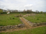
Log Text: Back down to the south from Kilmar Tor and find the old quarry railway, with its amazing lines of granite sleepers, and follow this west and around the end of Kilmar tor to the north until it ends, from where I can head down to the northwest towards Trewortha farm, stopping to have my pasty lunch at a convenient block to sit on. There is a lot of shooting going on over at the farm, and the sounds it makes echoing off the newly denuded Smallacomb Tor is incredible, each shot making about 5 seconds of whoossh noises as the echoes move around, and then more from Kilmar tor behind. Unfortunately the clouds and fog are getting worse, and it is now drizzling with rain showers coming over, so I decide to cut the planned walk short. I drop down and find the Trewortha Kerb cairn and cist easily, even in the mist. Its truly a fabulous monument, with its cist within a complete circle of standing stones, much taller than I was expecting. It certainly is the best one of these I have seen, but looks like a few of the stones are starting to lean over and perhaps in danger of collapse, maybe aided by cattle leaning on them.
Kilmar Tor.
Trip No.216 Entry No.41 Date Added: 6th Jul 2026
Site Type: Rock Outcrop
Country: England (Cornwall)
Visited: Yes on 16th Jun 2026. My rating: Condition 4 Ambience 5 Access 3
")
Kilmar tor. submitted by Bladup on 21st Jul 2015. Kilmar tor.
(View photo, vote or add a comment)
Log Text: Kilmar Tor is an excellent tor with multiple granite outcrops, the best of which is no doubt "High Rocks" near the western end. After getting to the top of Kilmar Tor (nearly), with time and weather being what it is, I am not going to do a thorough exploration, one for another time. I did at least get up to the trig point, and am not convinced at all about these so called propped stones.
Twelve Men's Moor Standing Stone
Trip No.216 Entry No.40 Date Added: 6th Jul 2026
Site Type: Standing Stone (Menhir)
Country: England (Cornwall)
Visited: Yes on 16th Jun 2026. My rating: Condition 3 Ambience 4 Access 3
")
Twelve Men's Moor Standing Stone submitted by cornishstargazer on 24th Aug 2025. Twelve Men's Moor Standing Stone
(View photo, vote or add a comment)
Log Text: Stop on the way home for a walk up and around Kilmar Tor, intending to visit multiple ancient cairns and cists. Start from the parking space at the end of the lane up to Trewortha farm, and walk south along the trackway and around the eastern side of Kilmar Tor. Heading south over the open moor, littered with granite blocks and old workings, I find this stone and it certainly looks like an old menhir rather than a relatively recently quarried block. Its almost flat to the ground, but leaning and looks like it would have been about 2 to 3 metres tall. A good start. From here I walk back north to climb up to the trig point on Kilmar tor, but unfortunately the views are starting to disappear with clouds and mist coming over.
Verulamium Town Walls
Trip No.216 Entry No.39 Date Added: 24th May 2026
Site Type: Ancient Village or Settlement
Country: England (Hertfordshire)
Visited: Yes on 5th Oct 2025. My rating: Condition 2 Ambience 4 Access 4
")
Verulamium Town Walls submitted by TheCaptain on 9th May 2026. The main remaining stone section, which somehow survived demolition.
(View photo, vote or add a comment)
Log Text: Much of the city walls can be traced, and now surround the park. I didn't have time to see much of these, but I did go to look at the main remaining stone section, which somehow survived demolition. Most of the Abbey was built using the roman wall and city stone, brick and tile.
Verulamium Mosaic & Hypercaust
Trip No.216 Entry No.38 Date Added: 24th May 2026
Site Type: Ancient Village or Settlement
Country: England (Hertfordshire)
Visited: Yes on 5th Oct 2025. My rating: Condition 4 Ambience 3 Access 4
")
Verulamium Mosaic & Hypercaust submitted by TheCaptain on 11th May 2026. The mosaic floor from a large house, complete with hypercaust flues etc underneath.
(View photo, vote or add a comment)
Log Text: From the museum, walk across Verulamium Park for a look at the covered mosaic floor from a large house, complete with hypercaust flues etc underneath. A feature is the mosaic panel which was built wrongly, at a 45 degrtee rotation to what it should have been!
Verulamium Museum
Trip No.216 Entry No.37 Date Added: 24th May 2026
Site Type: Museum
Country: England (Hertfordshire)
Visited: Yes on 5th Oct 2025. My rating: Condition 5 Ambience 4 Access 5
")
Verulamium Museum submitted by Thorgrim on 9th Nov 2005. The Verulamium Museum is built in the style of Ancient Rome. It contains a wonderful collection of objects very well presented. Striking tableux bring the archaeology to life, but the stars of the museum are the gigantic mosaic floors. Go there - it's a must! Full details of contents, opening times and admission charges can be seen here
(View photo, vote or add a comment)
Log Text: Stop off to have a look at the Verulamium roman city remains, when on my way back from Essex. I haven't been here since primary school, and I still remember the Roman fort I made out of cardboard. What an excellent museum, with some tremendous finds and displays. Genuine roman wall paintings and superb mosaics incorporated into the displays.
Cewydd’s Stone
Date Added: 24th Mar 2026
Site Type: Early Christian Sculptured Stone
Country: England (Devon)
Visited: Yes on 20th Mar 2026. My rating: Condition 3 Ambience 3 Access 3
")
Cewydd’s Stone submitted by TheCaptain on 21st Mar 2026. Cavudus Stone seen over the wall through gaps in the hedge from the nearby bridleway.
(View photo, vote or add a comment)
Log Text: A walk from Lynton up and over to Six Acre Cross, where I have seen "Inscribed Stone" on the OS map. Thankfully I have done some research in advance, so I know what and where to look for this in SixAcre farm garden, as I would never have seen it otherwise, as its all so overgrown. Interesting to see it was found as a gatepost, as just before the farm, on the way down the bridleway, there is a stone gatepost which certainly looks like it could once have been a standing stone of some kind, and stones this size are unusual around here. Once I had found a place where I could see through the hedge above the wall into the garden, it was very difficult to make anything out, other than there was a stone standing there, which looks like it was once made into a significant feature, but is now all unloved and overgrown. Oh well, glad to have seen it. Continuing down the bridleway, we spot a few more large stones being used as gateposts. Continue the walk down to Lee Abbey, over to the Valley of the Rocks then back along the coast path to Lynmouth for a pint, before catching the Victorian cliff railway back up to Lynton. Excellent day.
Doll Tor
Date Added: 21st Jan 2026
Site Type: Stone Circle
Country: England (Derbyshire)
Visited: Yes on 18th Sep 2025. My rating: Condition 4 Ambience 4 Access 3
")
Doll Tor submitted by rldixon on 25th Mar 2011. Doll tor
taken 24-3-2011
(View photo, vote or add a comment)
Log Text: From the Andle stone the pathway continues down to the bottom corner of the harvested field, then along the side of the next field and into the corner of the woodland on the left. Within the woodland the path leads down beside the wall and eventually opening out at Doll Tor circle. Despite being small, and very obviously many of the stones repaired and re-erected, this is a lovely place and makes it all worth while. I spend a fair amount of time here before heading back to the car for a quick drive down to the Druids Arms for a pint.
Andle Stone (Stanton Moor)
Date Added: 23rd Dec 2025
Site Type: Natural Stone / Erratic / Other Natural Feature
Country: England (Derbyshire)
Visited: Yes on 18th Sep 2025. My rating: Condition 3 Ambience 3 Access 4
")
Andle Stone (Stanton Moor) submitted by Blingo_von_Trumpenstein on 22nd Mar 2015. A view from above...
(View photo, vote or add a comment)
Log Text: Back to the car and I decide to go across a well used path through the harvested field to the Andle stone in its prominent but tree surrounded position, then see if I can get to Doll Tor circle. The Andle Stone has carved footholds like the Cork Stone. No way I'm getting up there these days.
Stanton Moor Cairn (TBC)
Date Added: 22nd Dec 2025
Site Type: Cairn
Country: England (Derbyshire)
Visited: Yes on 18th Sep 2025. My rating: Condition 3 Ambience 3 Access 3
")
Stanton Moor Cairn (TBC) submitted by TimPrevett on 30th Oct 2006. Another cairn, very prominent, on Stanton Moor. Not on the Portal already, as everything else was on my GPS. The Gorse Stone can be seen to the rear (further east); south from Stanton Moor 4, and east from the Cork Stone.
(View photo, vote or add a comment)
Log Text: From Stanton Moor 4 there can be seen a prominent mound to the south, just a bit further along the trackway, and before the junction to turn right back to the Cork stone. Once there it is rather disappointingly a large heap of stones which has been messed around with over the years. Overall I am fairly disappointed with most of the ancient remains on Stanton Moor, especially when considered all the publicity they get, appearing in all the walk guides etc.
Stanton Moor 4
Date Added: 19th Dec 2025
Site Type: Ring Cairn
Country: England (Derbyshire)
Visited: Yes on 18th Sep 2025. My rating: Condition 3 Ambience 3 Access 3
")
Stanton Moor 4 submitted by PaulM on 31st Aug 2001. General view of Stanton Moor IV (Derbyshire)Overlooking the gritstone moorlands to the east and south, Stanton Moor IV, although referred to as an embanked stone circle, is more reminiscent of a ringcairn. It is now completely covered in heather, but the egg-shaped ring of the embankment can be seen raised up above the ground and is approximately 12.5m by 13.5m internally in diameter. There appears to be one entrance to the south-west.A number of small stones survive on the site, including one...
(View photo, vote or add a comment)
Log Text: Further south along the trackway and on the left is Stanton Moor 4. This is another monument whch I have seen interpreted as either a ring cairn, an enclosure or an embanked stone circle. This one looks to me like a circular ring cairn, with no obvious inner circle of stones, but it is all rather overgrown with heather.
Stanton Moor Cairn T55
Date Added: 17th Dec 2025
Site Type: Round Cairn
Country: England (Derbyshire)
Visited: Yes on 18th Sep 2025. My rating: Condition 3 Ambience 3 Access 3
")
Stanton Moor Cairn T55 submitted by enkidu41 on 26th Oct 2004. One of the few cairns on the moor that has manged to keep the heather at bay!
(View photo, vote or add a comment)
Log Text: From the circle of Stanton Moor 3, go back to the trackway and out of the woodland into the open moor heading south, and this is the first obvious large round cairn on the left.
Stanton Moor 3
Date Added: 16th Dec 2025
Site Type: Stone Circle
Country: England (Derbyshire)
Visited: Yes on 18th Sep 2025. My rating: Condition 3 Ambience 3 Access 3
")
Stanton Moor 3 submitted by PaulM on 31st Aug 2001. General view of Stanton Moor III (Derbyshire)
(View photo, vote or add a comment)
Log Text: I walk back up past the Nine Ladies, where there is now a large number of people, and I head along the path across the central moorland area, which is initially through some splendidly atmospheric woodland. Just off to the right in amongst the trees can be found the large monument Stanton Moor 3, which I see has been interpreted as either a ring cairn, an enclosure or an embanked stone circle. Much bigger than any of the other features on the moor here, I find it not to be very circular, and the banks are much bigger than most, clear to see even though the undergrowth is very high. It all looks to be very altered over the years due to all the forestry workings here.
Nine Ladies
Date Added: 5th Dec 2025
Site Type: Stone Circle
Country: England (Derbyshire)
Visited: Yes on 18th Sep 2025. My rating: Condition 4 Ambience 4 Access 3
")
Nine Ladies submitted by Infinite_Fate on 31st Dec 2005. Looking North one November day showing banking (or, the Ladies' skirts).
(View photo, vote or add a comment)
Log Text: The Nine Ladies is a lovely little stone circle in a fabulous green grassy area, and clearly very popular for visitors and dog walkers, seemingly the central hub of this moorland area. Unlike the King Stone, this seems much better than I remember it to be!
The King (Stanton Moor)
Date Added: 5th Dec 2025
Site Type: Standing Stone (Menhir)
Country: England (Derbyshire)
Visited: Yes on 18th Sep 2025. My rating: Condition 3 Ambience 3 Access 3
")
The King (Stanton Moor) submitted by funsize on 4th Jun 2007. The King Stone standing apart from the Nine Ladies circle, to the south west. The autumnal birch provides a suitably impressive backdrop.
(View photo, vote or add a comment)
Log Text: Walking north past some old quarries and through some pleasant forest with some fabulous toadstools growing, the path enters an open area and through some ferns, where I almost stumble over a small standing stone, which turns out to be the King Stone. Its much less imposing than I remember from 30 years ago, particularly being surrounded by ferns.
Cork Stone
Date Added: 29th Nov 2025
Site Type: Natural Stone / Erratic / Other Natural Feature
Country: England (Derbyshire)
Visited: Yes on 18th Sep 2025. My rating: Condition 3 Ambience 3 Access 4
")
Cork Stone submitted by Vicky on 13th Nov 2001. The Cork Stone, Stanton Moor, Derbyshire GR: SK245628
The Cork Stone is one of a number of impressive natural outcrops on Stanton Moor. Composed of weathered sandstone it resembles a huge mushroom or cork. As with the Andle Stone nearby it is covered in graffiti from the 19th and 20th centuries and has steps carved into the side to allow access to the top.
(View photo, vote or add a comment)
Log Text: Today's forecast is for a dull and wet morning clearing up for the afternoon, so after a wander round Bakewell, I head over for the walk around Stanton Moor and its ancient remains. Its all a bit grey, but otherwise not too bad, so from parking near the Cork Stone, I do a reasonable circuit up to the Nine Ladies and back across the middle with the other disappointing remains. Having climbed up onto the Cork stone in the early 1990s, there is no way I could do that now!