

Abandoned Landscapes - World's End
Submitted by M_M_Robinson on Tuesday, 08 August 2006 Page Views: 8108
Multi-periodCountry: Wales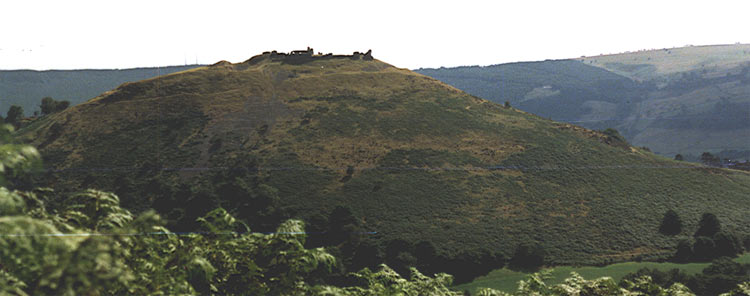
WORLD'S END
Introduction
The evocatively named World's End lies at the heart of a complex terrain which encompasses one of the most wonderful Early Bronze Age communal landscapes in Britain and Ireland.
Its significance is not in large and elaborate monuments, fields and settlements; in fact the visible remains consists of simple cairns and a single 'sanctuary' site above Creigiau Eglwyseg. Instead its fascination lies in the way the monuments are positioned - on rocky crest, on valley-side and on natural boundaries and watersheds - forming the remnant syntax of a little burnt-out cosmos high on these desolate moors (see Burnham 1995, 29-31).
The upland area is small, only about 10 km north-south and 5 km west-east, ramping up like a giant wedge from the lowland of the heavily-occupied Wrexham Plain on the east, to an undulating plateau at between 300-500m OD. For a good deal of its length the western side is abruptly terminated by the Eglwyseg Glen, flanked by the shining limestone cliffs of Creigiau Eglwyseg, Craig Arthur and Craig y Forwen. Many walkers are attracted here from Llangollen, visiting the Iron Age hillfort and Medieval castle of Dinas Bran which guards the entrance to the glen, and sometimes venturing along the turf-covered flat ground along the top of the scarp. World's End is at the head of the glen where the ground rises steeply onto the open moorland. Although there is a small car park here and the modern hill-road penetrates up the headwall and across the open fells, it retains a sense of loneliness and isolation, perhaps partly because it is so close to the settled and comfortable lowlands.
The industrial revolution has left its marks on this area; industrial settlements spread around the eastern flank of the upland - Minera, Coedpoeth, Rhosllanerchrugog Penycae, Ruabon and Acrefair - and the marks of lead mining and limestone quarrying reach high onto the moors [note 1]. Strangely however, unlike many of the archaeologically-rich areas of North Wales, these uplands display very few remains of prehistoric, Medieval and later huts or settlements, or even of 18th and 19th century enclosures and sheepfolds; it is the burial and ritual monuments of the Bronze Age which must form the focus of any assessment of its historic landscape.
Looking at the wider prehistoric context, the region seems to have been of considerable vibrancy and importance in the Bronze Age. It was at the forefront of bronze metalworking traditions and significantly, the Mold gold cape, one of the most remarkable artifacts of the period from Britain was discovered in a barrow only seven miles north of the World's End uplands. Thought by some to have been part of the ceremonial apparel of a shaman or priest, it undoubtedly indicates a society with a measure of wealth, status distinctions, trading and external contacts (Lynch 1991, 73). The distribution and inter-visibility of cairns closer to World's End indicate a widespread structuring of the landscape. Westwards lies the sparsely populated hill country dominated by the shapely Llantysilio Mountains, the highest of which, Moel y Gamelin, is topped by a large cairn. Closer at hand is the shapeless hump of Cyrn-y-Brain with three cairns spread along its elongated top, the highest one being surmounted by the remains of Sir Watkin's Tower. Several barrows and cairns also survive on the lower ground to the north and east [note 2].
A particular feature of the World's End moors is their accessibility from many directions from the low ground, and the cairns display clear patterning relating to the various cwms and watersheds. Thus, bearing in mind that many surely lie on settlement sites (albeit shifting or seasonal), we can perhaps glimpse family/social groupings alive in the landscape, and it is this aspect which forms the theme of the following chapter. Furthermore, assuming the terrain was used mainly as a seasonal resource it was perhaps especially subject to dispute over grazing rights by families and communities based around its circumference. By the Iron Age there were three hillforts or defended sites here, all around the southern fringe of the hills. Dinas Bran dominates both the eastern end of the Vale of Llangollen and the Eglwyseg valley and was perhaps the paramount centre in the locality. Trevor 'camp', two miles further east also faces the Dee valley and controls the southern routes onto the uplands around Tref y Nant. Another two miles north east is the defended site at Gardden Lodge beside the Afon Eitha, also having good access to the mountain slopes [note 3]
Finally, various routeways, sunken paths, droveways and miners paths criss-cross the area, but two stand out as potentially prehistoric in origin. Firstly the east-west trail to the upland pasture at Mountain Lodge which crosses to Worlds End, and secondly a north-south 'through' route up the Eglwyseg valley, past World's End onto the moor, and then down along the Aber Sychnant heading towards Four Crosses.
Note 1: In its 19th century heyday the Minera mines produced 100,000 tons a year and employed 1000 men, but leadmining is recorded here from the late 13th century, and documents show that in the 14th century the mining community enjoyed special privileges (e.g. tax exemption, special courts). They also had use of 100 acres of the lords summer pastures at Hafod yr Arglwydd and Hafod y Wethgar on Minera Mountain (Pratt 1962, esp. p34 re. pasturing ). I don't know the location of these hafodai but Hafod Farm lies at 257515. I suggest that Roman exploitation of the deposits is likely although I'm not aware of any direct evidence].
Note 2: Moel y Gamelin 175465 see Burnham 1995, 29, Cyrn-y-Brain area of 2149. Other sites at e.g. 214548, 259622, 333542, 308477].
Note 3: for Dinas Bran hillfort and Medieval castle site, 223431, see Burnham 1995, 141-2. A Later Bronze Age socketed axe was found near a rabbit hole 150 yards from the summit in 1918 (Ellis Davies 1929, 254). For Trevor Camp, also known as Pen-y-Gaer, 250427 see ibid, 268-9 (including plan). Gardden Lodge fort at 298448].
See here for contents page, or here for the bibliography.
Note: This is part of an original series of articles written by archaeologist M M Robinson.


 We would like to know more about this location. Please feel free to add a brief description and any relevant information in your own language.
 Wir möchten mehr über diese Stätte erfahren. Bitte zögern Sie nicht, eine kurze Beschreibung und relevante Informationen in Deutsch hinzuzufügen.
 Nous aimerions en savoir encore un peu sur les lieux. S'il vous plaît n'hesitez pas à ajouter une courte description et tous les renseignements pertinents dans votre propre langue.
 Quisieramos informarnos un poco más de las lugares. No dude en añadir una breve descripción y otros datos relevantes en su propio idioma.