

Abandoned Landscapes - From Tal y Bont
Submitted by TimPrevett on Monday, 25 September 2006 Page Views: 10598
Multi-periodCountry: Wales County: GwyneddInternal Links:

May 2000
A meandering route taking in the 'core' settlement zone on the coastal side of the range and two of the ancient passes, with a night camping on the mountain ridge.
From the coast to the high ground, visiting Pen y Dinas Hillfort, Carneddau Hengwm Neolithic burial monuments, and crossing the ridge over Bwlch y Rhywgyr
Tal y Bont is a quiet village on the busy coastal road at a crossing point of the Afon Ysgethin a mile before it reaches the sea, and it makes a good base from which to explore the southern Rhinogau. After finishing work on Friday lunchtime I drove through heavy traffic to arrive by mid-afternoon. Five minutes walk from the village is the quiet country lane of Fforrd tyddyn y Felin which heads steeply up towards the hills. Soon I passed an earth bank enclosure set back from the road a little. It is topped by stones and now overgrown with trees and scrub set back from the road. This is the late prehistoric concentric circular enclosure of Tyddyn y Felin (site 1, 598218). A little further on beside a fork in the lane is a series of small cultivation terraces, perhaps also prehistoric [note 1]
I sat on a nearby stone to draw breath; above was the unsettled overcast sky. Below, the caravans colonising the seaside strip were just specks in the distance. Then, leaving the road I followed a track through the farmyard of Eithin-fynydd where an unseen dog barked nearby but there was no sign of people at home. Beyond, drystone walls flank the deeply worn track which follows the contours of the hillside. I stopped to drink from a stream which crosses the track and then entered open cattle pasture to reach the abandoned homestead of Cae'r-llwyn (site 2, 602209). Its drystone walls are intact and the scantling timber roof-frame still holds up some slates which are slowly shearing off into the undergrowth. I poked around in the cool interior; on the left is the kitchen which has a massive timber beam above the fireplace and an in situ rusty cast iron range and kettle. An iron bedstead in the little room on the right indicates the bedroom, which still has a half-loft above. I would guess that this is a mid-late 19th century building perhaps abandoned 50 or so years ago. There are hundreds of such places in areas of rural depopulation, each with its unique residual signature of rooms, decaying furniture, decorations and belongings evoking now-nameless lives. They represent the very first steps on the path of entropy, somewhere between the living household and the buried, spiritless archaeological site (see Morris 2000).
About 100 metres past the buildings, there is a vague winding green way leading west up the grassy slope through an area of clearance cairns, bluebells, ferns and flowering gorse. This took me through a gate at the top of the field from where the little Iron Age hillfort of Pen y Dinas becomes visible (site 3). To reach it means crossing open ground dotted with vestigial walls and structures, probably from a Medieval settlement.
The fort is on an area of locally elevated ground with a single stone bank forming its defence and an additional short length of rampart outside its entrance on the west. From atop the defences the wind buffets and blusters but the views are splendid; far below to the west is the green sea and the coastal strip, whilst in the opposite direction the fields and moors merge into the rising hill mass. This was only a local stronghold, and although sited in a commanding position it doesn't intimidate or dominate the landscape in the way that major hillforts do. However, this place deserves a footnote in the history of archaeology for it was here in 1919 that O.G.S. Crawford, now largely forgotten but probably the most influential British field archaeologist of the 20th century, carried out his first proper fieldwork project. Fresh from the trauma of aerial reconaissance work over the battlefields of Northern France, he arrived at this out-of-the-way place to investigate various sites on behalf of the Cambrian Archaeological Association. As well as trenching the hillfort he dug at the Hengwym circles half a mile to the north east (617213) and surveyed some of the chambered tombs in the area.
His mission in archaeology was to bring 'scientific' standards and professionalism to the discipline. Always the iconoclast he described the CAA employing him as 'a motley crew of amateurs, a survival of Victorian times.' (1955, 150). His approach is reflected by the excavation report in which he describes with typically dogmatic and detailed style how he gridded out and surveyed the sites, but he does acknowledge the hard work of his assistants: 'the work of carrying a staff up and down the ramparts of Pen Dinas on a hot summer day, surrounded by a swarm of flies, demanded a considerable amount of enthusiasm and endurance' (Crawford 1920, 101, 127). The work took from July to September of that year during which time he camped beside the Hengwm circles. We have a vignette of his lifestyle there when a fellow archaeologist visited his camp at mealtime and 'on looking into his frying-pan he found him to be frizzling a mixture of bacon, chocolate and onions.' (Hawkes 1973).
To the south of the hillfort the ground falls rapidly towards the steep-sided little valley of Ceunant Egryn. There are prehistoric settlements to be seen on both sides of the ravine (including another concentric circular enclosure with a central hut circle), and a stone quarry exploited during the building of Harlech castle in the 13th century (see Crew and Musson 1996, 4-5, 7, 15, Bowen and Gresham 1967, 220-2, Lynch 1995, 172).
To reach the Neolithic tombs of Caneddau Hengwm I dropped down from the fort, followed a barely-worn grassy track and passed through a sheepfold complex in a sheltered hollow. Beyond here the ground cover changes from springy turf to wet, rough pasture, which also coincides with the transition from enclosed fields to more open, marginal land which would only sustain year-round occupation with a struggle. As if to exemplify this change in the landscape, a pair of 18th or 19th century homesteads stand abandoned and forlorn beside a stream, their little enclosures and fields sinking inexorably into the moor (607208 and c.613206). From here, a couple of hundred yards further upslope I spotted a heap of stone merging with a field wall which I guessed must be the site of the tombs, and hopping across the stream and following an old track from the cottages soon brought me to them (site 4, 613205).
They stand next to each other on a wide shelf of sloping moorland looking like great stranded sea-mammals atomised into jumbled, elongated heaps of stone. Standing about 2 metres high in places they are set at right-angles to the slope with the upland ends incorporated into a modern drystone wall. The northern monument is the smaller and much more denuded of the two. At the top end are some large flat upright stones and what look like niches inside the remains of a chamber. At the lower end are signs of a collapsed chamber with a large capstone near ground level.
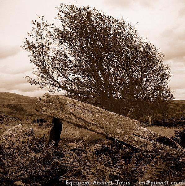
The southern tomb has a chamber with a massive capstone. Like many before me, I peered into this cool small space illuminated by shafts of sunlight filtering through gaps around the capstone. In her magisterial archaeological guide, Jaquetta Hawkes writes '...when I visited the site I had covered the last mile in fierce rain, each drop stinging the face like a viper, and I was happy to plunge beneath the shelter of the capstone and to sit, a female Johah, secure in the this relatively comfortable belly.' (1973 225). 150 years earlier, in 1808, Fenton also came here and records that in one of the chambers 'the Shepherds have formed their Hut and kindle fire and keep their food.' (Fenton 1917, 119), but I saw no sign of this later reuse [note 2]. Clambering up some stepping stones over the field wall I saw that the tomb extends on the far side of the wall, with several very large uprights and a fallen capstone which would have formed the biggest burial chamber of all.
Remarkable monuments on their own, together these tombs are an enigma. Perhaps their pairing signifies the joining of family lineages, symbolising an alliance important enough to require the parallel communal monuments. We cannot recapture their pristine appearance but even today in this bleached skeletal form, this is powerful architecture [note 3].
Angling south east across the rising moor I now headed for a nearby cairn circle, which soon became visible on a small rise with a level area behind it (site 5, 617203). It is very low with angled slabs around the edge sticking out like the tines of a Medieval crown. How remarkable that such a fragile monument as this has survived - although perhaps 2 millenia younger than the nearby Neolithic tombs it has nevertheless stood here for perhaps 3,500 years. As with many Bronze Age ceremonial sites it commands wide views of the terrain around but is not itself conspicuously sited. Just behind it are 2 hut circles and some low enclosure walls, apparently from later reuses of the site and I suspect this site has seen episodes of habitation before and after the cairn was constructed, the preservation of its delicate fabric indicating that despite adjacent occupation it continued to be recognised as a special site.
More signs of occupation survive in the field above the cairn which displays a large hut circle with associated walls (c.618203). At around the 300m contour such sites may have been permanently occupied in warmer periods and associated with localised cultivation as well as stock raising (see for example Hooke 1997 85-6).
The next goal was the ancient pass at Bwlch y Rhiwgyr but rather than heading across and into its gorge, in an effort to avoid losing unnecessary height I traversed awkwardly across its steep stony side. This approach did have a reward however, for tucked away up here on a small level patch overlooking the track far below, is a small isolated ruined hut about 10m by 7m (site 6, c.626201). The walls, made of large stones, survive to about half a metre in height. Because it lies across rather than end-in to the slope I guess it is Post-Medieval rather than a Medieval. Such structures are to be found hidden away on the most unlikely looking hillsides, often only visible from close-by.
The bwlch is a wide rounded notch in the ridge - an inconspicuous Bronze Age cairn near the centre perhaps signifies the boundary of this western territory (site 7). The view ahead from the crest is a mountain dreamscape: Far below are the sinuous shining rivulets twisting amongst the dark sandbanks of the Mawaddach estuary, whilst nearer to hand huge cloud-shadows race each other across the fields and forest. Beyond and above all the magnificent, impalpable mountain ridge of Cadair Idris stretches across the horizon; the same grand vista which greeted the earliest travellers from the coast.
A visit to the pastures of Cwm Afon Dwynant, a night on the ridge-top and a stretch of tough but spectacular walking to Bwlch Drws Ardudwy
There appear to be two traditional ways down from here; one slanting southwards to pass Cerrig Arthur stone circle (site 8) and the other eastwards towards Bontddu. Taking the latter route, a well-made grassy trail (apparently the old coach road) I descended to where it crosses the farm track running up the floor of Cwm Dwynant. At this junction of ways is a spring captured in a sandstone-lined water tank with a couple of steps leading into it; although named the Roman Well, its masonry is presumably much later - perhaps for watering the coach horses (site 9). Nevertheless because of its location below the pass, the spring may have had some symbolic significance in the past and it would be interesting to know of any local traditions relating to it. Close by it is a flat platform built into the slope, its curved edge defined by stones, possibly the remnants of a prehistoric site of some sort (636201) [note 4].
Leaving the old trail I walked up towards the head of this spacious and quiet glen on the valley-bottom track, inadvertently herding dozens of bleating sheep in front. This is the land so memorably evoked by Roger Redfern in describing his time working here as a young man - cutting the hay on the hillside and tending the cattle and sheep (1993), and its also a place where the mountaineer and explorer Harold Tilman walked [see Cadair Idris chapter below].
Uncounted generations have reared stock in this valley, the abandoned farmstead of Caerau adjacent to the track stands near the front of this temporal procession. Associated with it are half a dozen field enclosures, one of which contains a complex fold with a small but intact high-walled shelter roofed by a single large stone slab, possibly a shepherds' hut (site 10, c.640206). Beyond these enclosures the track becomes a wide droveway hemmed in on both sides by drystone walls which then flare apart to form a funnel as if to catch sheep gathering from the pastures of the valley slopes and the uplands beyond. These features presumably relate to the adoption of large-scale commercial sheep-farming, and look to be 18th century or possibly a little earlier (the complex stretches from 639205 to 642208).
Slightly above the droveway on the boggy slopes of the basin I encountered a large ditch system with collapsed walling on the downslope side (site 11). It passes under the field walls and thus seems to belong to entirely separate and earlier arrangements. The ditch still appears fairly crisply cut so it is probably not prehistoric but there are at least 2 small, possibly circular stone foundations adjoining the ditch on the upslope [note 5].
Having made this far too brief inspection of the valley I now wanted to regain the ridge which I managed by cutting west directly up the slope before the rough crags of Craig y Grut. This was tedious and hard but also interspersed with unexpected Post-Medieval remains. Pausing for breath part way up I noticed a rectangular thick-walled stone building set parallel with and cut into the slope with two main rooms plus a smaller room or enclosure attached. As with the building above Bwlch y Rhiwgyr, the ground is too steep for enclosures or fields but it does look like a dwelling rather than a day-shelter. Higher up still I stumbled across a smaller single-celled structure, and a little further on, a fine sheep fold precariously set on steeply sloping rocky ground in the lee of the ridge top. Measuring about 30m X 15m with an internal division reached via a doorway, this is constructed of much thinner walling than the buildings.
By the time I reached the top of the broad ridge, Cadair Idris was just a dark shadowy mass, whilst in front the evening sun blazed off the sea, with the hills of Snowdonia rising across the bay. The barely-worn ridge path courses over undulating grassy terrain towards the main ridge of the Rhinogau. Soon another sheepfold is reached, set at a more gentle angle along the slope, and 50 metres beyond is a smaller, possibly earlier one.
At last I met and crossed the old route up from Pont-Scethin, marked by a small cairn sitting just on the western side of the crest. The slight worn hollow of the trail as it sweeps eastwards above the steep valley-head towards y Braich was just visible [site 12, note 6].
Next was a stretch of classic fell-walking beside the ridge-top wall towards Diffwys in the rising wind and chilly evening air. From the trig point on Diffwys the austere rocky nature of the northerly Rhinogau is exposed on both the lower ground to the east and the rugged ridge to the north. At 9.0clock I found a sheltered camping spot on the far side of the wall on the high scarped ridge just north of Llyn Dulyn. Wrapping up well against the cold I sat out in the fading light to eat supper at a rocky table below which the ground dropped sharply away to the stony wilderness and forest of Cwm Mynach, whilst in the distance beyond lay the open moorland of Crawcwellt. Close behind my bivouac, great banks of cloud poured like dry-ice across the col above Llyn Bodlyn.
The night was cold but very still and I was up and away by 8 o'clock, reaching the summit of Y Llethr an hour later. This is the transition point between easy grassy ridge walking and the intractable sapping rocky ground of the northern Rhinogau - Rhinog Fach, Rhinog Fawr, Craig Wion, Clip and most demanding of all, Moel Ysgyfarnogod. It is these hills that one imagines Giraldus Cambrensis had seen and heard about, and his reference to shepherds 'conversing or disputing' from summit to summit has the ring of truth in that this terrain must always have been more suitable for sheep and goats rather than cattle (see Introduction, above) [note 7].
In thickening drizzle I mislaid the path on the steep descent from Y Lethr and had an entertaining time clambering down to the col on wet boulders, rocks and grass. This col above Llyn Hywel is noted as a wild and grand place, hemmed in by the mountains and the menacing blackness of the llyn itself. When he visited these hills, the indefatigable wild-water swimmer Roger Deakin swam in Llyn Du, Gloyw Llyn and Llyn Eiddew-mawr (Deakin 2000 86-97) but I wonder if even he would have baulked at solo swimming in the gloomy waters of Llyn Hywel.
Without stopping I climbed the path up to Rhinog Fach which was easier and shorter than I'd anticipated, and then as the cloud closed in and rain teemed down I passed first the southern and the northern summit cairns (665270 and 665275). The descent down to Bwlch Drws Ardudwy is the toughest part of this walk. At first there is a clear track west, avoiding the crags towering above the pass to the north, but I soon lost its thread, leaving me to slither and clamber down awful heather and boulder terrain into little Cwmhosan - an undertaking not recommended to walkers hampered by heavy rain, a backpack, and creaking middle-aged knees.
Along the ancient pass of Bwlch Drws Ardudwy and back into the coastal territory visiting sites along the valley of Afon Ysgethin including Pont Scethin, Craig y Dinas hillfort and Cors y Gedol ancient landscape and chambered tomb.
I emerged into the heart of Bwlch Drws Ardudwy, a natural defile which runs for about a mile through the mountains, the crags on either side rising inexorably into the swirling clouds. A quarter of a mile to the east at the high point of the pass where it opens out towards Crawcwellt, is a fine little marker cairn by the path, unusual in that its in a somewhat confined and narrow space (site 13, 664283). But today this wasn’t on my itinerary and instead I walked in the opposite direction along the path beside the Afon Nantcol until the deep pass widened into an open green valley and the trail became floored with flat stone slabs, perhaps originating as a Medieval or later packhorse route with later repairs. Hereabouts I saw humans for the first time since leaving Tal y Bont - two young women who strode through the drizzle up towards the windy and forbidding gap.
I then passed abandoned farmsteads, some standing to eaves height, and reached the little car park at the roadhead beside the farm of Maes y Garnedd. There is a large cairn shortly after the farm, visible as a heap of stones on the far side of a field-barn and sitting squarely in the middle of the valley bottom, perhaps marking both an occupation site and the mouth of the pass (site 14, 642267). As I walked along the quiet road a cuckoo called from across the valley and long-horned cattle ambled across my path.
A few hundred yards after crossing Pont Cerrig I turned off the road onto the bridleway which climbs over the col beside Moelfre towards Pont Scethin. This forms part of the old route from Harlech to London used by travellers and drovers. Initially it is a made track, twisting past several low, ruined structures, probably a variety of post-Medieval farmsteads and stock shelters (vicinity of 631257), and then it makes more or less for the col across bleak moorland. Through the rain and mist I saw a party of 4 or 5 youngsters standing on the boggy ground to the right and I went across to check if they were OK, getting my feet wet in the process. They were from a girls grammar school and, like me, were seeking to cross the hill and reach Pont Scethin. Although they were cold, wet and miserable, they seemed determined to find their own way so I left them to their route-finding.
Following my nose up and over the lowest part of the col I was greeted by lashing rain at the crest. Ahead was the valley of the Afon Ysgethin which throughout its four mile journey towards the coast has been a favoured settlement area for millennia. It is this terrain which I would pass through on my way back to Tal y Bont. Below through the mist I could just see the track in the valley bottom and then I glimpsed Pont Scethin itself. Moving down the slope on an intermittent path I found evidence of Medieval or Post-Medieval habitation clustered around the base of the slope: First a ruined two-roomed building set end-on into the slope on an little sheltered area, with internal wall niches and a small curved enclosure outside. A little further down near the track are another couple of homesteads set on flatter ground. A coaching inn is also supposed to have stood beside the track around here but I didn't locate it [note 8].
Crossing over the track I bog-hopped directly to Pont Scethin, an elegant little bridge where several lady walkers were standing around chatting in the incessant cold drizzle - perhaps waiting for the schoolgirls. The path from the bridge going west leads to two small standing stones set a little distance from each other which probably acted as routemarkers, one visible as you move west up from the river crossing and the other as you approach from the other direction(site 15). Walking south from the stones brings you to a small ridge above the low wet floodplain of the Afon Ysgethin, at the end of which stands the little fort of Craig y Dinas (site 16). Keeping my eyes peeled I noted several platforms and small circular enclosures on the way. The fort is an impressive construction consisting of a massively thick stone wall still up to 2 metres in height; inside the ground is uneven and rocky and it is difficult to imagine this being a comfortable place to live (625230). Adjacent to and below the fort are walls and enclosures of Medieval and later date.
Cold, wet, tired, and with my map turning to inky blotting paper in its supposedly waterproof case, I retraced my steps to the metalled track and sloshed along unhappily until I reached Cors y Gedol, a marvellous fragment of ancient landscape near the river above Pont Fadog (site 17, centred on 605228). This is rough pasture and gorse scrub with patches of bluebells wilting in the rain. The archaeological remains are everywhere - banks and ditches, numerous clearance cairns and low overgrown walls. On such a fleeting visit it is difficult to make sense of this complex palimpsest of remains which investigation has shown to include prehistoric, Roman, Medieval and later settlement, enclosures and fields. It seems little changed from 1800 when Fenton described it as 'a large Field, covered over with marks of old enclosures in all directions, and of all shapes and sizes, interspersed with Heaps of Stones in a circular form' (1917, 97).
Stumbling disorientated onto the road from the high gorse at the south end of the site I searched for the nearby Neolithic burial chamber which I found around a bend in the road in coarse pasture amongst hawthorns and thistles (603228). This has a small chamber formed by a single upright and fallen capstone which on this day harboured a dry and contented lamb. The remnants of the cairn are scattered and heaped around. Half an hour's walk on the bridleway through delightful deciduous woodland alongside the Afon Ysgethin brought me back to the centre of Tal y Bont [note 9].
Note 1: This concentric circle enclosure has a large stone built circular bank 40m in diameter and an outer bank c.60m in diameter, being one of a relatively small group of such sites, probably of late Iron Age date and thought to be high status settlements, with the dwelling house located inside the inner enclosure and cattle kept in the outer one (Bowen and Gresham 1967, 206-24, esp. 214). The terrace may be part of the system of terraced fields noted by Bowen and Gresham along the coastal strip from Afon Ysgethin to Llanaber lying between the 50-500ft contour (203-4).
Note 2: This is a rare first hand account of a small shepherd's shelter noted elsewhere in this book.
Note 3: Bowen and Gresham observe that robbing and alteration for the enclosure walls in the 19th century has left 'but the last untidy ruin of the great, regular, and neatly finished mounds that once must have stood here.' (11 and 9-15), See also aerial photo in Crew and Musson 1996, 10.
Note 4: Fenton gives a good description of the topography and land use around this route from Bontddu to the pass (1917, 118-9)]. Also, see below (Cadair Idris chapter) for suggestions about the continuation of this route beyond Bontddu.
Note 5: (639208) These features left me perplexed - the structural remains may be the hut circles marked on the map around here. The ditch may be the feature shown on the map as a drain/watercourse but I don't believe this was its original purpose.
Note 6: This course across Y Braich may be Roman in origin as Waddilove argues (1999 308-12) but the prehistoric usage of this pass is indicated not just by the marker cairn but by the proximity of several Bronze Age monuments along the route to the west (see below).
Note 7: I'm also struck by this image of the shepherds shouting between hilltops and the parallels one can draw between long-distance vocal communication in other mountain regions such as the Alps (Horden and Purcell 2000 124).
Note 8: Sites in vicinity of 634242. The drove route is described in detail by Godwin and Toulson 1977 98-9
Note 9: See Crew and Musson 1996 for plan and aerial photo of the landscape, also Bowen and Gresham 1967, 19-21. An engraving of the tomb in 1800 is shown in Crawford 1920 opp. p99.
See here for contents page, or here for the bibliography.
Note: This is part of an original series of articles written by archaeologist M M Robinson.


 We would like to know more about this location. Please feel free to add a brief description and any relevant information in your own language.
 Wir möchten mehr über diese Stätte erfahren. Bitte zögern Sie nicht, eine kurze Beschreibung und relevante Informationen in Deutsch hinzuzufügen.
 Nous aimerions en savoir encore un peu sur les lieux. S'il vous plaît n'hesitez pas à ajouter une courte description et tous les renseignements pertinents dans votre propre langue.
 Quisieramos informarnos un poco más de las lugares. No dude en añadir una breve descripción y otros datos relevantes en su propio idioma.