

<< Text Pages >> Churchmoor Hill North - Cairn in England in Shropshire
Submitted by George998 on Monday, 31 March 2025 Page Views: 1507
Neolithic and Bronze AgeSite Name: Churchmoor Hill NorthCountry: England County: Shropshire Type: Cairn
Nearest Town: Church Stretton
Map Ref: SF905403
Latitude: 52.870890N Longitude: 6.600751W
Condition:
| 5 | Perfect |
| 4 | Almost Perfect |
| 3 | Reasonable but with some damage |
| 2 | Ruined but still recognisable as an ancient site |
| 1 | Pretty much destroyed, possibly visible as crop marks |
| 0 | No data. |
| -1 | Completely destroyed |
| 5 | Superb |
| 4 | Good |
| 3 | Ordinary |
| 2 | Not Good |
| 1 | Awful |
| 0 | No data. |
| 5 | Can be driven to, probably with disabled access |
| 4 | Short walk on a footpath |
| 3 | Requiring a bit more of a walk |
| 2 | A long walk |
| 1 | In the middle of nowhere, a nightmare to find |
| 0 | No data. |
| 5 | co-ordinates taken by GPS or official recorded co-ordinates |
| 4 | co-ordinates scaled from a detailed map |
| 3 | co-ordinates scaled from a bad map |
| 2 | co-ordinates of the nearest village |
| 1 | co-ordinates of the nearest town |
| 0 | no data |
Internal Links:
External Links:
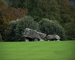
Cairn in Shropshire
Marked as tumulus on OS map. This one is the second northernmost of the 5 marked.
Evidence of a small excavation on northern side.
You may be viewing yesterday's version of this page. To see the most up to date information please register for a free account.
")
Do not use the above information on other web sites or publications without permission of the contributor.
Nearby Images from Geograph Britain and Ireland:

©2019(licence)

©2019(licence)

©2019(licence)
The above images may not be of the site on this page, they are loaded from Geograph.
Please Submit an Image of this site or go out and take one for us!
Click here to see more info for this site
Nearby sites
Key: Red: member's photo, Blue: 3rd party photo, Yellow: other image, Green: no photo - please go there and take one, Grey: site destroyed
Download sites to:
KML (Google Earth)
GPX (GPS waypoints)
CSV (Garmin/Navman)
CSV (Excel)
To unlock full downloads you need to sign up as a Contributory Member. Otherwise downloads are limited to 50 sites.
Turn off the page maps and other distractions
Nearby sites listing. In the following links * = Image available
5.1km SW 236° Haroldstown* Portal Tomb (S90087793)
5.3km SSE 156° Clonmore* Ancient Cross
8.4km N 356° Boleycarrigeen* Stone Circle
8.5km NNW 346° Gates Of Heaven Burial Chamber or Dolmen
8.7km SSW 209° Rathgall Hill Fort* Hillfort (S90227315)
8.9km SSW 210° Rathgall Destroyed Stone Circle Stone Circle (S900730)
10.1km NNW 327° Baltinglass* Passage Grave (S8855289249)
10.3km N 354° Brusselstown Ring* Hillfort (S9304791108)
12.9km N 353° Castleruddery Stone Row / Alignment (S925937)
13.6km N 350° Castleruddery* Stone Circle (S9159394210)
13.9km SW 228° Ardristan* Standing Stone (Menhir) (S8413871337)
14.5km NNE 17° The Long Stone (Knickeen)* Standing Stone (Menhir) (S983948)
16.3km WNW 286° Castledermot High Crosses* Ancient Cross
19.2km W 259° Browne’s Hill* Portal Tomb (S7538476873)
19.3km NW 309° Moone High Cross* Ancient Cross (S7891192693)
20.4km NNW 340° Tournant Stone Circle (N870000)
22.3km N 358° Athgreany* Stone Circle (N9300003200)
22.7km NE 49° Glendalough settlement and pilgrim cross* Ancient Village or Settlement
23.1km NNW 333° Brewel Hill Stone Circle (N833013)
24.3km NE 50° The Glendalough Cross and Deer Stone* Early Christian Sculptured Stone (T126969)
25.2km SW 228° Knockroe Decorated Stone* Rock Art (S7573063758)
25.4km NNW 335° Kilgowan* Standing Stone (Menhir)
25.9km N 358° Whiteleas Stone Circle
26.7km N 358° Broadleas* Stone Circle (N9292507609)
28.5km NNW 338° Old Kilcullen High Cross Ancient Cross
View more nearby sites and additional images


 We would like to know more about this location. Please feel free to add a brief description and any relevant information in your own language.
 Wir möchten mehr über diese Stätte erfahren. Bitte zögern Sie nicht, eine kurze Beschreibung und relevante Informationen in Deutsch hinzuzufügen.
 Nous aimerions en savoir encore un peu sur les lieux. S'il vous plaît n'hesitez pas à ajouter une courte description et tous les renseignements pertinents dans votre propre langue.
 Quisieramos informarnos un poco más de las lugares. No dude en añadir una breve descripción y otros datos relevantes en su propio idioma.