<< Our Photo Pages >> Grassholm Island - Ancient Village or Settlement in Wales in Pembrokeshire
Submitted by bat400 on Tuesday, 23 July 2013 Page Views: 17067
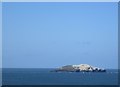
Multi-periodSite Name: Grassholm IslandCountry: Wales County: Pembrokeshire Type: Ancient Village or Settlement
Map Ref: SM5985909317
Latitude: 51.730994N Longitude: 5.479012W
Condition:
| 5 | Perfect |
| 4 | Almost Perfect |
| 3 | Reasonable but with some damage |
| 2 | Ruined but still recognisable as an ancient site |
| 1 | Pretty much destroyed, possibly visible as crop marks |
| 0 | No data. |
| -1 | Completely destroyed |
| 5 | Superb |
| 4 | Good |
| 3 | Ordinary |
| 2 | Not Good |
| 1 | Awful |
| 0 | No data. |
| 5 | Can be driven to, probably with disabled access |
| 4 | Short walk on a footpath |
| 3 | Requiring a bit more of a walk |
| 2 | A long walk |
| 1 | In the middle of nowhere, a nightmare to find |
| 0 | No data. |
| 5 | co-ordinates taken by GPS or official recorded co-ordinates |
| 4 | co-ordinates scaled from a detailed map |
| 3 | co-ordinates scaled from a bad map |
| 2 | co-ordinates of the nearest village |
| 1 | co-ordinates of the nearest town |
| 0 | no data |
Internal Links:
External Links:
I have visited· I would like to visit
PAB has visited here
")
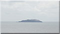
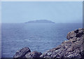
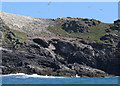
Blissful forgetfulness was the condition of a prehistoric community on this tiny island of only 22 acres. Surveys from the 1970's and 2011, primarily to watch over a huge site of gannets on this National Nature Reserve, also revealed occupation along the ridge of the island. Recent visits noted roundhouses and field boundaries.
Grassholm's name comes from the Vikings who frequently raided the area in the 9-10th century. In folklore, the island has been identified with Gwales, an island featured in the Mabinogion - the site of a fabulous castle where the severed head of Bran the Blessed is kept miraculously alive for eighty years while his companions feast in blissful forgetfulness.
Located 15 miles off the southwest Pembrokeshire coast. The island is owned by the Royal Society for the Protection of Birds (RSPB.) The location given is general for the island, and not for specific structures.
Note: Ground Survey Revealed Traces of Roundhouses and Field Boundaries indicating that this tiny island was also once home to a thriving prehistoric community.
You may be viewing yesterday's version of this page. To see the most up to date information please register for a free account.
Do not use the above information on other web sites or publications without permission of the contributor.
Nearby Images from Geograph Britain and Ireland:
©2017(licence)
©2018(licence)
©2009(licence)
©2018(licence)
©2018(licence)
The above images may not be of the site on this page, they are loaded from Geograph.
Please Submit an Image of this site or go out and take one for us!
Click here to see more info for this site
Nearby sites
Key: Red: member's photo, Blue: 3rd party photo, Yellow: other image, Green: no photo - please go there and take one, Grey: site destroyed
Download sites to:
KML (Google Earth)
GPX (GPS waypoints)
CSV (Garmin/Navman)
CSV (Excel)
To unlock full downloads you need to sign up as a Contributory Member. Otherwise downloads are limited to 50 sites.
Turn off the page maps and other distractions
Nearby sites listing. In the following links * = Image available
11.7km E 88° Skomer Island Stone Row / Alignment (SM71620911)
12.0km E 88° Skomer south west settlements* Ancient Village or Settlement (SM71900910)
12.5km E 85° North Skomer settlement Ancient Village or Settlement (SM7240009900)
12.8km E 84° Earthfast natural slab in north east Skomer* Natural Stone / Erratic / Other Natural Feature (SM72660998)
13.5km E 86° Skomer Stone* Standing Stone (Menhir) (SM73360952)
13.7km E 89° South Castle Promontory Fort Promontory Fort / Cliff Castle (SM73590892)
14.0km ESE 107° Skokholm* Not Known (by us) (SM731045)
16.0km E 89° Martin's Haven* Hillfort (SM759089)
16.1km E 89° Renney Slip Hillfort (SM760089)
16.2km E 88° Ring-Stone, Martin's Haven* Early Christian Sculptured Stone (SM761090)
17.0km E 95° Gateholm Island* Ancient Village or Settlement (SM768071)
17.0km E 92° Victoria Bay* Hillfort (SM769079)
17.1km NNE 32° Carn Llundain (South)* Cairn (SM69652331)
18.2km NNE 32° Ramsay Monolith* Modern Stone Circle etc (SM70302428)
18.3km NNE 31° Carn Ysgubor Cairn (SM69992460)
18.6km NE 37° Lower Treginnis Cairn (SM718236)
19.1km E 83° Tower Point* Promontory Fort / Cliff Castle (SM790108)
19.2km E 82° Nab Head (Pembrokeshire)* Ancient Village or Settlement (SM79051111)
19.8km NE 36° Castell Henif* Promontory Fort / Cliff Castle (SM72362469)
20.2km NE 35° St Justinian's Well* Holy Well or Sacred Spring (SM72402522)
20.3km E 98° Great Castle Head Hillfort (SM799057)
20.3km NE 35° St Justinians North* Standing Stone (Menhir) (SM7237625371)
20.3km NE 36° St Justinians East* Standing Stone (Menhir) (SM7252725278)
20.4km NE 41° Porth Clais well* Holy Well or Sacred Spring (SM739242)
20.5km ESE 103° Little Castle Point Hillfort (SM797038)
View more nearby sites and additional images


 We would like to know more about this location. Please feel free to add a brief description and any relevant information in your own language.
 Wir möchten mehr über diese Stätte erfahren. Bitte zögern Sie nicht, eine kurze Beschreibung und relevante Informationen in Deutsch hinzuzufügen.
 Nous aimerions en savoir encore un peu sur les lieux. S'il vous plaît n'hesitez pas à ajouter une courte description et tous les renseignements pertinents dans votre propre langue.
 Quisieramos informarnos un poco más de las lugares. No dude en añadir una breve descripción y otros datos relevantes en su propio idioma.