Featured: How and why the ancients enchanted Great Britain and Brittany

How and why the ancients enchanted Great Britain and Brittany

Random Image


Doksrud Hillfort

Secrets of the Avebury Stones

Secrets of the Avebury Stones

Who's Online

There are currently, 283 guests and 3 members online.

You are a guest. To join in, please register for free by clicking here

Sponsors

<< Our Photo Pages >> Skomer Stone - Standing Stone (Menhir) in Wales in Pembrokeshire

Submitted by PAB on Friday, 04 March 2011  Page Views: 19083

Neolithic and Bronze AgeSite Name: Skomer Stone Alternative Name: Harold Stone
Country: Wales County: Pembrokeshire Type: Standing Stone (Menhir)
Nearest Town: Haverfordwest  Nearest Village: Marloes
Map Ref: SM73360952  Landranger Map Number: 157
Latitude: 51.738438N  Longitude: 5.283985W
Condition:
5Perfect
4Almost Perfect
3Reasonable but with some damage
2Ruined but still recognisable as an ancient site
1Pretty much destroyed, possibly visible as crop marks
0No data.
-1Completely destroyed
4 Ambience:
5Superb
4Good
3Ordinary
2Not Good
1Awful
0No data.
4 Access:
5Can be driven to, probably with disabled access
4Short walk on a footpath
3Requiring a bit more of a walk
2A long walk
1In the middle of nowhere, a nightmare to find
0No data.
2 Accuracy:
5co-ordinates taken by GPS or official recorded co-ordinates
4co-ordinates scaled from a detailed map
3co-ordinates scaled from a bad map
2co-ordinates of the nearest village
1co-ordinates of the nearest town
0no data
4

Internal Links:
External Links:

Skomer Stone
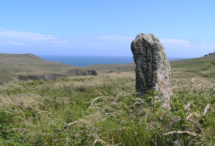
Skomer Stone submitted by Robc : OS157 SM715090 Although the Skomer island is famous for its birds it has quite a few historical attractions. The Bronze age Standing Stone pictured is call Harold's Stone. The island also has many Iron Age field boundaries and cairn groups and a promantory Hill fort. (but this is on the one part of the island that is not accessible to the general public). (Vote or comment on this photo)
This stone is not on the map so may be modern [it appears RCAHMW think it is ancient, see comment below - MegP Ed] but there are no less than four ancient settlements on this tiny island with numerous hut circles. RSPB reserve with access by launch from Martins Haven.

The stone referred to as the Skomer stone - also referred to in leaflets as 'Harold Stone' - is close to remains of 'huts, fields and cairns which represent one of the most complete areas of pre-historic settlement in the British Isles'.

I have to admit however that, on this occasion, ancient sites hardly featured in my photos when I visited for the first time in July 2008 - puffins landing & walking within feet of me won without contest. I think the undergrowth would have to be much reduced for the signs of early settlement to be visible.

Note: Royal Commission investigators Toby Driver and Louise Barker look at a well preserved prehistoric settlement on Skomer and speculate about the use of the standing stone as a navigation marker
You may be viewing yesterday's version of this page. To see the most up to date information please register for a free account.
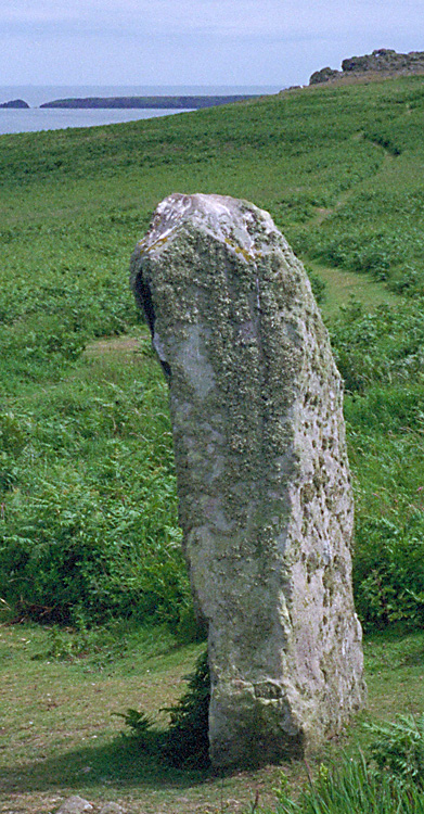
Skomer Stone
Skomer Stone submitted by Thorgrim : SM736096. It is not on the map so may be modern, but there are no less than four ancient settlements on this tiny island with numerous hut circles. RSPB reserve with access by launch from Martins Haven. (Vote or comment on this photo)

Skomer Stone
Skomer Stone submitted by pab : Skomer, July 2008. Visitors to Skomer can follow 'historic' trails as well as nature ones - a leaflet is available at the landing point. This reminds visitors that Skomer will have been joined to the mainland until the sea level rose following the end of the latest glaciation...and also that there is 'exceptional evidence of an Iron age farming community that may have numbered up to 200 people... (2 comments - Vote or comment on this photo)

Skomer Stone
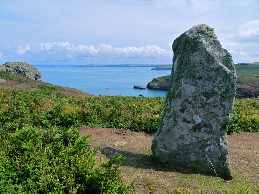
Skomer Stone submitted by Flickr : Harold Stone This standing stone is to be found on Skomer Island, Pembrokeshire, West Wales. Although 'undated' it is widely belived to be prehistoric / Bronze Age. Image copyright: Vertigo Rod (Rhodri ap Hywel), hosted on Flickr and displayed under the terms of their API. (Vote or comment on this photo)

Skomer Stone
Skomer Stone submitted by paulcall : Can anyone identify this stone for me? I took it in Pembrokeshire on a family holiday many years ago. I think it may be Harolds Stone on Skomer. Anyone agree? (3 comments - Vote or comment on this photo)

Skomer Stone
Skomer Stone submitted by pab : The stone referred to on the Portal as Skomer stone - also referred to in leaflets as 'Harold Stone' - is close to remains of 'huts, fields and cairns which represent one of the most complete areas of pre-historic settlement in the British Isles'. I have to admit however that, on this occasion, ancient sites hardly featured in my photos when I visited for the first time in July 2008 - puffins...

Do not use the above information on other web sites or publications without permission of the contributor.
Click here to see more info for this site

Nearby sites

Click here to view sites on an interactive OS map

Key: Red: member's photo, Blue: 3rd party photo, Yellow: other image, Green: no photo - please go there and take one, Grey: site destroyed

Download sites to:
KML (Google Earth)
GPX (GPS waypoints)
CSV (Garmin/Navman)
CSV (Excel)

To unlock full downloads you need to sign up as a Contributory Member. Otherwise downloads are limited to 50 sites.


Turn off the page maps and other distractions

Nearby sites listing. In the following links * = Image available
 642m SSE 157° South Castle Promontory Fort Promontory Fort / Cliff Castle (SM73590892)
 835m WNW 301° Earthfast natural slab in north east Skomer* Natural Stone / Erratic / Other Natural Feature (SM72660998)
 1.0km WNW 289° North Skomer settlement Ancient Village or Settlement (SM7240009900)
 1.5km WSW 251° Skomer south west settlements* Ancient Village or Settlement (SM71900910)
 1.8km WSW 254° Skomer Island Stone Row / Alignment (SM71620911)
 2.6km E 101° Martin's Haven* Hillfort (SM759089)
 2.7km E 101° Renney Slip Hillfort (SM760089)
 2.8km E 98° Ring-Stone, Martin's Haven* Early Christian Sculptured Stone (SM761090)
 3.9km ESE 112° Victoria Bay* Hillfort (SM769079)
 4.2km ESE 123° Gateholm Island* Ancient Village or Settlement (SM768071)
 5.0km S 180° Skokholm* Not Known (by us) (SM731045)
 5.8km ENE 75° Tower Point* Promontory Fort / Cliff Castle (SM790108)
 5.9km ENE 72° Nab Head (Pembrokeshire)* Ancient Village or Settlement (SM79051111)
 7.6km ESE 118° Great Castle Head Hillfort (SM799057)
 8.5km SE 130° Little Castle Point Hillfort (SM797038)
 9.6km E 99° Mabesgate Longstone* Standing Stone (Menhir) (SM828076)
 9.8km ESE 114° Dale Fort* Hillfort (SM822052)
 11.5km E 93° Sandy Haven's Farm* Standing Stone (Menhir) (SM848084)
 11.5km E 93° Longstone Field Standing Stone (Menhir) (SM84870842)
 11.6km E 93° Longstone Field Circle 2 Timber Circle (SM849084)
 11.6km E 93° Longstone Field Circle 1 Timber Circle (SM849084)
 13.5km W 267° Grassholm Island* Ancient Village or Settlement (SM5985909317)
 13.5km ENE 67° Upper Lodge* Stone Row / Alignment (SM861142)
 13.6km ESE 122° Whitedole Bay Hillfort (SM846018)
 13.8km ENE 65° Harold Stone (Broad Haven) Standing Stone (Menhir) (SM8615514717)
View more nearby sites and additional images

<< Selinous

Stephen's Castle Tumulus >>

Please add your thoughts on this site

Stonehenge: Celebration and Subversion

Stonehenge: Celebration and Subversion

Sponsors

Auto-Translation (Google)

Translate from English into:

"Skomer Stone" | Login/Create an Account | 5 News and Comments
  
Go back to top of page    Comments are owned by the poster. We aren't responsible for their content.
Re: Skomer Stone by Anonymous on Thursday, 10 March 2011
The stone is on the map (OS 25,000) and is identified as Harold Stone and is believed to be neolithic or bronze age

http://www.coflein.gov.uk/en/site/305372/details/HAROLD+STONE,+SKOMER/

Harold stone seems to be a favoured name as I can think of at leas 2 others in Pembrokeshire
[ Reply to This ]

Re: Skomer Stone by Sunny100 on Friday, 04 March 2011
(User Info | Send a Message)
According to Coflein, the stone known as 'Harold Stone' on Skomer is named after Earl Harold to commemorate his victories over the Welsh in 1063. However, the stone is probably Bronze Age in date and pre-dates Harold.
[ Reply to This ]

Re: Skomer Island Preserved Remains Of A Prehistoric Settlement by Sunny100 on Friday, 04 March 2011
(User Info | Send a Message)
Thanks PAB for sharing this site with us, very interesting place and a nice standing stone. Wonder what the name Harold Stone means ?
[ Reply to This ]

Skomer Island Preserved Remains Of A Prehistoric Settlement by Andy B on Friday, 04 March 2011
(User Info | Send a Message)
Skomer Island (a Scandinavian word which describes the cloven shape of the island) ranks among the finest archaeological landscapes in Britain. Royal Commission investigators Toby Driver and Louise Barker look at how comparative isolation from the mainland, and the limited impact of recent agriculture, has preserved the remains of prehistoric settlement.

The remoteness of Skomer Island means that considerable tracts have not been ploughed or built on since prehistoric times. It is now famed for its wildlife and ecosystems, but on the unploughed parts of the island small huts, animal pounds, farmsteads and elaborate systems of fields survive from the Bronze and Iron Ages to show us the ways in which our prehistoric ancestors lived and worked the land. A detailed survey by John Evans, published in 1990, together with earlier survey work by W F Grimes, represent our main source of information.

The soils on Skomer are known to be fertile and were farmed in recent centuries. When prehistoric founding communities first made the crossing to Skomer it is thought the island would have presented a favourable habitat, with a light covering of oak woodland, an equable climate, and a number of freshwater springs and streams. Prehistoric settlements chiefly survive on the peripheries of the island, while in the central area, fields dating from the eighteenth century and farmed until 1948, have largely obliterated any traces of earlier structures, in a pattern repeated endless times across mainland Pembrokeshire. Traces of life are abundant within these small hamlets. Mounds of burnt stone close to houses are probably evidence for cooking sites, whilst funnel entrances to some farms, and isolated circular or D-shaped enclosures, are tangible evidence of stock management. Indeed, prehistoric fields, originally used for grazing sheep, cattle and even pigs, radiate outwards from the hamlets and their outcrops. A mixed economy of livestock and cereals would have been supplemented with coastal and marine resources: sea-birds and their eggs, seals and seaweed, plus a range of shellfish and sea-fish. In all, the Skomer families would have enjoyed a varied and nutritious diet. Groups of stone cairns along more remote coastal headlands may be burial monuments, or evidence for organised field clearance where they occur closer to farms.

One prominent reminder of prehistoric ritual and burial on the island is The Harold Stone, a 1.7 metre high standing stone. It tapers from a broad base to a point, with its edges aligned nearly north-south; its wide face is orientated to face the sea to the east and the island to the west. Although the Harold Stone is currently undated, excavations at other similar stones in Pembrokeshire have always yielded a prehistoric, Bronze Age, date. It is therefore safe to assume that this stone is also a Bronze Age monument, marking a burial (in a cremation urn) or an area of now buried ritual and funerary activity. Sian Rees (Cadw) has noted that the Harold Stone stands as a prominent marker on the skyline as one approaches by sea and may have been used as a transit marker to clear submerged dangers. This is also a useful hypothesis. The stone does not have an obvious relationship to the adjacent prehistoric field boundaries that pass close to it on the west side, however, it does stand towards the eastern end of a distinct block of fields, not far to the south of a prominent outcrop that no doubt provided a convenient slab. Therefore the stone may have stood at the edge of a contemporary plot of fields. Other cairns and mounds are known from Skomer, at least some of which may be burial cairns contemporary with this standing stone.

More, with a photo of the settlement, and also in Welsh at
http://heritageofwalesnews.blogspot.com/2011/03/skomer-island-preserved-remains-of.html
[ Reply to This ]

Re: Skomer Stone by coldrum on Tuesday, 20 January 2009
(User Info | Send a Message)
RCAHMW record:

http://www.coflein.gov.uk/en/site/305372/details/HAROLD+STONE%2C+SKOMER/
[ Reply to This ]

Your Name: Anonymous [ Register Now ]
Subject:


Add your comment or contribution to this page. Spam or offensive posts are deleted immediately, don't even bother

<<< What is five plus one as a number? (Please type the answer to this question in the little box on the left)
You can also embed videos and other things. For Youtube please copy and paste the 'embed code'.
For Google Street View please include Street View in the text.
Create a web link like this: <a href="https://www.megalithic.co.uk">This is a link</a>  

Allowed HTML is:
<p> <b> <i> <a> <img> <em> <br> <strong> <blockquote> <tt> <li> <ol> <ul> <object> <param> <embed> <iframe>

We would like to know more about this location. Please feel free to add a brief description and any relevant information in your own language.
Wir möchten mehr über diese Stätte erfahren. Bitte zögern Sie nicht, eine kurze Beschreibung und relevante Informationen in Deutsch hinzuzufügen.
Nous aimerions en savoir encore un peu sur les lieux. S'il vous plaît n'hesitez pas à ajouter une courte description et tous les renseignements pertinents dans votre propre langue.
Quisieramos informarnos un poco más de las lugares. No dude en añadir una breve descripción y otros datos relevantes en su propio idioma.