<< Our Photo Pages >> Flutters Hill Barrow - Round Barrow(s) in England in Surrey
Submitted by SolarMegalith on Thursday, 30 June 2011 Page Views: 4454
Neolithic and Bronze AgeSite Name: Flutters Hill BarrowCountry: England County: Surrey Type: Round Barrow(s)
Nearest Town: Chertsey Nearest Village: Longcross
Map Ref: SU99206516
Latitude: 51.376837N Longitude: 0.576103W
Condition:
| 5 | Perfect |
| 4 | Almost Perfect |
| 3 | Reasonable but with some damage |
| 2 | Ruined but still recognisable as an ancient site |
| 1 | Pretty much destroyed, possibly visible as crop marks |
| 0 | No data. |
| -1 | Completely destroyed |
| 5 | Superb |
| 4 | Good |
| 3 | Ordinary |
| 2 | Not Good |
| 1 | Awful |
| 0 | No data. |
| 5 | Can be driven to, probably with disabled access |
| 4 | Short walk on a footpath |
| 3 | Requiring a bit more of a walk |
| 2 | A long walk |
| 1 | In the middle of nowhere, a nightmare to find |
| 0 | No data. |
| 5 | co-ordinates taken by GPS or official recorded co-ordinates |
| 4 | co-ordinates scaled from a detailed map |
| 3 | co-ordinates scaled from a bad map |
| 2 | co-ordinates of the nearest village |
| 1 | co-ordinates of the nearest town |
| 0 | no data |
Internal Links:
External Links:
I have visited· I would like to visit
SolarMegalith visited on 4th Nov 2011 - their rating: Cond: 2 Amb: 3 Access: 3
")
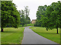
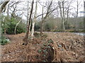
Indeed, at first glance the mound looked like part of a natural ridge for me, but location on slope of the hill could explain this. After all, most of the availible sources point out this mound as site of a bowl barrow.
Read more at Pastscape
Read More at Defra Magic Map.
You may be viewing yesterday's version of this page. To see the most up to date information please register for a free account.
")
")
")
Do not use the above information on other web sites or publications without permission of the contributor.
Nearby Images from Geograph Britain and Ireland:
©2016(licence)
©2011(licence)
©2017(licence)
©2015(licence)
©2011(licence)
The above images may not be of the site on this page, they are loaded from Geograph.
Please Submit an Image of this site or go out and take one for us!
Click here to see more info for this site
Nearby sites
Key: Red: member's photo, Blue: 3rd party photo, Yellow: other image, Green: no photo - please go there and take one, Grey: site destroyed
Download sites to:
KML (Google Earth)
GPX (GPS waypoints)
CSV (Garmin/Navman)
CSV (Excel)
To unlock full downloads you need to sign up as a Contributory Member. Otherwise downloads are limited to 50 sites.
Turn off the page maps and other distractions
Nearby sites listing. In the following links * = Image available
506m S 190° Longcross Barrow* Round Barrow(s) (SU99126466)
612m NNW 327° Barrowhills Round Barrow(s) (SU98866567)
1.3km S 172° Chobham Common (1)* Misc. Earthwork (SU994639)
2.0km WSW 245° Albury Bottom Enclosure* Misc. Earthwork (SU97426430)
3.1km NNW 338° Leptis Magna (Virginia Waters)* Ancient Temple (SU980680)
4.2km NE 53° The Nun's Well (Surrey)* Holy Well or Sacred Spring (TQ0247767756)
4.2km NE 55° St Ann's Hill* Hillfort (TQ026676)
4.2km WNW 288° Sunningdale Barrows Round Barrow(s) (SU952664)
5.1km ENE 70° Chertsey Museum Museum (TQ040670)
5.6km S 185° Horsell Birch Natural Stone / Erratic / Other Natural Feature (SU98805956)
5.8km SSE 159° Horsell Common W* Barrow Cemetery (TQ01405980)
5.9km SSE 157° Horsell Common E* Round Barrow(s) (TQ01615977)
6.7km SSW 214° St John the Baptist's Well* Holy Well or Sacred Spring (SU956595)
6.8km WSW 236° New England Barrow Round Barrow(s) (SU93616129)
7.1km WSW 239° West End Common Barrows* Barrow Cemetery (SU931614)
7.3km NNE 32° Negen Stones Standing Stones (TQ030714)
7.4km SE 135° Jack Temple Healing Centre* Modern Stone Circle etc (TQ045600)
7.9km SE 145° Pyrford Stone* Marker Stone (TQ0382258782)
8.1km NNE 24° Staines Enclosure* Causewayed Enclosure (TQ024726)
8.6km WNW 296° Bowledge Hill Bell Barrow* Round Barrow(s) (SU91336872)
8.9km NE 45° Ashford Henge* Henge (TQ054715)
9.0km ENE 71° Shepperton Henge* Henge (TQ07686832)
9.9km ESE 111° St George's Hill* Hillfort (TQ085618)
10.3km NNE 15° Kingsmead Quarry* Ancient Village or Settlement (TQ01707520)
10.3km WNW 284° Swinley Park Barrow* Round Barrow(s) (SU89106754)
View more nearby sites and additional images


 We would like to know more about this location. Please feel free to add a brief description and any relevant information in your own language.
 Wir möchten mehr über diese Stätte erfahren. Bitte zögern Sie nicht, eine kurze Beschreibung und relevante Informationen in Deutsch hinzuzufügen.
 Nous aimerions en savoir encore un peu sur les lieux. S'il vous plaît n'hesitez pas à ajouter une courte description et tous les renseignements pertinents dans votre propre langue.
 Quisieramos informarnos un poco más de las lugares. No dude en añadir una breve descripción y otros datos relevantes en su propio idioma.