


<< Our Photo Pages >> Round Hill West - Cairn in England in Yorkshire (North)
Submitted by SolarMegalith on Monday, 31 July 2017 Page Views: 1308
Neolithic and Bronze AgeSite Name: Round Hill WestCountry: England
NOTE: This site is 0.5 km away from the location you searched for.
County: Yorkshire (North) Type: Cairn
Nearest Village: Seave Green
Map Ref: NZ5913101602
Latitude: 54.406450N Longitude: 1.090544W
Condition:
| 5 | Perfect |
| 4 | Almost Perfect |
| 3 | Reasonable but with some damage |
| 2 | Ruined but still recognisable as an ancient site |
| 1 | Pretty much destroyed, possibly visible as crop marks |
| 0 | No data. |
| -1 | Completely destroyed |
| 5 | Superb |
| 4 | Good |
| 3 | Ordinary |
| 2 | Not Good |
| 1 | Awful |
| 0 | No data. |
| 5 | Can be driven to, probably with disabled access |
| 4 | Short walk on a footpath |
| 3 | Requiring a bit more of a walk |
| 2 | A long walk |
| 1 | In the middle of nowhere, a nightmare to find |
| 0 | No data. |
| 5 | co-ordinates taken by GPS or official recorded co-ordinates |
| 4 | co-ordinates scaled from a detailed map |
| 3 | co-ordinates scaled from a bad map |
| 2 | co-ordinates of the nearest village |
| 1 | co-ordinates of the nearest town |
| 0 | no data |
Internal Links:
External Links:
I have visited· I would like to visit
SolarMegalith visited on 25th Jul 2017 - their rating: Cond: 2 Amb: 5 Access: 3
")
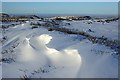
A Bronze Age round cairn or round barrow located on Bransdale Moor, circa 300m west of Round Hill in the northern part of the North York Moors National Park. The mound has 14m in diameter and is 0.8m high, on its top there is a modern stone structure.
Pastscape entry.
You may be viewing yesterday's version of this page. To see the most up to date information please register for a free account.
")
")
")
Do not use the above information on other web sites or publications without permission of the contributor.
Nearby Images from Geograph Britain and Ireland:

©2007(licence)
©2010(licence)

©2017(licence)

©2020(licence)

©2014(licence)
The above images may not be of the site on this page, they are loaded from Geograph.
Please Submit an Image of this site or go out and take one for us!
Click here to see more info for this site
Nearby sites
Key: Red: member's photo, Blue: 3rd party photo, Yellow: other image, Green: no photo - please go there and take one, Grey: site destroyed
Download sites to:
KML (Google Earth)
GPX (GPS waypoints)
CSV (Garmin/Navman)
CSV (Excel)
To unlock full downloads you need to sign up as a Contributory Member. Otherwise downloads are limited to 50 sites.
Turn off the page maps and other distractions
Nearby sites listing. In the following links * = Image available
298m E 93° Round Hill East* Round Barrow(s) (NZ59430159)
308m ESE 108° Hand Stone (Urra Moor)* Standing Stone (Menhir) (NZ5942701513)
563m SSW 212° North Gill Head (Urra Moor)* Rock Art (NZ5884101119)
577m ESE 107° Face Stone (Urra Moor)* Standing Stone (Menhir) (NZ5968701442)
864m NW 323° Carr Ridge Cairn (Urra Moor)* Cairn (NZ5859702283)
1.0km SSW 208° Collar Ridge Pillar Cairn* Cairn (NZ5866800700)
1.2km S 189° High Cable Stone (Tripsdale)* Natural Stone / Erratic / Other Natural Feature (NZ5896400446)
1.2km SSW 202° Collar Ridge Marker Stone* Marker Stone (NZ5868400435)
1.3km SSW 192° Upper Tripsdale Earthwork* Misc. Earthwork (NZ5887500296)
1.5km WNW 291° Cheshire Stone (Urra Moor)* Natural Stone / Erratic / Other Natural Feature (NZ5772902118)
1.5km SSW 194° Low Cable Stone (Tripsdale)* Natural Stone / Erratic / Other Natural Feature (NZ5878400147)
1.8km SE 133° Badger Stone (Todd Intake Moor)* Natural Stone / Erratic / Other Natural Feature (NZ6044500423)
1.9km WSW 241° Billy's Dyke* Misc. Earthwork (NZ5751300689)
2.1km ENE 71° Jenny Bradley Cross* Ancient Cross (NZ6112502309)
2.2km SSE 159° Crook Staff Hill* Round Barrow(s) (SE5993599584)
2.2km SE 146° Bransdale Moor Stone Circle Stone Circle (SE604998)
2.3km NE 46° Burton Howe* Round Barrow(s) (NZ60790325)
2.4km NE 44° Ingleby Greenhow Cairns* Round Cairn (NZ6078703333)
2.5km E 95° Rudland Rigg Guide Stone GS2* Marker Stone (NZ6161301430)
2.9km SSW 211° Black Intake Stone (Nab End Moor)* Marker Stone (SE5766099122)
2.9km SSW 199° Tripdale* Carving (SE5821098851)
2.9km NNE 27° Hand Stone (Ingleby Moor)* Marker Stone (NZ6041004222)
3.1km SSE 164° Slape Wath Moor Waymarkers* Marker Stone (SE6002998645)
3.1km SSW 198° Ship Stone (Tripsdale)* Natural Stone / Erratic / Other Natural Feature (SE5822698640)
3.4km SSW 207° Nan End Moor RB1 (Bilsdale)* Round Barrow(s) (SE5763398589)
View more nearby sites and additional images


 We would like to know more about this location. Please feel free to add a brief description and any relevant information in your own language.
 Wir möchten mehr über diese Stätte erfahren. Bitte zögern Sie nicht, eine kurze Beschreibung und relevante Informationen in Deutsch hinzuzufügen.
 Nous aimerions en savoir encore un peu sur les lieux. S'il vous plaît n'hesitez pas à ajouter une courte description et tous les renseignements pertinents dans votre propre langue.
 Quisieramos informarnos un poco más de las lugares. No dude en añadir una breve descripción y otros datos relevantes en su propio idioma.