


<< Our Photo Pages >> Hand Stone (Ingleby Moor) - Marker Stone in England in Yorkshire (North)
Submitted by johndhunter on Thursday, 26 October 2017 Page Views: 2152
Multi-periodSite Name: Hand Stone (Ingleby Moor)Country: England County: Yorkshire (North) Type: Marker Stone
Nearest Village: Ingleby Greenhowe
Map Ref: NZ6041004222
Latitude: 54.429843N Longitude: 1.07031W
Condition:
| 5 | Perfect |
| 4 | Almost Perfect |
| 3 | Reasonable but with some damage |
| 2 | Ruined but still recognisable as an ancient site |
| 1 | Pretty much destroyed, possibly visible as crop marks |
| 0 | No data. |
| -1 | Completely destroyed |
| 5 | Superb |
| 4 | Good |
| 3 | Ordinary |
| 2 | Not Good |
| 1 | Awful |
| 0 | No data. |
| 5 | Can be driven to, probably with disabled access |
| 4 | Short walk on a footpath |
| 3 | Requiring a bit more of a walk |
| 2 | A long walk |
| 1 | In the middle of nowhere, a nightmare to find |
| 0 | No data. |
| 5 | co-ordinates taken by GPS or official recorded co-ordinates |
| 4 | co-ordinates scaled from a detailed map |
| 3 | co-ordinates scaled from a bad map |
| 2 | co-ordinates of the nearest village |
| 1 | co-ordinates of the nearest town |
| 0 | no data |
Internal Links:
External Links:
 (PID:173017)")
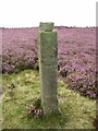
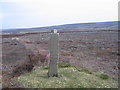
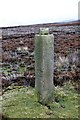
About half a mile to the north of Burton Howe just off to the east of the Cleveland Way is an old Guide Stone known as the Ingleby Moor Hand Stone. This section of what is now part of the Cleveland Way was at one time a major north / south route known as the Thurkilsti. It has the following Information carved on its East, West and South Faces. There is nothing on the North Face. Note: Because of erosion some of this lettering is now barely legible.
West Face (from top to bottom) TO INGLE BY AND STOX LEY
South Face (from top to bottom) TO KIRBY AND HEMS LEY 1757
East Face (from top to bottom) TO GIS BRO
Beneath the writing on both the west and east faces is a carved hand pointing north indicating the direction you must travel to reach the destination engraved on that face.
You may be viewing yesterday's version of this page. To see the most up to date information please register for a free account.
 (PID:173019)")
 (PID:173018)")
 (PID:173016)")
Do not use the above information on other web sites or publications without permission of the contributor.
Nearby Images from Geograph Britain and Ireland:
©2021(licence)
©2010(licence)
©2009(licence)
©2013(licence)
©2009(licence)
The above images may not be of the site on this page, they are loaded from Geograph.
Please Submit an Image of this site or go out and take one for us!
Click here to see more info for this site
Nearby sites
Key: Red: member's photo, Blue: 3rd party photo, Yellow: other image, Green: no photo - please go there and take one, Grey: site destroyed
Download sites to:
KML (Google Earth)
GPX (GPS waypoints)
CSV (Garmin/Navman)
CSV (Excel)
To unlock full downloads you need to sign up as a Contributory Member. Otherwise downloads are limited to 50 sites.
Turn off the page maps and other distractions
Nearby sites listing. In the following links * = Image available
651m NNW 344° Greenhow Road GS1* Marker Stone (NZ6022604847)
965m SSE 158° Ingleby Greenhow Cairns* Round Cairn (NZ6078703333)
1.0km SSE 159° Burton Howe* Round Barrow(s) (NZ60790325)
1.4km NE 55° Cheese Stones* Natural Stone / Erratic / Other Natural Feature (NZ6154405038)
1.5km NW 325° Mary Ross Seat* Carving (NZ5953405423)
1.9km NE 42° Baysdale Cross (Middle Head)* Ancient Cross (NZ6163205633)
2.0km SSE 160° Jenny Bradley Cross* Ancient Cross (NZ6112502309)
2.4km N 9° Battersby Bank Cross Dyke* Misc. Earthwork (NZ6075006650)
2.6km SW 224° Carr Ridge Cairn (Urra Moor)* Cairn (NZ5859702283)
2.7km NNE 13° Battersby Bank Round Barrow* Round Barrow(s) (NZ6099106907)
2.8km SSW 201° Round Hill East* Round Barrow(s) (NZ59430159)
2.8km SE 127° Job Cross (Stony Ridge - Stockdale Moor)* Marker Stone (NZ6268902564)
2.9km SSW 195° Face Stone (Urra Moor)* Standing Stone (Menhir) (NZ5968701442)
2.9km SSW 201° Hand Stone (Urra Moor)* Standing Stone (Menhir) (NZ5942701513)
2.9km SSW 207° Round Hill West* Cairn (NZ5913101602)
3.0km SSE 157° Rudland Rigg Guide Stone GS2* Marker Stone (NZ6161301430)
3.4km SW 233° Cheshire Stone (Urra Moor)* Natural Stone / Erratic / Other Natural Feature (NZ5772902118)
3.5km SSW 208° North Gill Head (Urra Moor)* Rock Art (NZ5884101119)
3.8km S 180° Badger Stone (Todd Intake Moor)* Natural Stone / Erratic / Other Natural Feature (NZ6044500423)
3.9km SSW 207° Collar Ridge Pillar Cairn* Cairn (NZ5866800700)
4.0km NE 50° Lamb Stone (Holiday Hill)* Natural Stone / Erratic / Other Natural Feature (NZ6343806835)
4.0km SSW 202° High Cable Stone (Tripsdale)* Natural Stone / Erratic / Other Natural Feature (NZ5896400446)
4.2km SSW 205° Collar Ridge Marker Stone* Marker Stone (NZ5868400435)
4.2km SSW 202° Upper Tripsdale Earthwork* Misc. Earthwork (NZ5887500296)
4.2km NNE 12° Warren Moor* Rock Art (NZ61240836)
View more nearby sites and additional images


 We would like to know more about this location. Please feel free to add a brief description and any relevant information in your own language.
 Wir möchten mehr über diese Stätte erfahren. Bitte zögern Sie nicht, eine kurze Beschreibung und relevante Informationen in Deutsch hinzuzufügen.
 Nous aimerions en savoir encore un peu sur les lieux. S'il vous plaît n'hesitez pas à ajouter une courte description et tous les renseignements pertinents dans votre propre langue.
 Quisieramos informarnos un poco más de las lugares. No dude en añadir una breve descripción y otros datos relevantes en su propio idioma.