

<< Our Photo Pages >> Mary Ross Seat - Carving in England in Yorkshire (North)
Submitted by johndhunter on Thursday, 06 July 2023 Page Views: 239
Modern SitesSite Name: Mary Ross SeatCountry: England County: Yorkshire (North) Type: Carving
Nearest Town: Stokesley Nearest Village: Ingleby Greenhowe
Map Ref: NZ5953405423
Latitude: 54.440738N Longitude: 1.08357W
Condition:
| 5 | Perfect |
| 4 | Almost Perfect |
| 3 | Reasonable but with some damage |
| 2 | Ruined but still recognisable as an ancient site |
| 1 | Pretty much destroyed, possibly visible as crop marks |
| 0 | No data. |
| -1 | Completely destroyed |
| 5 | Superb |
| 4 | Good |
| 3 | Ordinary |
| 2 | Not Good |
| 1 | Awful |
| 0 | No data. |
| 5 | Can be driven to, probably with disabled access |
| 4 | Short walk on a footpath |
| 3 | Requiring a bit more of a walk |
| 2 | A long walk |
| 1 | In the middle of nowhere, a nightmare to find |
| 0 | No data. |
| 5 | co-ordinates taken by GPS or official recorded co-ordinates |
| 4 | co-ordinates scaled from a detailed map |
| 3 | co-ordinates scaled from a bad map |
| 2 | co-ordinates of the nearest village |
| 1 | co-ordinates of the nearest town |
| 0 | no data |
Internal Links:
External Links:
")
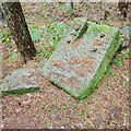
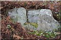
A few years ago now with only a six figure grid reference I had looked for it on several occasions when walking in this area with no luck. I only found it after I bumped into some forestry commission workers one day who showed me where it was.
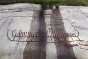
The engraving at the back of the seat says ‘Lady Mary Ross 1837’. Lady Mary who died in 1842 was the mother of Mary Foulis of Ingleby Manor which this seat overlooks though the view is obscured by the plantation trees.
Lady Mary Ross née Fitzgerald was the eldest daughter of the second Duke of Leinster* she married SIR CHARLES LOCKHART-ROSS in 1799. The family seat was the BALNAGOWN ESTATE near Invergordon in Scotland where she was mistress for forty three years. For twenty eight of those years after her husbands death in 1814 with her only surviving son being two years old she was effectively the Laird of Balnagown. According to a pamphlet produced by the Kirby, Great Broughton and Ingleby Greenhow local history group there is another Mary Ross Seat on this Estate overlooking the Balnagown River
*Today LEINSTER is the south eastern province of the Republic of Ireland (Eire) and is made of twelve counties including Dublin
You may be viewing yesterday's version of this page. To see the most up to date information please register for a free account.
")
")
Do not use the above information on other web sites or publications without permission of the contributor.
Nearby Images from Geograph Britain and Ireland:
©2005(licence)
©2008(licence)
©2008(licence)
©2021(licence)
©2009(licence)
The above images may not be of the site on this page, they are loaded from Geograph.
Please Submit an Image of this site or go out and take one for us!
Click here to see more info for this site
Nearby sites
Key: Red: member's photo, Blue: 3rd party photo, Yellow: other image, Green: no photo - please go there and take one, Grey: site destroyed
Download sites to:
KML (Google Earth)
GPX (GPS waypoints)
CSV (Garmin/Navman)
CSV (Excel)
To unlock full downloads you need to sign up as a Contributory Member. Otherwise downloads are limited to 50 sites.
Turn off the page maps and other distractions
Nearby sites listing. In the following links * = Image available
1.5km SE 145° Hand Stone (Ingleby Moor)* Marker Stone (NZ6041004222)
1.7km NE 45° Battersby Bank Cross Dyke* Misc. Earthwork (NZ6075006650)
2.0km ESE 102° Cheese Stones* Natural Stone / Erratic / Other Natural Feature (NZ6154405038)
2.1km NE 45° Battersby Bank Round Barrow* Round Barrow(s) (NZ6099106907)
2.1km E 85° Baysdale Cross (Middle Head)* Ancient Cross (NZ6163205633)
2.4km SSE 150° Ingleby Greenhow Cairns* Round Cairn (NZ6078703333)
2.5km SSE 151° Burton Howe* Round Barrow(s) (NZ60790325)
3.3km SSW 197° Carr Ridge Cairn (Urra Moor)* Cairn (NZ5859702283)
3.4km NNE 31° Warren Moor* Rock Art (NZ61240836)
3.5km SSE 154° Jenny Bradley Cross* Ancient Cross (NZ6112502309)
3.8km SSW 209° Cheshire Stone (Urra Moor)* Natural Stone / Erratic / Other Natural Feature (NZ5772902118)
3.8km S 182° Round Hill East* Round Barrow(s) (NZ59430159)
3.8km S 187° Round Hill West* Cairn (NZ5913101602)
3.9km S 182° Hand Stone (Urra Moor)* Standing Stone (Menhir) (NZ5942701513)
4.0km NE 53° Baysdale Pillar Cairn* Cairn (NZ6269407828)
4.0km S 179° Face Stone (Urra Moor)* Standing Stone (Menhir) (NZ5968701442)
4.1km WSW 244° The Wainstones* Rock Outcrop (NZ55880358)
4.1km WSW 245° The Wainstones 5* Rock Art (NZ5579303636)
4.1km ENE 71° Lamb Stone (Holiday Hill)* Natural Stone / Erratic / Other Natural Feature (NZ6343806835)
4.2km WSW 241° The Wainstones 6* Rock Art (NZ55840334)
4.2km SE 133° Job Cross (Stony Ridge - Stockdale Moor)* Marker Stone (NZ6268902564)
4.3km WSW 246° Broughton Bank WAI 1a* Rock Art (NZ5562603590)
4.4km S 190° North Gill Head (Urra Moor)* Rock Art (NZ5884101119)
4.4km WSW 244° The Wainstones 3* Rock Art (NZ5559203403)
4.5km SSE 153° Rudland Rigg Guide Stone GS2* Marker Stone (NZ6161301430)
View more nearby sites and additional images


 We would like to know more about this location. Please feel free to add a brief description and any relevant information in your own language.
 Wir möchten mehr über diese Stätte erfahren. Bitte zögern Sie nicht, eine kurze Beschreibung und relevante Informationen in Deutsch hinzuzufügen.
 Nous aimerions en savoir encore un peu sur les lieux. S'il vous plaît n'hesitez pas à ajouter une courte description et tous les renseignements pertinents dans votre propre langue.
 Quisieramos informarnos un poco más de las lugares. No dude en añadir una breve descripción y otros datos relevantes en su propio idioma.