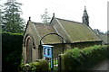
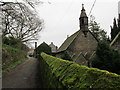
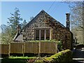
<< Our Photo Pages >> St Michael’s Church (Birchover) - Carving in England in Derbyshire
Submitted by Antonine on Friday, 18 November 2022 Page Views: 981
Multi-periodSite Name: St Michael’s Church (Birchover) Alternative Name: Rowtor ChapelCountry: England County: Derbyshire Type: Carving
Nearest Village: Birchover
Map Ref: SK23576210
Latitude: 53.155515N Longitude: 1.648985W
Condition:
| 5 | Perfect |
| 4 | Almost Perfect |
| 3 | Reasonable but with some damage |
| 2 | Ruined but still recognisable as an ancient site |
| 1 | Pretty much destroyed, possibly visible as crop marks |
| 0 | No data. |
| -1 | Completely destroyed |
| 5 | Superb |
| 4 | Good |
| 3 | Ordinary |
| 2 | Not Good |
| 1 | Awful |
| 0 | No data. |
| 5 | Can be driven to, probably with disabled access |
| 4 | Short walk on a footpath |
| 3 | Requiring a bit more of a walk |
| 2 | A long walk |
| 1 | In the middle of nowhere, a nightmare to find |
| 0 | No data. |
| 5 | co-ordinates taken by GPS or official recorded co-ordinates |
| 4 | co-ordinates scaled from a detailed map |
| 3 | co-ordinates scaled from a bad map |
| 2 | co-ordinates of the nearest village |
| 1 | co-ordinates of the nearest town |
| 0 | no data |
Be the first person to rate this site - see the 'Contribute!' box in the right hand menu.
Internal Links:
External Links:
 (PID:251572)")
The Saxons were the first to settle here. The original settlement, known as Uppertown, is half a mile to the south. The settlement moved to what is now Birchover when the population outgrew the water supply. There is no record of a church being at Uppertown but carved and dressed stones can be seen in the field boundary walls, including some stones decorated with Norman chevrons.
The Normans were the first to build a church at Birchover. The present church dates from c.1700. The walls of the church contain fragments of the Norman church, which can be seen from the outside. There are also Celtic heads incorporated in the walls of the church. These probably date back to the Brigantes tribe.
You may be viewing yesterday's version of this page. To see the most up to date information please register for a free account.
 (PID:251574)")
 (PID:251573)")
Do not use the above information on other web sites or publications without permission of the contributor.
Nearby Images from Geograph Britain and Ireland:

©2011(licence)
©2013(licence)
©2014(licence)
©2022(licence)

©2023(licence)
The above images may not be of the site on this page, they are loaded from Geograph.
Please Submit an Image of this site or go out and take one for us!
Click here to see more info for this site
Nearby sites
Key: Red: member's photo, Blue: 3rd party photo, Yellow: other image, Green: no photo - please go there and take one, Grey: site destroyed
Download sites to:
KML (Google Earth)
GPX (GPS waypoints)
CSV (Garmin/Navman)
CSV (Excel)
To unlock full downloads you need to sign up as a Contributory Member. Otherwise downloads are limited to 50 sites.
Turn off the page maps and other distractions
Nearby sites listing. In the following links * = Image available
30m E 90° The Megalithic Portal Live in the Derbyshire Peak District Natural Stone / Erratic / Other Natural Feature (SK236621)
54m NNW 339° Rowtor Rocks* Rock Art (SK23556215)
351m W 265° Rockingstone Farm* Rock Outcrop (SK2322062065)
815m NNE 19° Doll Tor* Stone Circle (SK2383062873)
890m WNW 283° Cratcliff Rocks* Hillfort (SK227623)
1.0km NNE 28° Andle Stone (Stanton Moor)* Natural Stone / Erratic / Other Natural Feature (SK2403162993)
1.0km NE 46° Stanton Moor Cairn T14* Cairn (SK24306281)
1.0km NE 49° Cork Stone* Natural Stone / Erratic / Other Natural Feature (SK2434662788)
1.0km WNW 286° Robin Hoods Settlement* Ancient Village or Settlement (SK22576238)
1.1km NE 43° Stanton Moor Cairn T13* Round Cairn (SK243629)
1.1km W 278° Robin Hood's Stride* Rock Art (SK22476225)
1.1km WNW 286° Robin Hood's Stride* Rock Outcrop (SK225624)
1.2km WNW 298° Nine Stones Close* Stone Circle (SK2253762643)
1.2km W 265° Dudwood* Stone Circle (SK224620)
1.3km NW 306° Nine Stones Cup Mark (Harthill) Rock Art (SK22546284)
1.3km NW 307° Harthill Cairn* Cairn (SK22556286)
1.3km ENE 58° Stanton Moor Cairn (TBC)* Cairn (SK2467562791)
1.4km NE 51° Stanton Moor Cairn T25* Cairn (SK24656297)
1.4km NE 55° Stanton Moor 4* Ring Cairn (SK24716290)
1.6km NE 51° Stanton Moor Cairn T55* Round Cairn (SK24826313)
1.6km WNW 296° Castle Ring (Derbyshire)* Hillfort (SK221628)
1.7km NE 47° Stanton Moor 3* Stone Circle (SK24806326)
1.7km ENE 63° Gorse Stone* Rock Outcrop (SK251629)
1.7km NE 45° Stanton Moor Cairn T24* Cairn (SK24806333)
1.9km NE 44° The King (Stanton Moor)* Standing Stone (Menhir) (SK24876347)
View more nearby sites and additional images


 We would like to know more about this location. Please feel free to add a brief description and any relevant information in your own language.
 Wir möchten mehr über diese Stätte erfahren. Bitte zögern Sie nicht, eine kurze Beschreibung und relevante Informationen in Deutsch hinzuzufügen.
 Nous aimerions en savoir encore un peu sur les lieux. S'il vous plaît n'hesitez pas à ajouter une courte description et tous les renseignements pertinents dans votre propre langue.
 Quisieramos informarnos un poco más de las lugares. No dude en añadir una breve descripción y otros datos relevantes en su propio idioma.