 with our Megalithic Portal iPhone app")


<< Our Photo Pages >> Cranes Fort - Hillfort in England in Derbyshire
Submitted by vicky on Thursday, 09 January 2003 Page Views: 8257
Iron Age and Later PrehistorySite Name: Cranes FortCountry: England County: Derbyshire Type: Hillfort
Nearest Town: Bakewell Nearest Village: Youlgreave
Map Ref: SK203659 Landranger Map Number: 119
Latitude: 53.189806N Longitude: 1.697644W
Condition:
| 5 | Perfect |
| 4 | Almost Perfect |
| 3 | Reasonable but with some damage |
| 2 | Ruined but still recognisable as an ancient site |
| 1 | Pretty much destroyed, possibly visible as crop marks |
| 0 | No data. |
| -1 | Completely destroyed |
| 5 | Superb |
| 4 | Good |
| 3 | Ordinary |
| 2 | Not Good |
| 1 | Awful |
| 0 | No data. |
| 5 | Can be driven to, probably with disabled access |
| 4 | Short walk on a footpath |
| 3 | Requiring a bit more of a walk |
| 2 | A long walk |
| 1 | In the middle of nowhere, a nightmare to find |
| 0 | No data. |
| 5 | co-ordinates taken by GPS or official recorded co-ordinates |
| 4 | co-ordinates scaled from a detailed map |
| 3 | co-ordinates scaled from a bad map |
| 2 | co-ordinates of the nearest village |
| 1 | co-ordinates of the nearest town |
| 0 | no data |
Internal Links:
External Links:
")
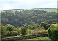
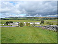
Cranes Fort is located at Conksbury, on a long limestone ridge at 233m (764ft) above sea level, to the north-east of Meadow Place Grange Farm, almost half way between Fin Cop and Castle Ring. The possibility of a fort here was first suggested in the 1950s, but only confirmed after an investigation in 1989.
Enclosing a sub-rectangular area of just under 4 hectares (10 acres), the defences consist of a single rampart composed of limestone blocks, infilled with rubble. The fort is protected by a low wall to the north and south where the ground is naturally steep, whilst to the east and west the ramparts are more substantial. Today most of the defences are hidden under enclosure walls and the site is badly damaged following intensive stone robbing and years of ploughing in the area.
You may be viewing yesterday's version of this page. To see the most up to date information please register for a free account.
Do not use the above information on other web sites or publications without permission of the contributor.
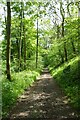
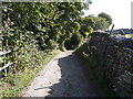
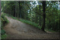
Nearby Images from Geograph Britain and Ireland:
©2011(licence)
©2023(licence)
©2007(licence)
©2007(licence)
©2009(licence)
The above images may not be of the site on this page, they are loaded from Geograph.
Please Submit an Image of this site or go out and take one for us!
Click here to see more info for this site
Nearby sites
Key: Red: member's photo, Blue: 3rd party photo, Yellow: other image, Green: no photo - please go there and take one, Grey: site destroyed
Download sites to:
KML (Google Earth)
GPX (GPS waypoints)
CSV (Garmin/Navman)
CSV (Excel)
To unlock full downloads you need to sign up as a Contributory Member. Otherwise downloads are limited to 50 sites.
Turn off the page maps and other distractions
Nearby sites listing. In the following links * = Image available
749m S 180° Back Lane Cairn Circle Ring Cairn (SK2030365151)
1.3km ESE 115° Haddon Fields Bowl Barrow 1* Round Barrow(s) (SK21486535)
1.4km E 79° Haddon Fields Bowl Barrow 2* Round Barrow(s) (SK21726617)
1.6km SW 224° Bee Lowe Round Cairn (SK19166473)
1.8km SSE 150° All Saints Church (Youlgreave)* Carving (SK21206437)
2.0km WSW 255° Calling Low Dale* Cave or Rock Shelter (SK184654)
2.7km NW 312° Bole Hill Bowl Barrow* Round Barrow(s) (SK18286771)
2.8km NE 40° St Peter's Well (Bakewell)* Holy Well or Sacred Spring (SK2209768025)
2.8km NNE 26° Bakewell Churchyard* Ancient Cross (SK2154768458)
3.0km W 264° One Ash Shelter* Cave or Rock Shelter (SK17266559)
3.1km NNE 29° Bath House Spring* Holy Well or Sacred Spring (SK218686)
3.3km S 184° Larks Low Bowl Barrow* Round Barrow(s) (SK20086260)
3.4km W 279° Ringham Low* Chambered Cairn (SK169664)
3.6km SSE 150° Castle Ring (Derbyshire)* Hillfort (SK221628)
3.7km NW 319° Sheldon Henge* Henge (SK1788068650)
3.8km SE 144° Harthill Cairn* Cairn (SK22556286)
3.8km SSW 199° Rusden Lowe Round Barrow(s) (SK19116231)
3.8km SE 144° Nine Stones Cup Mark (Harthill) Rock Art (SK22546284)
3.9km SE 146° Nine Stones Close* Stone Circle (SK2253762643)
4.0km WSW 248° Cales Dale* Round Barrow(s) (SK16636437)
4.0km N 355° Sheepwash Well Holy Well or Sacred Spring (SK199699)
4.1km NE 38° Ball Cross* Hillfort (SK228691)
4.2km SSE 147° Robin Hoods Settlement* Ancient Village or Settlement (SK22576238)
4.2km NE 52° Calton Pasture* Round Barrow(s) (SK236685)
4.2km SSE 150° Robin Hood's Stride* Rock Outcrop (SK22446228)
View more nearby sites and additional images


 We would like to know more about this location. Please feel free to add a brief description and any relevant information in your own language.
 Wir möchten mehr über diese Stätte erfahren. Bitte zögern Sie nicht, eine kurze Beschreibung und relevante Informationen in Deutsch hinzuzufügen.
 Nous aimerions en savoir encore un peu sur les lieux. S'il vous plaît n'hesitez pas à ajouter une courte description et tous les renseignements pertinents dans votre propre langue.
 Quisieramos informarnos un poco más de las lugares. No dude en añadir una breve descripción y otros datos relevantes en su propio idioma.