<< Our Photo Pages >> Crosland Moor Holy Well - Holy Well or Sacred Spring in England in Yorkshire (West)
Submitted by andy_h on Thursday, 03 June 2004 Page Views: 19115
Springs and Holy WellsSite Name: Crosland Moor Holy WellCountry: England County: Yorkshire (West) Type: Holy Well or Sacred Spring
Nearest Town: Huddersfield Nearest Village: Crosland Moor
Map Ref: SE121156 Landranger Map Number: 110
Latitude: 53.636782N Longitude: 1.818476W
Condition:
| 5 | Perfect |
| 4 | Almost Perfect |
| 3 | Reasonable but with some damage |
| 2 | Ruined but still recognisable as an ancient site |
| 1 | Pretty much destroyed, possibly visible as crop marks |
| 0 | No data. |
| -1 | Completely destroyed |
| 5 | Superb |
| 4 | Good |
| 3 | Ordinary |
| 2 | Not Good |
| 1 | Awful |
| 0 | No data. |
| 5 | Can be driven to, probably with disabled access |
| 4 | Short walk on a footpath |
| 3 | Requiring a bit more of a walk |
| 2 | A long walk |
| 1 | In the middle of nowhere, a nightmare to find |
| 0 | No data. |
| 5 | co-ordinates taken by GPS or official recorded co-ordinates |
| 4 | co-ordinates scaled from a detailed map |
| 3 | co-ordinates scaled from a bad map |
| 2 | co-ordinates of the nearest village |
| 1 | co-ordinates of the nearest town |
| 0 | no data |
Internal Links:
External Links:
I have visited· I would like to visit
Oakey76uk would like to visit
")
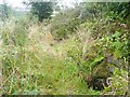
Whilst looking over old Ordinance Survey maps, I have found what I believe to be a forgotten Holy Well. When I was a child, we used to call it the 'Wishing Well'. On the hillside of Crosland Moor above Manchester Road is a small spring that we used to take our water from during the drought in 1976 and drink from after playing footy on the nearby recreation field.
It doesn't look like a significant site now but from the evidence that I can find, it may once have been quite a special place. It is reached either by leaving the path leading to the old quarries from the top junction of Ivy Street and William Street, and taking the steep path down to the steps that lead to the well. Or by taking the path opposite the graveyard entrance on Deep Lane and walking up the hill behind the Warren House and on to the well.
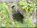
Water emerged from the hillside via a crudely cemented pipe into a small pool. It was then directed out by an open stone gutter, across the path and into a trough constructed from sandstone slabs. Out of the trough, it tumbles down the hill side, past a small rock outcrop to be collected in a tank behind houses on Manchester Road.
Next to the trough is a curious stone box, open only on the side overlooking the valley in which Milnsbridge sits and looking over to Paddock and Golcar. The place has changed a bit since I was a boy. The old stone gutter has gone, the water now flows into a round concrete bowl and disappears underground. The old trough lies broken and overgrown by brambles and a low section of stone walling has been built behind the well recently.
As the hillside around this area has been worked as quarries in the past (Crosland Moor sandstone is of noted quality and was used in a number of local buildings), it is possible that the steps and trough may be associated with the quarry works, or possibly a trough for local people to draw water from before the laying of water pipes. Troughs also still exist at the bottom of the Pinfold Lane/Manchester Road junction and on Deep Lane. I thought little of the well in the years during which I grew up and moved away from the area. However, I was recently looking over an 1843 Ordinance Survey map of the area when I noticed that the hillside was known as Holy Well Woods at the time. This fired my curiosity and examination of a more detailed map from 1854 shows that the Holy Well in question, is the stream that we used to call the 'Wishing Well'. Is it possible that the name 'Holy Well' is a christianisation of a much earlier name? Is it possible that it may have been a significant site during the iron age practise of water worship? Unfortunately the site itself doesn't offer many visible clues and I don't remember hearing any folktales attached to the well.
You may be viewing yesterday's version of this page. To see the most up to date information please register for a free account.
")
")
")
Do not use the above information on other web sites or publications without permission of the contributor.
Nearby Images from Geograph Britain and Ireland:
©2009(licence)
©2009(licence)
©2007(licence)
©2018(licence)
©2021(licence)
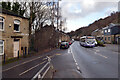
The above images may not be of the site on this page, they are loaded from Geograph.
Please Submit an Image of this site or go out and take one for us!
Click here to see more info for this site
Nearby sites
Key: Red: member's photo, Blue: 3rd party photo, Yellow: other image, Green: no photo - please go there and take one, Grey: site destroyed
Download sites to:
KML (Google Earth)
GPX (GPS waypoints)
CSV (Garmin/Navman)
CSV (Excel)
To unlock full downloads you need to sign up as a Contributory Member. Otherwise downloads are limited to 50 sites.
Turn off the page maps and other distractions
Nearby sites listing. In the following links * = Image available
3.5km ESE 115° Castle Hill (West Yorkshire)* Hillfort (SE153141)
4.4km W 279° Whole Stone (Golcar) Natural Stone / Erratic / Other Natural Feature (SE077163)
4.5km W 279° Rocking Stone (Golcar) Natural Stone / Erratic / Other Natural Feature (SE076163)
4.6km NW 314° St Helen's Well (Stainland) Holy Well or Sacred Spring (SE088188)
5.3km WSW 253° Slaithwaite Cross Ancient Cross (SE0714)
5.9km SSE 151° Hagg Woods (Thongsbridge) Cairn (SE1493410443)
6.2km NNE 16° St Matthew (Rastrick)* Ancient Cross (SE1383121596)
6.4km SSW 211° Oldfield Hill (Meltham) Ancient Village or Settlement (SE0874510097)
7.3km WNW 285° Meg Dike Ancient Village or Settlement (SE04981749)
7.8km SW 218° Rocking Stone (Meltham Moor) Natural Stone / Erratic / Other Natural Feature (SE07280944)
8.1km WSW 240° Samuel Laycock's Monument (Marsden)* Carving (SE0512011485)
8.1km WNW 289° Ringstone Edge* Stone Circle (SE0443518251)
8.1km SSW 213° West Nab* Rock Outcrop (SE07670880)
8.8km NNW 342° Shaw Hill (Skircoat) Cairn (SE09372401)
9.8km NE 36° Lady Well (Hartshead) Holy Well or Sacred Spring (SE1788423487)
9.9km NE 34° The Walton Cross* Ancient Cross (SE1761423792)
10.3km WSW 240° Pule Hill (Marsden) Cairn (SE03231039)
10.4km WSW 238° Mount Rd stone* Marker Stone (SE033101)
10.5km NNW 342° Stannary (Halifax) Stone Circle (SE088256)
10.7km NE 46° Fairy Well (Roberttown)* Holy Well or Sacred Spring (SE19812308)
10.8km N 6° Priestly Green Holy Well Holy Well or Sacred Spring (SE13202632)
10.8km WSW 255° March Hill Mesolithic Camp Ancient Village or Settlement (SE0163612804)
11.3km NNW 328° Warley Edge (Halifax)* Rock Art (SE061252)
11.5km SSW 204° Black Hill Cairn (SE074051)
12.1km SSW 207° Holgate Howe Barrow Round Barrow(s) (SE067048)
View more nearby sites and additional images


 We would like to know more about this location. Please feel free to add a brief description and any relevant information in your own language.
 Wir möchten mehr über diese Stätte erfahren. Bitte zögern Sie nicht, eine kurze Beschreibung und relevante Informationen in Deutsch hinzuzufügen.
 Nous aimerions en savoir encore un peu sur les lieux. S'il vous plaît n'hesitez pas à ajouter une courte description et tous les renseignements pertinents dans votre propre langue.
 Quisieramos informarnos un poco más de las lugares. No dude en añadir una breve descripción y otros datos relevantes en su propio idioma.