

<< Our Photo Pages >> Oxenham Arms - Standing Stone (Menhir) in England in Devon
Submitted by TheCaptain on Thursday, 03 June 2004 Page Views: 15306
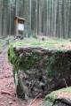
Neolithic and Bronze AgeSite Name: Oxenham ArmsCountry: England County: Devon Type: Standing Stone (Menhir)
Nearest Town: Okehampton Nearest Village: South Zeal
Map Ref: SX65119354 Landranger Map Number: 191
Latitude: 50.725778N Longitude: 3.912478W
Condition:
| 5 | Perfect |
| 4 | Almost Perfect |
| 3 | Reasonable but with some damage |
| 2 | Ruined but still recognisable as an ancient site |
| 1 | Pretty much destroyed, possibly visible as crop marks |
| 0 | No data. |
| -1 | Completely destroyed |
| 5 | Superb |
| 4 | Good |
| 3 | Ordinary |
| 2 | Not Good |
| 1 | Awful |
| 0 | No data. |
| 5 | Can be driven to, probably with disabled access |
| 4 | Short walk on a footpath |
| 3 | Requiring a bit more of a walk |
| 2 | A long walk |
| 1 | In the middle of nowhere, a nightmare to find |
| 0 | No data. |
| 5 | co-ordinates taken by GPS or official recorded co-ordinates |
| 4 | co-ordinates scaled from a detailed map |
| 3 | co-ordinates scaled from a bad map |
| 2 | co-ordinates of the nearest village |
| 1 | co-ordinates of the nearest town |
| 0 | no data |
Internal Links:
External Links:
I have visited· I would like to visit
whese001 hallsifer would like to visit
Anne T visited on 13th May 2019 - their rating: Cond: 3 Amb: 4 Access: 4 Oxenham Arms Menhir & Roman Stone: We originally headed off to the wrong pub, at the north western end of the village, but having thought the name of the pub wasn't what we remembered, we found the Oxenham Arms just down the hill from the village cross.
Walking into the pub from the bright sunshine of the street took my eyes some time to adjust, but we welcomed the coolness and the opportunity of a long, cold, icy drink.
I asked the barman if I could ask a cheeky question, and he said “on the scale of 1 to 10, how cheeky?” I replied “4”. He said “that’s not cheeky”. He very patiently told us where to find the standing stone, and also told us about the Roman pillar in the restaurant at the back. He very kindly said it was OK for me to take photos.
He also added (tongue in cheek?) that they thought it had taken 40 years to carve the granite standing stone, although how he knew, I don’t know. The stone apparently continues in one of the rooms upstairs.
Lovely atmosphere here. If we go back to Devon, I’d like to go for a meal here. A chance to see a couple of fine stones and have a drink at the same time - only the second time ever (the first being at the Templar Preceptory at Rothley).
There are several notices hanging on the wall and I’ve typed this up.
Catrinm visited on 11th Feb 2019 - their rating: Cond: 4 Amb: 5 Access: 5 25 ft stone 4 feet into room above and 17 ft underground
graemefield visited on 4th May 2014 - their rating: Cond: 4 Amb: 4 Access: 5
RSleepy visited on 1st Jan 1989 - their rating: Cond: 5 Amb: 5 Access: 5 Nice pub - the megalith is original feature
AngieLake TheCaptain cazzyjane have visited here
Average ratings for this site from all visit loggers: Condition: 4 Ambience: 4.5 Access: 4.75
")
As the pub website says "A very interesting part of the house is the small lounge behind the bar. In this room, set in the wall, is a monolith and the theory of archaeologists is that the monastic builders placed their house around this prehistoric stone shaped by man 5,000 years ago. Notwithstanding deep digging, its foundations have never been reached".
This is one stone which is still very much enjoying life !
Update November 2019: This menhir is recorded as Pastscape Monument No. 444099, as MDV13065 (The Oxenham Arms, South Zeal) on the Devon and Dartmoor HER, and scheduled as part of Historic England List ID 1305729 (The Oxenham Arms).
This standing stone is also featured on the Prehistoric Dartmoor Walks (PDW) website - see their entry for the Oxenham Arms Standing Stone.
As well as the menhir in the snug, there is also a 'Roman Pillar' propping up the roof in the restaurant at the rear of the pub.
You may be viewing yesterday's version of this page. To see the most up to date information please register for a free account.
")
")
")
")
")
")
")
")
")
")
")
")
")
Do not use the above information on other web sites or publications without permission of the contributor.
Click here to see more info for this site
Nearby sites
Key: Red: member's photo, Blue: 3rd party photo, Yellow: other image, Green: no photo - please go there and take one, Grey: site destroyed
Download sites to:
KML (Google Earth)
GPX (GPS waypoints)
CSV (Garmin/Navman)
CSV (Excel)
To unlock full downloads you need to sign up as a Contributory Member. Otherwise downloads are limited to 50 sites.
Turn off the page maps and other distractions
Nearby sites listing. In the following links * = Image available
76m NW 314° South Zeal Cross* Ancient Cross (SX6505793594)
440m S 180° Ramsley Stone Row / Alignment (SX651931)
459m SW 221° South Zeal Stone Row* Stone Row / Alignment (SX648932)
602m NNE 12° Moon's Cross* Ancient Cross (SX6525194125)
1.0km N 8° St Andrew's Cross (South Tawton)* Ancient Cross (SX65289453)
1.0km SSE 148° West Wyke Farm Cross* Ancient Cross (SX6564692638)
1.1km SSE 146° West Wykes Farm Tau and Latin Crosses* Ancient Cross (SX6567992638)
1.2km WNW 295° Sticklepath Methodist Chapel Cross* Ancient Cross (SX6404694079)
1.2km SSW 209° Eight Rocks* Stone Circle (SX645925)
1.3km WNW 294° Lady Well (Sticklepath)* Holy Well or Sacred Spring (SX6390494124)
1.4km WNW 295° Sticklepath Boundary Marker* Marker Stone (SX6388694135)
1.4km NE 51° Oxenham Cross* Ancient Cross (SX6625194414)
1.6km E 96° Addiscott Cross* Ancient Cross (SX6666993344)
1.7km ENE 58° Ring Hill Cross* Ancient Cross (SX66559440)
1.9km WSW 240° Sticklepath stone circle* Stone Circle (SX63439264)
2.0km WSW 237° Cosdon Hill cairn 9* Round Cairn (SX63419250)
2.1km SSW 200° Cosdon Hill Multiple Stone Rows* Multiple Stone Rows / Avenue (SX64349159)
2.1km SSW 200° Cosdon Hill Cairn Circle* Stone Circle (SX64339159)
2.2km ENE 72° Ringhole Copse Cross* Ancient Cross (SX6721794162)
2.3km WNW 301° Belstone Boundary Marker* Marker Stone (SX6314994770)
2.5km SW 215° Cosdon Hill Summit Cairns* Cairn (SX63619149)
2.8km SSE 165° Throwleigh Common prehistoric settlement and field system* Ancient Village or Settlement (SX65779078)
3.1km W 267° Holy Well (Belstone)* Holy Well or Sacred Spring (SX6202393468)
3.2km W 268° Belstone Ring Cross* Ancient Cross (SX6192793500)
3.4km SSE 165° Higher Shilstone Hut Circle* Ancient Village or Settlement (SX659902)
View more nearby sites and additional images


 We would like to know more about this location. Please feel free to add a brief description and any relevant information in your own language.
 Wir möchten mehr über diese Stätte erfahren. Bitte zögern Sie nicht, eine kurze Beschreibung und relevante Informationen in Deutsch hinzuzufügen.
 Nous aimerions en savoir encore un peu sur les lieux. S'il vous plaît n'hesitez pas à ajouter une courte description et tous les renseignements pertinents dans votre propre langue.
 Quisieramos informarnos un poco más de las lugares. No dude en añadir una breve descripción y otros datos relevantes en su propio idioma.