<< Other Photo Pages >> West Kennet Palisaded Enclosures - Ancient Village or Settlement in England in Wiltshire
Submitted by Andy B on Saturday, 23 November 2024 Page Views: 8326
Neolithic and Bronze AgeSite Name: West Kennet Palisaded Enclosures Alternative Name: West Kennet Palisade EnclosuresCountry: England County: Wiltshire Type: Ancient Village or Settlement
Map Ref: SU110682
Latitude: 51.412715N Longitude: 1.843223W
Condition:
| 5 | Perfect |
| 4 | Almost Perfect |
| 3 | Reasonable but with some damage |
| 2 | Ruined but still recognisable as an ancient site |
| 1 | Pretty much destroyed, possibly visible as crop marks |
| 0 | No data. |
| -1 | Completely destroyed |
| 5 | Superb |
| 4 | Good |
| 3 | Ordinary |
| 2 | Not Good |
| 1 | Awful |
| 0 | No data. |
| 5 | Can be driven to, probably with disabled access |
| 4 | Short walk on a footpath |
| 3 | Requiring a bit more of a walk |
| 2 | A long walk |
| 1 | In the middle of nowhere, a nightmare to find |
| 0 | No data. |
| 5 | co-ordinates taken by GPS or official recorded co-ordinates |
| 4 | co-ordinates scaled from a detailed map |
| 3 | co-ordinates scaled from a bad map |
| 2 | co-ordinates of the nearest village |
| 1 | co-ordinates of the nearest town |
| 0 | no data |
Internal Links:
External Links:
I have visited· I would like to visit
mdensham has visited here

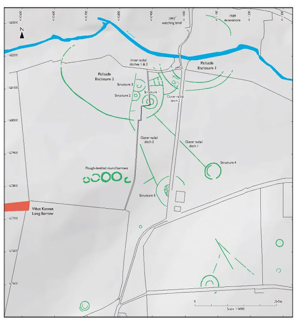
“Palisade Enclosure 1” has been confirmed as having two concentric ditches enclosing an approximately circular area over 200m across. Test trenches have revealed that these ditches held oak posts forming a dense timber palisade. They rotted in situ, and may have been burned. Animal deposits had been placed at the bases of some of the posts. An intriguing feature of this enclosure is that the River Kennet cuts right through its centre – it was built over the river.
Only part of one ditch of Palisade Enclosure 2 has so far been located, but this, too, contained timber posts. Within the circuit of the ditch, however, there were two smaller concentric circular ditches belonging to a former timber building 40m in diameter. Air photos and magnetometer surveys show some straight crop markings associated with the second palisaded enclosure: these seem to have been linear palisades. One connects to another circular marking (‘Structure 4’) over 200m away.
An intriguing solar phenomenon involving Silbury Hill can be observed from the Palisades (see “Visual Investigations”).
Source: Landscape Perception
These enclosures were built in the flat lower area between West Kennet long barrow, Overton Hill and Waden Hill. The erection consisted of two major enclosures of oak posts up to around 5m high with smaller enclosures within and several outer radial alignments, the longest of which had a further enclosure at its far end. Six radiocarbon dates are available for the West Kennet palisade enclosures giving a range of 2860-1890 BC. Despite this large range, it is probable that the enclosures stood for only a limited time, perhaps little more than 100 years, as no maintenance work is apparent and the oak posts may have been deliberately burnt before they could rot. Whittle (1997) suggests that the enclosures may have been linked with the building of Silbury Hill.
Source: Digital Avebury: New 'Avenues' of Research - Simon R. Davies, Internet Archaeology Issue 27 (2009)
Earlier date for ancient wooden structures in West Kennet, see the comment on our page
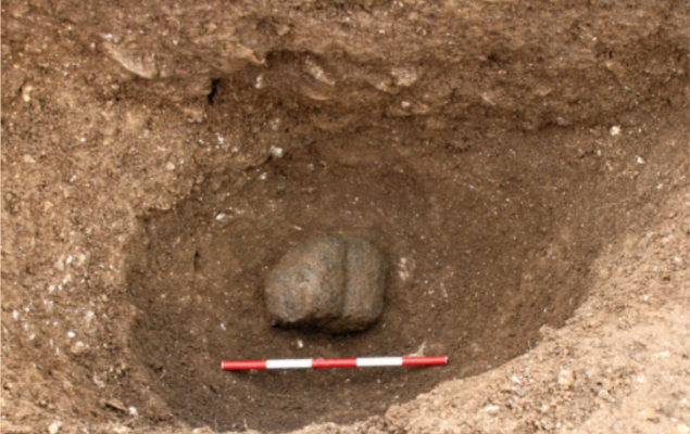
Note: 77 lumps of weathered granodiorite (~granite) were found in the remains of a large timber structure and in Bronze Age graves near West Kennet, Avebury. Samples of these rocks have now been confirmed by the usual amazing 'rock detectives' of Ixer, Bevins et al as originating from around Cunyan Crags or Threestoneburn stone circle close to the Cheviot Hills in NE England. Examination indicates they were collected from a single highly weathered outcrop rather than random (very rare) glacial sources. Then taken south for ~450km - twice as far as the bluestones’ journey to Stonehenge? (but not as far as the Altar stone ) These are "especially unusual and distinctive" rocks and do appear to have been selected and intentionally placed in the structures at West Kennet. Were 77 chunks (22kg) of rough and not very impressive old rock - see pics - and these are the good ones - carried all this distance for a purpose? It seems almost incomprehensible to modern eyes what this may have been. Rest assured the archaeologists are not baffled but the rest of us might be. What was going on? Everyone is intrigued. More to follow. Follow the comments on this page and the rather lovely Threestoneburn circle is here
You may be viewing yesterday's version of this page. To see the most up to date information please register for a free account.


Do not use the above information on other web sites or publications without permission of the contributor.
Nearby Images from Geograph Britain and Ireland:

©2022(licence)

©2014(licence)

©2016(licence)
![SU1068 : A circular walk on the Downs from Avebury [76] by Michael Dibb](https://s0.geograph.org.uk/geophotos/06/47/47/6474712_4dccb565_120x120.jpg)
©2020(licence)
![SU1068 : A circular walk on the Downs from Avebury [77] by Michael Dibb](https://s3.geograph.org.uk/geophotos/06/47/47/6474715_2a888ce0_120x120.jpg)
©2020(licence)
The above images may not be of the site on this page, they are loaded from Geograph.
Please Submit an Image of this site or go out and take one for us!
Click here to see more info for this site
Nearby sites
Key: Red: member's photo, Blue: 3rd party photo, Yellow: other image, Green: no photo - please go there and take one, Grey: site destroyed
Download sites to:
KML (Google Earth)
GPX (GPS waypoints)
CSV (Garmin/Navman)
CSV (Excel)
To unlock full downloads you need to sign up as a Contributory Member. Otherwise downloads are limited to 50 sites.
Turn off the page maps and other distractions
Nearby sites listing. In the following links * = Image available
404m WNW 293° Silbaby* Misc. Earthwork (SU1062668354)
674m NE 50° Overton Hill barrow cemetery* Barrow Cemetery (SU11526863)
678m SW 227° West Kennett Long Barrow* Long Barrow (SU10506774)
823m WSW 247° West Kennet Barrow* Round Barrow(s) (SU10246788)
847m ESE 102° The Sanctuary.* Stone Circle (SU11836802)
903m W 264° Swallowhead Spring* Holy Well or Sacred Spring (SU101681)
958m E 93° The Sanctuary Barrows* Barrow Cemetery (SU11966816)
1.0km WNW 289° Silbury Hill* Artificial Mound (SU10016853)
1.1km N 359° Falkner's Circle* Stone Circle (SU10986931)
1.1km NNW 344° West Kennet Avenue* Multiple Stone Rows / Avenue (SU10696928)
1.3km NNW 341° West Kennet Avenue polisher* Polissoir (SU10576947)
1.5km SE 134° East Kennett garden feature* Modern Stone Circle etc (SU12066720)
1.5km SSE 155° East Kennett longbarrow* Long Barrow (SU11636684)
1.6km SW 227° Beckhampton Penning circle* Stone Circle (SU09876713)
1.8km S 171° Harestone Down* Stone Circle (SU113664)
1.9km NNW 328° Alexander Keiller Museum* Museum (SU100698)
1.9km NNW 337° Avebury* Stone Circle (SU10266996)
1.9km WSW 238° Beckhampton Penning barrows Barrow Cemetery (SU09356717)
2.0km NNW 338° Avebury - The Cove* Standing Stones (SU10257002)
2.0km NNW 330° St. James's Church (Avebury) Ancient Cross (SU0997669968)
2.1km NNE 25° Avebury Down barrow cemetery* Barrow Cemetery (SU11877007)
2.1km S 177° Harestone Down Tumulus* Round Barrow(s) (SU1111766058)
2.3km WNW 298° South Street Long Barrow* Chambered Tomb (SU09006927)
2.3km ENE 57° Down Barn* Standing Stones (SU12966949)
2.4km WNW 298° Longstone Cove* Standing Stones (SU0888769301)
View more nearby sites and additional images


 We would like to know more about this location. Please feel free to add a brief description and any relevant information in your own language.
 Wir möchten mehr über diese Stätte erfahren. Bitte zögern Sie nicht, eine kurze Beschreibung und relevante Informationen in Deutsch hinzuzufügen.
 Nous aimerions en savoir encore un peu sur les lieux. S'il vous plaît n'hesitez pas à ajouter une courte description et tous les renseignements pertinents dans votre propre langue.
 Quisieramos informarnos un poco más de las lugares. No dude en añadir una breve descripción y otros datos relevantes en su propio idioma.