


<< Our Photo Pages >> Tan Hill Stone Circle - Modern Stone Circle etc in England in Wiltshire
Submitted by teslacoil on Monday, 08 April 2013 Page Views: 7551
Neolithic and Bronze AgeSite Name: Tan Hill Stone CircleCountry: England County: Wiltshire Type: Modern Stone Circle etc
Nearest Town: Devizes Nearest Village: All Cannings
Map Ref: SU079643
Latitude: 51.377699N Longitude: 1.887883W
Condition:
| 5 | Perfect |
| 4 | Almost Perfect |
| 3 | Reasonable but with some damage |
| 2 | Ruined but still recognisable as an ancient site |
| 1 | Pretty much destroyed, possibly visible as crop marks |
| 0 | No data. |
| -1 | Completely destroyed |
| 5 | Superb |
| 4 | Good |
| 3 | Ordinary |
| 2 | Not Good |
| 1 | Awful |
| 0 | No data. |
| 5 | Can be driven to, probably with disabled access |
| 4 | Short walk on a footpath |
| 3 | Requiring a bit more of a walk |
| 2 | A long walk |
| 1 | In the middle of nowhere, a nightmare to find |
| 0 | No data. |
| 5 | co-ordinates taken by GPS or official recorded co-ordinates |
| 4 | co-ordinates scaled from a detailed map |
| 3 | co-ordinates scaled from a bad map |
| 2 | co-ordinates of the nearest village |
| 1 | co-ordinates of the nearest town |
| 0 | no data |
Internal Links:
External Links:
")
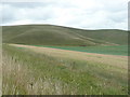
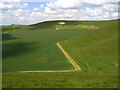
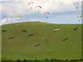
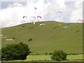
I have located the fallen stone circle described in Wikipedia I live nearby and have photos of the site that I took on Saturday.
The stone circle is fallen but is recognisable with 4+ stones in situ but fallen and others nearby.
The 'White Horse' (donkey) below Tan Hill fair would have been above the stone circle but as it is not yet a hot Summer I can not see the crop marks from where it was until 1926.
I hope there is a way of ensuring no further damage occurs to this site.
You may be viewing yesterday's version of this page. To see the most up to date information please register for a free account.
")
")
Do not use the above information on other web sites or publications without permission of the contributor.
Nearby Images from Geograph Britain and Ireland:
©2009(licence)
©2008(licence)
©2011(licence)
©2019(licence)
©2011(licence)
The above images may not be of the site on this page, they are loaded from Geograph.
Please Submit an Image of this site or go out and take one for us!
Click here to see more info for this site
Nearby sites
Key: Red: member's photo, Blue: 3rd party photo, Yellow: other image, Green: no photo - please go there and take one, Grey: site destroyed
Download sites to:
KML (Google Earth)
GPX (GPS waypoints)
CSV (Garmin/Navman)
CSV (Excel)
To unlock full downloads you need to sign up as a Contributory Member. Otherwise downloads are limited to 50 sites.
Turn off the page maps and other distractions
Nearby sites listing. In the following links * = Image available
499m SE 127° Rybury Camp* Hillfort (SU083640)
1.2km ENE 73° Tan Hill Cross Dyke* Misc. Earthwork (SU0900364643)
1.3km WNW 293° Kitchen Barrow Chambered Tomb (SU067648)
1.4km E 80° Tan Hill Tumuli* Round Barrow(s) (SU0932164561)
1.5km N 353° Horton Down Chambered Tomb (SU077658)
1.7km SSW 201° All Cannings* Modern Stone Circle etc (SU07326275)
2.0km NNW 337° Horton Down Bowl barrow Round Barrow(s) (SU07106618)
2.2km NW 313° Easton Down Bowl Barrow Round Barrow(s) (SU06316577)
2.2km ESE 103° Milk Hill Cross Dyke* Misc. Earthwork (SU10086381)
2.3km SSE 149° All Saints Church Stone* Standing Stone (Menhir) (SU0908262340)
2.3km NW 320° Easton Down Long Barrow* Long Barrow (SU064661)
2.4km NNW 343° Horton Down Enclosures Ancient Village or Settlement (SU07206657)
2.4km NE 38° Allington Down Tumulus* Round Barrow(s) (SU0936366184)
2.4km NW 324° Easton Down Bell Barrow* Round Barrow(s) (SU06506624)
2.6km ENE 65° All Cannings Down Tumulus* Round Barrow(s) (SU1023765380)
2.6km NNW 347° Hemp Knoll Enclosures 1 Misc. Earthwork (SU07326682)
2.6km NW 310° Bishop's Cannings Down 2 Round Barrow(s) (SU05926597)
2.7km NW 313° Easton Down Round Barrow Round Barrow(s) (SU05946609)
2.8km NW 319° Bishop's Cannings Down 4 Round Barrow(s) (SU06056638)
2.8km ESE 102° Alton Barnes White Horse* Hill Figure or Geoglyph (SU10676373)
2.8km E 99° Milk Hill Bowl Barrow* Round Barrow(s) (SU10716387)
2.8km NW 325° Bishop's Cannings Down 3 Round Barrow(s) (SU06276663)
2.8km WNW 301° Roughridge Hill Long Barrow* Long Barrow (SU05466578)
2.9km NW 318° Bishop's Cannings Down 1 Round Barrow(s) (SU05976641)
2.9km N 352° Hemp Knoll Enclosures 2 Misc. Earthwork (SU07496713)
View more nearby sites and additional images


 We would like to know more about this location. Please feel free to add a brief description and any relevant information in your own language.
 Wir möchten mehr über diese Stätte erfahren. Bitte zögern Sie nicht, eine kurze Beschreibung und relevante Informationen in Deutsch hinzuzufügen.
 Nous aimerions en savoir encore un peu sur les lieux. S'il vous plaît n'hesitez pas à ajouter une courte description et tous les renseignements pertinents dans votre propre langue.
 Quisieramos informarnos un poco más de las lugares. No dude en añadir una breve descripción y otros datos relevantes en su propio idioma.