<< Our Photo Pages >> Stump Cross (Mereclough) - Standing Stone (Menhir) in England in Lancashire
Submitted by vicky on Tuesday, 30 December 2003 Page Views: 10890
Neolithic and Bronze AgeSite Name: Stump Cross (Mereclough)Country: England County: Lancashire Type: Standing Stone (Menhir)
Nearest Village: Mereclough
Map Ref: SD8781130029 Landranger Map Number: 103
Latitude: 53.766463N Longitude: 2.186392W
Condition:
| 5 | Perfect |
| 4 | Almost Perfect |
| 3 | Reasonable but with some damage |
| 2 | Ruined but still recognisable as an ancient site |
| 1 | Pretty much destroyed, possibly visible as crop marks |
| 0 | No data. |
| -1 | Completely destroyed |
| 5 | Superb |
| 4 | Good |
| 3 | Ordinary |
| 2 | Not Good |
| 1 | Awful |
| 0 | No data. |
| 5 | Can be driven to, probably with disabled access |
| 4 | Short walk on a footpath |
| 3 | Requiring a bit more of a walk |
| 2 | A long walk |
| 1 | In the middle of nowhere, a nightmare to find |
| 0 | No data. |
| 5 | co-ordinates taken by GPS or official recorded co-ordinates |
| 4 | co-ordinates scaled from a detailed map |
| 3 | co-ordinates scaled from a bad map |
| 2 | co-ordinates of the nearest village |
| 1 | co-ordinates of the nearest town |
| 0 | no data |
Internal Links:
External Links:
 (PID:413)")
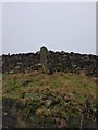
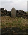
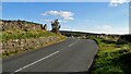
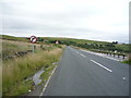
Stump Cross is a possible Bronze Age standing stone at Mereclough, near Burnley. This stone, stands by the side of the road in Mereclough at NGR: SD 87811 30029, close to the site of the Mosley Height stone circle.
This cross is Grade II listed - see Historic England List ID 1072633, which tells us the Stump Cross is on the north side of the road, and is one of the five guidestones which marked the line of the Long Causeway. HE dates it to "probably late medieval" and describe it as a "large, roughly-hewn upright set against a later dry stone wall, the relatively smooth front face crudely inscribed STUMP near the bottom".
The cross is also recorded as Pastscape Monument No. 45347, which classifies this as a medieval wayside cross, adding that a "portion of the shaft five feet high is all that remains".
The Journal of Antiquities also includes an entry for the Stump Cross, Near Mereclough, Lancashire, which includes photographs, a description, directions for finding this site and a list of reference sources for more information. The Journal adds: "The thinking is that it was originally a Bronze-Age standing stone that had stood on the moors, or it had came from a nearby stone circle? In more recent times, however, it seems to have been chopped down to its current height for it to become a marker stone or guide post, and then brought in to use as a wayside cross; there are other crosses close to the Long Causeway, which is a medieval trackway linking the towns of Burnley, Todmorden and Hebden Bridge".
You may be viewing yesterday's version of this page. To see the most up to date information please register for a free account.
 (PID:4504)")
 (PID:4505)")
Do not use the above information on other web sites or publications without permission of the contributor.
coldrum has found this location on Google Street View:
Nearby Images from Geograph Britain and Ireland:
©2020(licence)
©2008(licence)
©2022(licence)
©2013(licence)
©2016(licence)
The above images may not be of the site on this page, they are loaded from Geograph.
Please Submit an Image of this site or go out and take one for us!
Click here to see more info for this site
Nearby sites
Key: Red: member's photo, Blue: 3rd party photo, Yellow: other image, Green: no photo - please go there and take one, Grey: site destroyed
Download sites to:
KML (Google Earth)
GPX (GPS waypoints)
CSV (Garmin/Navman)
CSV (Excel)
To unlock full downloads you need to sign up as a Contributory Member. Otherwise downloads are limited to 50 sites.
Turn off the page maps and other distractions
Nearby sites listing. In the following links * = Image available
335m ENE 59° Mosley Height* Stone Circle (SD881302)
633m WNW 286° Cliviger Law (Mereclough) Cairn (SD872302)
1.5km S 187° St John the Divine (Holme-in-Cliviger) Ancient Cross (SD8763428520)
1.6km NW 311° Cliviger Laithe (Worsthorne) Cairn (SD866311)
2.4km SSW 192° Thieveley (Holme Chapel) Cairn (SD873277)
2.6km WNW 284° Foldys Cross (Towneley) Ancient Cross (SD85253065)
2.8km NNE 13° Worsthorne Moor* Stone Circle (SD8845932764)
2.9km NNE 27° Hameldon Pasture (II)* Cairn (SD8911832597)
2.9km NNE 27° Hameldon Pasture (I)* Round Barrow(s) (SD8914232622)
3.1km NNE 16° Ring Stones (Worsthorne) Stone Circle (SD8864933006)
3.1km ENE 59° Cant Clough Cairn (SD905316)
3.8km NNE 17° Twist Hill Barrow* Round Barrow(s) (SD88983370)
4.1km NNE 15° Beth Cross (Holden Clough) Ancient Cross (SD88863395)
4.1km N 7° Nogworth Cross (Briercliffe) Ancient Cross (SD8833934086)
4.3km NNE 16° Beadle Hill (Extwistle) Misc. Earthwork (SD8901834112)
4.3km NNE 17° Bonfire Hill III* Round Barrow(s) (SD891341)
4.3km NNE 19° Bonfire Hill II* Round Barrow(s) (SD892341)
4.3km NNE 31° Delf Hill* Stone Circle (SD9006433732)
4.6km NNE 20° Bonfire Hill 1* Cairn (SD894343)
4.6km SE 127° Mount Cross (Todmorden)* Ancient Cross (SD9146227284)
4.6km N 1° Calf Hey Well (Briercliffe) Holy Well or Sacred Spring (SD8794334622)
4.7km NW 310° Shorey Well (Burnley) Holy Well or Sacred Spring (SD8424433069)
4.7km NW 310° The Burnley Cross* Ancient Cross (SD8423533080)
4.7km NNE 29° Hellclough Ring Cairn* Cairn (SD9012534145)
4.7km NNE 30° Hellclough Saucer Barrow* Ring Cairn (SD9020034124)
View more nearby sites and additional images


 We would like to know more about this location. Please feel free to add a brief description and any relevant information in your own language.
 Wir möchten mehr über diese Stätte erfahren. Bitte zögern Sie nicht, eine kurze Beschreibung und relevante Informationen in Deutsch hinzuzufügen.
 Nous aimerions en savoir encore un peu sur les lieux. S'il vous plaît n'hesitez pas à ajouter une courte description et tous les renseignements pertinents dans votre propre langue.
 Quisieramos informarnos un poco más de las lugares. No dude en añadir una breve descripción y otros datos relevantes en su propio idioma.