


<< Our Photo Pages >> South Auchinclech - Standing Stones in Scotland in Aberdeenshire
Submitted by cosmic on Saturday, 09 October 2004 Page Views: 7037
Neolithic and Bronze AgeSite Name: South AuchinclechCountry: Scotland County: Aberdeenshire Type: Standing Stones
Map Ref: NJ827087
Latitude: 57.168815N Longitude: 2.287709W
Condition:
| 5 | Perfect |
| 4 | Almost Perfect |
| 3 | Reasonable but with some damage |
| 2 | Ruined but still recognisable as an ancient site |
| 1 | Pretty much destroyed, possibly visible as crop marks |
| 0 | No data. |
| -1 | Completely destroyed |
| 5 | Superb |
| 4 | Good |
| 3 | Ordinary |
| 2 | Not Good |
| 1 | Awful |
| 0 | No data. |
| 5 | Can be driven to, probably with disabled access |
| 4 | Short walk on a footpath |
| 3 | Requiring a bit more of a walk |
| 2 | A long walk |
| 1 | In the middle of nowhere, a nightmare to find |
| 0 | No data. |
| 5 | co-ordinates taken by GPS or official recorded co-ordinates |
| 4 | co-ordinates scaled from a detailed map |
| 3 | co-ordinates scaled from a bad map |
| 2 | co-ordinates of the nearest village |
| 1 | co-ordinates of the nearest town |
| 0 | no data |
Internal Links:
External Links:
")
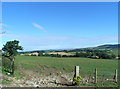
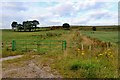
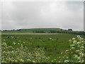
With animals in the field I could only photograph it from the estate road. It looks to be 4-5 feet high.
According to the map this single stone lies about 450m almost South of the ruiuned Auchinclech Circle - I'll have to look for it!
You may be viewing yesterday's version of this page. To see the most up to date information please register for a free account.
")
")
Do not use the above information on other web sites or publications without permission of the contributor.
Nearby Images from Geograph Britain and Ireland:
©2012(licence)
©2007(licence)
©2017(licence)
©2012(licence)
©2007(licence)
The above images may not be of the site on this page, they are loaded from Geograph.
Please Submit an Image of this site or go out and take one for us!
Click here to see more info for this site
Nearby sites
Key: Red: member's photo, Blue: 3rd party photo, Yellow: other image, Green: no photo - please go there and take one, Grey: site destroyed
Download sites to:
KML (Google Earth)
GPX (GPS waypoints)
CSV (Garmin/Navman)
CSV (Excel)
To unlock full downloads you need to sign up as a Contributory Member. Otherwise downloads are limited to 50 sites.
Turn off the page maps and other distractions
Nearby sites listing. In the following links * = Image available
1.9km W 279° Burnhead* Standing Stone (Menhir) (NJ808090)
2.0km NNW 348° Tertowie* Standing Stone (Menhir) (NJ823107)
2.8km WNW 297° Drum Stone* Natural Stone / Erratic / Other Natural Feature (NJ802100)
2.8km WNW 288° Drumstone Ring Ditch Ancient Village or Settlement (NJ800096)
2.9km SE 125° West Hatton* Chambered Cairn (NJ851070)
3.4km SW 227° Gask Stone Circle* Stone Circle (NJ80170639)
4.3km SSW 212° Woods of Cairnie Round Barrow(s) (NJ804051)
4.4km NNW 344° Newton of Lewesk* Class I Pictish Symbol Stone (NJ815129)
4.5km ENE 56° Holy Well (Chapel of Stonyewood)* Holy Well or Sacred Spring (NJ865112)
4.7km SW 233° Garlogie Wood Ancient Village or Settlement (NJ789059)
5.0km WNW 296° South Fornet* Stone Circle (NJ782109)
5.2km SE 142° Blacktop* Rock Art (NJ85900455)
5.2km NNW 349° Cairntradlin* Standing Stone (Menhir) (NJ81681385)
5.6km NE 35° Tyrebagger* Stone Circle (NJ85951322)
5.7km ENE 57° Dyce Stones* Standing Stones (NJ87481175)
5.7km N 354° Kinellar Churchyard* Stone Circle (NJ82161440)
5.7km N 354° Kinellar Pictish Symbol Stone* Class I Pictish Symbol Stone (NJ821144)
5.9km NNE 14° The Slacks* Cairn (NJ841144)
6.1km SW 223° Cullerlie* Stone Circle (NJ7851104275)
6.4km WNW 292° Breemie Stones* Modern Stone Circle etc (NJ768111)
6.4km NNW 337° Ferneybrae* Standing Stone (Menhir) (NJ80211459)
6.5km N 6° Gouk Stone* Standing Stone (Menhir) (NJ8344815171)
6.9km SSE 156° Binghill* Stone Circle (NJ85520237)
7.1km NNW 333° Midmill Chambered Cairn (NJ795151)
7.4km NNW 334° Tuack* Stone Circle (NJ795154)
View more nearby sites and additional images


 We would like to know more about this location. Please feel free to add a brief description and any relevant information in your own language.
 Wir möchten mehr über diese Stätte erfahren. Bitte zögern Sie nicht, eine kurze Beschreibung und relevante Informationen in Deutsch hinzuzufügen.
 Nous aimerions en savoir encore un peu sur les lieux. S'il vous plaît n'hesitez pas à ajouter une courte description et tous les renseignements pertinents dans votre propre langue.
 Quisieramos informarnos un poco más de las lugares. No dude en añadir una breve descripción y otros datos relevantes en su propio idioma.