


<< Our Photo Pages >> Colerne Cross. - Ancient Cross in England in Wiltshire
Submitted by Thorgrim on Saturday, 09 October 2004 Page Views: 9640
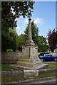
Early Medieval (Dark Age)Site Name: Colerne Cross.Country: England County: Wiltshire Type: Ancient Cross
Nearest Town: Chippenham Nearest Village: Colerne
Map Ref: ST820711
Latitude: 51.438606N Longitude: 2.260353W
Condition:
| 5 | Perfect |
| 4 | Almost Perfect |
| 3 | Reasonable but with some damage |
| 2 | Ruined but still recognisable as an ancient site |
| 1 | Pretty much destroyed, possibly visible as crop marks |
| 0 | No data. |
| -1 | Completely destroyed |
| 5 | Superb |
| 4 | Good |
| 3 | Ordinary |
| 2 | Not Good |
| 1 | Awful |
| 0 | No data. |
| 5 | Can be driven to, probably with disabled access |
| 4 | Short walk on a footpath |
| 3 | Requiring a bit more of a walk |
| 2 | A long walk |
| 1 | In the middle of nowhere, a nightmare to find |
| 0 | No data. |
| 5 | co-ordinates taken by GPS or official recorded co-ordinates |
| 4 | co-ordinates scaled from a detailed map |
| 3 | co-ordinates scaled from a bad map |
| 2 | co-ordinates of the nearest village |
| 1 | co-ordinates of the nearest town |
| 0 | no data |
Internal Links:
External Links:
I have visited· I would like to visit
coin has visited here
")
Jelling style Danish Viking sculpture is an incredible find in rural Wiltshire. Inter woven dragons biting their tails was a favourite theme.
You may be viewing yesterday's version of this page. To see the most up to date information please register for a free account.
")
")
")
Do not use the above information on other web sites or publications without permission of the contributor.
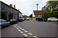
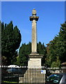
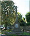
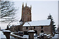
Nearby Images from Geograph Britain and Ireland:
©2016(licence)
©2008(licence)
©2008(licence)
©2009(licence)
©2016(licence)
The above images may not be of the site on this page, they are loaded from Geograph.
Please Submit an Image of this site or go out and take one for us!
Click here to see more info for this site
Nearby sites
Key: Red: member's photo, Blue: 3rd party photo, Yellow: other image, Green: no photo - please go there and take one, Grey: site destroyed
Download sites to:
KML (Google Earth)
GPX (GPS waypoints)
CSV (Garmin/Navman)
CSV (Excel)
To unlock full downloads you need to sign up as a Contributory Member. Otherwise downloads are limited to 50 sites.
Turn off the page maps and other distractions
Nearby sites listing. In the following links * = Image available
2.4km S 173° Box Rock Circus* Modern Stone Circle etc (ST823687)
2.6km WSW 245° Three Shires Stones* Modern Stone Circle etc (ST7961070021)
2.6km NE 35° The Danes Tump* Round Barrow(s) (ST83547325)
2.7km S 169° Becket's Well (Box) Holy Well or Sacred Spring (ST825684)
2.9km N 356° Bury Camp (Wiltshire)* Hillfort (ST818740)
3.2km SSE 152° Hazelbury Manor Menhirs* Modern Stone Circle etc (ST83476830)
3.5km NNE 21° Colerne Cross Dyke* Misc. Earthwork (ST83267436)
5.6km SSW 197° Monk's Conduit (Monkton Farleigh)* Holy Well or Sacred Spring (ST8036265692)
6.0km WSW 238° Solsbury Hill* Hillfort (ST76876797)
6.2km ENE 75° Holy Well (Biddestone)* Holy Well or Sacred Spring (ST8802772733)
6.8km ENE 58° Lanhill* Long Barrow (ST87737471)
7.5km N 8° Lugbury* Chambered Tomb (ST83097856)
7.6km SW 217° Bathampton Camp* Hillfort (ST77456502)
7.6km SW 219° Bathampton* Standing Stones (ST772652)
7.7km NW 319° West Littleton Down* Round Barrow(s) (ST769769)
7.8km SW 229° Kensington Meadows Holed Megalith Holed Stone
7.9km NNW 330° Fox Covert NW* Chambered Tomb (ST78087791)
8.0km NNW 330° Tormarton 1* Long Barrow (ST77957805)
8.1km WSW 242° St Mary's Well (Charlcombe)* Holy Well or Sacred Spring (ST748673)
8.2km SW 221° Bathampton Round Barrow 2* Round Barrow(s) (ST76616489)
8.4km SSW 196° Jug's Grave* Round Barrow(s) (ST79696305)
8.4km NNE 15° Castle Coombe Cursus (ST842792)
8.4km NNE 12° Castle Coombe Cursus (ST838793)
8.7km SSW 197° Conkwell stone circle* Stone Circle (ST79456280)
8.7km W 266° Cold Ashton Round Barrows* Round Barrow(s) (ST73257045)
View more nearby sites and additional images


 We would like to know more about this location. Please feel free to add a brief description and any relevant information in your own language.
 Wir möchten mehr über diese Stätte erfahren. Bitte zögern Sie nicht, eine kurze Beschreibung und relevante Informationen in Deutsch hinzuzufügen.
 Nous aimerions en savoir encore un peu sur les lieux. S'il vous plaît n'hesitez pas à ajouter une courte description et tous les renseignements pertinents dans votre propre langue.
 Quisieramos informarnos un poco más de las lugares. No dude en añadir una breve descripción y otros datos relevantes en su propio idioma.