<< Our Photo Pages >> Symonds Hall Farm - Long Barrow in England in Gloucestershire
Submitted by TheCaptain on Thursday, 18 November 2004 Page Views: 10653
Neolithic and Bronze AgeSite Name: Symonds Hall Farm Alternative Name: Wotton under Edge IICountry: England County: Gloucestershire Type: Long Barrow
Nearest Town: Wotton-under-Edge Nearest Village: Kingscote
Map Ref: ST79719599 Landranger Map Number: 162
Latitude: 51.662321N Longitude: 2.294742W
Condition:
| 5 | Perfect |
| 4 | Almost Perfect |
| 3 | Reasonable but with some damage |
| 2 | Ruined but still recognisable as an ancient site |
| 1 | Pretty much destroyed, possibly visible as crop marks |
| 0 | No data. |
| -1 | Completely destroyed |
| 5 | Superb |
| 4 | Good |
| 3 | Ordinary |
| 2 | Not Good |
| 1 | Awful |
| 0 | No data. |
| 5 | Can be driven to, probably with disabled access |
| 4 | Short walk on a footpath |
| 3 | Requiring a bit more of a walk |
| 2 | A long walk |
| 1 | In the middle of nowhere, a nightmare to find |
| 0 | No data. |
| 5 | co-ordinates taken by GPS or official recorded co-ordinates |
| 4 | co-ordinates scaled from a detailed map |
| 3 | co-ordinates scaled from a bad map |
| 2 | co-ordinates of the nearest village |
| 1 | co-ordinates of the nearest town |
| 0 | no data |
Internal Links:
External Links:
I have visited· I would like to visit
4clydesdale7 visited on 22nd May 2011 - their rating: Amb: 3 Access: 2 Went all round it trying to get nearer - followed by anxious local farmer who warmed to my task if only begrudgingly - maybe he was having an off day
TheCaptain have visited here
")
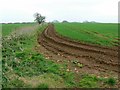
The fields were empty at the time I was there, so I nipped in for a look. Obviously once a very large barrow, it is now in two parts, a southwestern round bit, and a northeastern elongated bit, all very disturbed and with large dips and excavations in the top.
The mound is obviously constructed from stones, and there are remains of some fairly large stone slabs still to be seen in places. It obviously was once fenced off, as there are remains of fence posts surrounding the remains.
This site now consists of two mounds, one to the north-east and one to the south-west with ploughed land in between. However, a 17th Century reference describes a single 'hill or tumpe'.
References
Megalithic Enquiries in the West of Britain, T.G.E.Powell et Al (Liverpool 1969)
You may be viewing yesterday's version of this page. To see the most up to date information please register for a free account.
")
")
")
Do not use the above information on other web sites or publications without permission of the contributor.
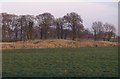
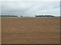
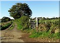
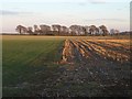
Nearby Images from Geograph Britain and Ireland:
©2010(licence)
©2016(licence)
©2012(licence)
©2010(licence)
©2008(licence)
The above images may not be of the site on this page, they are loaded from Geograph.
Please Submit an Image of this site or go out and take one for us!
Click here to see more info for this site
Nearby sites
Key: Red: member's photo, Blue: 3rd party photo, Yellow: other image, Green: no photo - please go there and take one, Grey: site destroyed
Download sites to:
KML (Google Earth)
GPX (GPS waypoints)
CSV (Garmin/Navman)
CSV (Excel)
To unlock full downloads you need to sign up as a Contributory Member. Otherwise downloads are limited to 50 sites.
Turn off the page maps and other distractions
Nearby sites listing. In the following links * = Image available
865m WNW 291° Wotton Under Edge Cursus Cursus (ST789963)
2.0km SE 132° Kingscote Standing Stones* Standing Stones (ST81189467)
2.1km WNW 296° Rowden Wood* Chambered Tomb (ST77819692)
2.5km WNW 291° Folly Wood* Chambered Tomb (ST77339689)
2.8km SSE 147° Brock Hill Round Barrow(s) (ST81219363)
2.8km NE 55° Woodleaze Farm* Long Barrow (ST820976)
3.2km NNW 336° Uley Bury* Hillfort (ST78459891)
3.2km ENE 60° Woodleaze Bowl Barrow* Round Barrow(s) (ST82489757)
3.5km SW 218° Blackquarries Hill* Chambered Tomb (ST77529323)
3.9km SSE 151° St. Mary's Well (Boxwell)* Holy Well or Sacred Spring (ST816926)
4.1km N 349° Hetty Pegler's Tump* Passage Grave (SO78960003)
4.1km NNW 328° Cam Long Down Hillfort* Hillfort (ST7753399507)
4.2km NE 34° Lutheredge Earthworks* Misc. Earthwork (ST82089943)
4.2km SSE 148° Boxwell Lodge* Chambered Tomb (ST819924)
4.5km WNW 297° The Broadwell* Holy Well or Sacred Spring (ST75749807)
4.9km ESE 121° Beverston Barrow 1* Round Barrow(s) (ST83949344)
5.1km WSW 257° Brackenbury Ditches* Promontory Fort / Cliff Castle (ST74709485)
5.2km SSE 155° Leighterton Long Barrow* Long Barrow (ST81929131)
5.3km N 356° Nympsfield* Long Barrow (SO79400132)
5.5km N 356° Soldier's Grave* Round Barrow(s) (SO79350150)
5.6km N 1° Buckholt Wood* Chambered Tomb (SO79860157)
5.9km NW 304° Dursley Merestone* Marker Stone (ST748993)
6.1km NNE 13° Woodchester Beaker Barrow* Round Barrow(s) (SO81100198)
6.2km SE 129° Bowldownwood Round Barrows* Round Barrow(s) (ST84569205)
6.3km NNE 24° Bown Hill Long Barrow* Long Barrow (SO82290179)
View more nearby sites and additional images


 We would like to know more about this location. Please feel free to add a brief description and any relevant information in your own language.
 Wir möchten mehr über diese Stätte erfahren. Bitte zögern Sie nicht, eine kurze Beschreibung und relevante Informationen in Deutsch hinzuzufügen.
 Nous aimerions en savoir encore un peu sur les lieux. S'il vous plaît n'hesitez pas à ajouter une courte description et tous les renseignements pertinents dans votre propre langue.
 Quisieramos informarnos un poco más de las lugares. No dude en añadir una breve descripción y otros datos relevantes en su propio idioma.