<< Our Photo Pages >> Nympsfield - Long Barrow in England in Gloucestershire
Submitted by Andy B on Monday, 30 November 2015 Page Views: 16482
Neolithic and Bronze AgeSite Name: Nympsfield Alternative Name: Frocester ICountry: England County: Gloucestershire Type: Long Barrow
Nearest Town: Stroud Nearest Village: Nympsfield
Map Ref: SO79400132 Landranger Map Number: 162
Latitude: 51.710232N Longitude: 2.299541W
Condition:
| 5 | Perfect |
| 4 | Almost Perfect |
| 3 | Reasonable but with some damage |
| 2 | Ruined but still recognisable as an ancient site |
| 1 | Pretty much destroyed, possibly visible as crop marks |
| 0 | No data. |
| -1 | Completely destroyed |
| 5 | Superb |
| 4 | Good |
| 3 | Ordinary |
| 2 | Not Good |
| 1 | Awful |
| 0 | No data. |
| 5 | Can be driven to, probably with disabled access |
| 4 | Short walk on a footpath |
| 3 | Requiring a bit more of a walk |
| 2 | A long walk |
| 1 | In the middle of nowhere, a nightmare to find |
| 0 | No data. |
| 5 | co-ordinates taken by GPS or official recorded co-ordinates |
| 4 | co-ordinates scaled from a detailed map |
| 3 | co-ordinates scaled from a bad map |
| 2 | co-ordinates of the nearest village |
| 1 | co-ordinates of the nearest town |
| 0 | no data |
Internal Links:
External Links:
I have visited· I would like to visit
SumDoood would like to visit
NDM visited on 1st Feb 2023 - their rating: Access: 5
TheCaptain visited on 29th Sep 2021 - their rating: Cond: 3 Amb: 3 Access: 5 Fabulous loop walk from Coaley Peak picnic area, starting with a look at Nympsfield long barrow, then down through and past the lakes of Woodchester Park, back up through the vineyards to Selsey Common, before turning back along the Cotswold Way through the lovely woodland on the edge of the hills.
drolaf visited on 20th Jun 2021 - their rating: Cond: 3 Amb: 4 Access: 4 just one of several long barrows along the ridge, it lies in the steep escarpment edge but faces east.
SSpedS visited on 26th Apr 2020 - their rating: Cond: 4 Amb: 4 Access: 4
UnnaturalDisaster visited on 21st May 2018 - their rating: Cond: 2 Amb: 3 Access: 5
lichen visited on 29th Jul 2013 - their rating: Cond: 3 Amb: 4 Access: 5
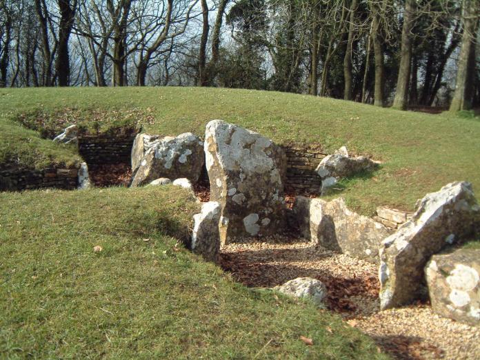
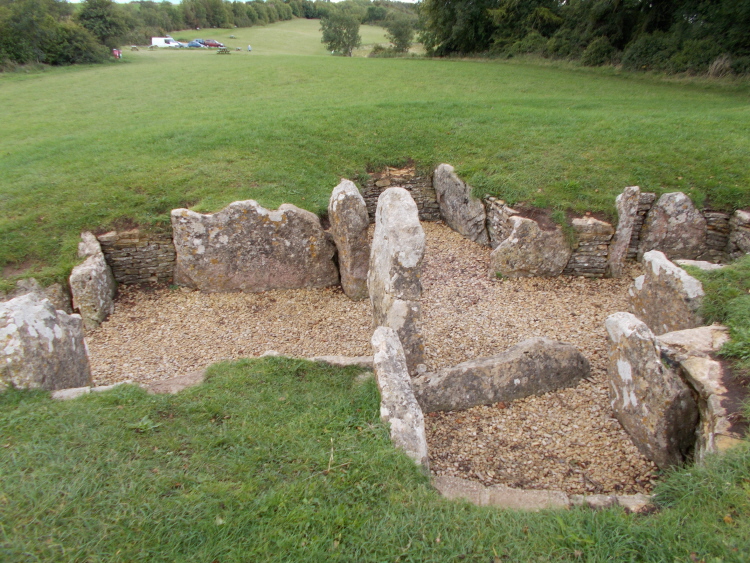
custer visited on 2nd Apr 2013 - their rating: Cond: 2 Amb: 4 Access: 5 Lovely site roof removed can see structure and layout. Nice area for stopping and admiring the view this mound looked out across.
4clydesdale7 visited on 22nd May 2011 - their rating: Cond: 3 Amb: 3 Access: 5 Manicured to the point almost of being contrived - obviously a well trodden picnic spot with excellent views over the Severn Vale
TheWhiteRider visited on 21st Jun 2010 - their rating: Cond: 3 Amb: 4 Access: 5
meandering_morleys visited on 1st May 2010 - their rating: Cond: 3 Amb: 4 Access: 5
woodini254 visited on 28th Dec 2009 - their rating: Cond: 2 Amb: 4 Access: 5 This site is situated in a car park maintained by Gloucestershire County Council. Although damaged it is still worth a visit.
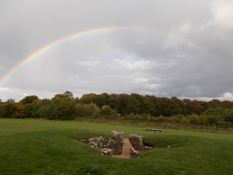
TheCaptain visited on 14th Mar 2009 - their rating: Cond: 3 Amb: 3 Access: 5 This Chambered long barrow with a pair of side chambers and an end chamber, is located in Coaley Peak picnic area, on the edge of the Cotswold Hills in Gloucestershire. Once covered by a mound 27m long by 18m wide and with a horned forecourt, it contained between 20 and 30 burials. These days it is an easy and pleasant place to visit, with plenty of parking, picnic areas etc nearby, and some splendid views from the edge of the Cotswold Hills over the Severn Valley below, and over to the Forest of Dean and the Welsh Hills.
graemefield visited on 1st May 1990 - their rating: Cond: 3 Amb: 4 Access: 4
jeniferj visited - their rating: Cond: 2 Amb: 3 Access: 5
TheWhiteRider visited - their rating: Cond: 3 Amb: 4 Access: 5
TheWhiteRider visited - their rating: Cond: 3 Amb: 4 Access: 5
bishop_pam visited - their rating: Cond: 5 Amb: 5 Access: 5
Geojazz Humbucker neolithique02 DrewParsons AngieLake hamish NickyD coin mdensham have visited here
Average ratings for this site from all visit loggers: Condition: 2.94 Ambience: 3.75 Access: 4.82

These days it is an easy and pleasant place to visit, with plenty of parking, picnic areas etc nearby, and some splendid views from the edge of the Cotswold Hills over the Severn Valley below, and over to the Forest of Dean and the Welsh Hills.
Well worth a visit.
Site page originally by Vicky Morgan.
You may be viewing yesterday's version of this page. To see the most up to date information please register for a free account.


These are just the first 25 photos of Nympsfield. If you log in with a free user account you will be able to see our entire collection.
Do not use the above information on other web sites or publications without permission of the contributor.
Click here to see more info for this site
Nearby sites
Key: Red: member's photo, Blue: 3rd party photo, Yellow: other image, Green: no photo - please go there and take one, Grey: site destroyed
Download sites to:
KML (Google Earth)
GPX (GPS waypoints)
CSV (Garmin/Navman)
CSV (Excel)
To unlock full downloads you need to sign up as a Contributory Member. Otherwise downloads are limited to 50 sites.
Turn off the page maps and other distractions
Nearby sites listing. In the following links * = Image available
187m NNW 344° Soldier's Grave* Round Barrow(s) (SO79350150)
522m ENE 61° Buckholt Wood* Chambered Tomb (SO79860157)
1.4km SSW 199° Hetty Pegler's Tump* Passage Grave (SO78960003)
1.8km ENE 68° Woodchester Beaker Barrow* Round Barrow(s) (SO81100198)
2.5km ENE 72° Kings Stanley Dyke* Misc. Earthwork (SO818021)
2.6km SSW 201° Uley Bury* Hillfort (ST78459891)
2.6km SW 226° Cam Long Down Hillfort* Hillfort (ST7753399507)
2.9km E 79° Bown Hill Bowl Barrow* Round Barrow(s) (SO82240184)
2.9km E 81° Bown Hill Long Barrow* Long Barrow (SO82290179)
3.3km SE 125° Lutheredge Earthworks* Misc. Earthwork (ST82089943)
3.7km ENE 61° The Toots (King's Stanley)* Long Barrow (SO82700310)
4.5km SE 145° Woodleaze Farm* Long Barrow (ST820976)
4.7km SSW 200° Rowden Wood* Chambered Tomb (ST77819692)
4.8km SE 140° Woodleaze Bowl Barrow* Round Barrow(s) (ST82489757)
4.9km ENE 68° Woodchester Roman Villa* Ancient Village or Settlement (SO8394503128)
4.9km SSW 205° Folly Wood* Chambered Tomb (ST77339689)
4.9km SW 228° The Broadwell* Holy Well or Sacred Spring (ST75749807)
5.0km WSW 246° Dursley Merestone* Marker Stone (ST748993)
5.0km S 185° Wotton Under Edge Cursus Cursus (ST789963)
5.3km S 176° Symonds Hall Farm* Long Barrow (ST79719599)
5.7km ENE 70° Bowl Hill Circle* Natural Stone / Erratic / Other Natural Feature (SO8476403248)
5.7km E 91° Amberley Cross Bank* Misc. Earthwork (SO85130124)
5.8km E 89° Amberley Camp* Misc. Earthwork (SO852014)
6.0km ENE 71° Rodborough Camp* Ancient Village or Settlement (SO85050324)
6.0km E 86° Whitefield's Tump* Long Barrow (SO85400170)
View more nearby sites and additional images


 We would like to know more about this location. Please feel free to add a brief description and any relevant information in your own language.
 Wir möchten mehr über diese Stätte erfahren. Bitte zögern Sie nicht, eine kurze Beschreibung und relevante Informationen in Deutsch hinzuzufügen.
 Nous aimerions en savoir encore un peu sur les lieux. S'il vous plaît n'hesitez pas à ajouter une courte description et tous les renseignements pertinents dans votre propre langue.
 Quisieramos informarnos un poco más de las lugares. No dude en añadir una breve descripción y otros datos relevantes en su propio idioma.