<< Our Photo Pages >> Bodbury Ring - Hillfort in England in Shropshire
Submitted by TimPrevett on Thursday, 03 June 2004 Page Views: 14541
Iron Age and Later PrehistorySite Name: Bodbury RingCountry: England County: Shropshire Type: Hillfort
Nearest Town: Church Stretton
Map Ref: SO445947 Landranger Map Number: 137
Latitude: 52.547306N Longitude: 2.819875W
Condition:
| 5 | Perfect |
| 4 | Almost Perfect |
| 3 | Reasonable but with some damage |
| 2 | Ruined but still recognisable as an ancient site |
| 1 | Pretty much destroyed, possibly visible as crop marks |
| 0 | No data. |
| -1 | Completely destroyed |
| 5 | Superb |
| 4 | Good |
| 3 | Ordinary |
| 2 | Not Good |
| 1 | Awful |
| 0 | No data. |
| 5 | Can be driven to, probably with disabled access |
| 4 | Short walk on a footpath |
| 3 | Requiring a bit more of a walk |
| 2 | A long walk |
| 1 | In the middle of nowhere, a nightmare to find |
| 0 | No data. |
| 5 | co-ordinates taken by GPS or official recorded co-ordinates |
| 4 | co-ordinates scaled from a detailed map |
| 3 | co-ordinates scaled from a bad map |
| 2 | co-ordinates of the nearest village |
| 1 | co-ordinates of the nearest town |
| 0 | no data |
Internal Links:
External Links:
I have visited· I would like to visit
SolarMegalith would like to visit
TimPrevett Serenstar have visited here
")
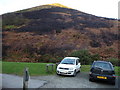
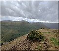
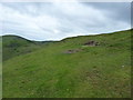
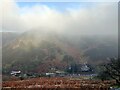
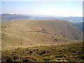
A small univallate hillfort, survivng from the Iron Age as a ring with a commanding view across the area. It possibly incorporates an earlier cross dyke. The Ring immediately overlooks Carding Mill Valley, cared for by the National Trust, on the eastern edge of The Long Mynd, also under the NT's care. Caer Caradoc (Church Stretton) and The Lawley are to its east, and The Wrekin is obvious on the skyline to the north-east. All these are also the sites of hillforts and settlements.In the family room of the restaurant in Carding Mill Valley, there is an artist's impression of how Bodbury Ring, with Caer Caradoc behind it would have looked with huts, and pallisades upon their earthworks.
You may be viewing yesterday's version of this page. To see the most up to date information please register for a free account.
")
")
Do not use the above information on other web sites or publications without permission of the contributor.
Nearby Images from Geograph Britain and Ireland:
©2010(licence)
©2022(licence)
©2012(licence)
©2023(licence)
©2010(licence)
The above images may not be of the site on this page, they are loaded from Geograph.
Please Submit an Image of this site or go out and take one for us!
Click here to see more info for this site
Nearby sites
Key: Red: member's photo, Blue: 3rd party photo, Yellow: other image, Green: no photo - please go there and take one, Grey: site destroyed
Download sites to:
KML (Google Earth)
GPX (GPS waypoints)
CSV (Garmin/Navman)
CSV (Excel)
To unlock full downloads you need to sign up as a Contributory Member. Otherwise downloads are limited to 50 sites.
Turn off the page maps and other distractions
Nearby sites listing. In the following links * = Image available
709m SW 230° The Devil's Mouth Cross Dyke* Misc. Earthwork (SO43959425)
1.3km SE 144° Stretton Sheela* Early Christian Sculptured Stone (SO45239368)
1.6km SSW 198° Ashlet Hill Bowl Barrow Round Barrow(s) (SO440932)
1.9km W 263° Long Mynd A* Round Barrow(s) (SO426945)
2.0km NE 52° Castle Hill (Shropshire)* Hillfort (SO461959)
2.0km N 354° High Park Cross Dyke* Ancient Village or Settlement (SO443967)
2.2km W 267° Boiling Well (Long Mynd)* Round Barrow(s) (SO423946)
2.3km WNW 289° Long Mynd C* Round Barrow(s) (SO423955)
2.4km NW 321° Robin Hood's Butts (Shropshire)* Round Barrow(s) (SO43029655)
2.5km WNW 286° Shooting Box Disc Barrow* Round Barrow(s) (SO421954)
2.7km NW 321° Henley Knap Bowl Barrow* Round Barrow(s) (SO42799685)
2.8km SW 223° Barrister's Plain Cross Dyke* Ancient Village or Settlement (SO426927)
2.8km SW 215° Cross Dyke Bowl Barrow North* Round Barrow(s) (SO42899244)
2.8km SW 215° Cross Dyke Bowl Barrow South* Round Barrow(s) (SO42869241)
2.9km NW 313° Wildmoor Bowl Barrow* Round Barrow(s) (SO42409672)
3.2km ENE 79° Caer Caradoc (Church Stretton)* Hillfort (SO477953)
3.3km WSW 244° Long Mynd B* Round Barrow(s) (SO41539330)
3.4km ESE 103° Hope Bowdler Hill* Cairn (SO47779389)
3.5km WSW 256° Pole Cottage* Round Barrow(s) (SO411939)
3.6km E 80° Caer Caradoc Round Barrow* Round Barrow(s) (SO48059529)
4.6km NW 304° Ratlinghope Hill Camp* Hillfort (SO407973)
4.8km NW 316° Ratlinghope Hill Bowl Barrow* Round Barrow(s) (SO41179817)
4.9km WSW 252° Robury Ring* Misc. Earthwork (SO39799321)
5.1km NW 307° Castle Ring (Stitt Hill)* Hillfort (SO405978)
5.6km ENE 60° The Lawley (Summit)* Hillfort (SO49459745)
View more nearby sites and additional images


 We would like to know more about this location. Please feel free to add a brief description and any relevant information in your own language.
 Wir möchten mehr über diese Stätte erfahren. Bitte zögern Sie nicht, eine kurze Beschreibung und relevante Informationen in Deutsch hinzuzufügen.
 Nous aimerions en savoir encore un peu sur les lieux. S'il vous plaît n'hesitez pas à ajouter une courte description et tous les renseignements pertinents dans votre propre langue.
 Quisieramos informarnos un poco más de las lugares. No dude en añadir una breve descripción y otros datos relevantes en su propio idioma.