<< Our Photo Pages >> The Golden Well (Dorstone) - Holy Well or Sacred Spring in England in Herefordshire
Submitted by Sunny100 on Saturday, 21 July 2012 Page Views: 3746
Springs and Holy WellsSite Name: The Golden Well (Dorstone)Country: England
NOTE: This site is 0.3 km away from the location you searched for.
County: Herefordshire Type: Holy Well or Sacred Spring
Nearest Town: Hay-on-Wye Nearest Village: Dorstone
Map Ref: SO30804228
Latitude: 52.074541N Longitude: 3.011078W
Condition:
| 5 | Perfect |
| 4 | Almost Perfect |
| 3 | Reasonable but with some damage |
| 2 | Ruined but still recognisable as an ancient site |
| 1 | Pretty much destroyed, possibly visible as crop marks |
| 0 | No data. |
| -1 | Completely destroyed |
| 5 | Superb |
| 4 | Good |
| 3 | Ordinary |
| 2 | Not Good |
| 1 | Awful |
| 0 | No data. |
| 5 | Can be driven to, probably with disabled access |
| 4 | Short walk on a footpath |
| 3 | Requiring a bit more of a walk |
| 2 | A long walk |
| 1 | In the middle of nowhere, a nightmare to find |
| 0 | No data. |
| 5 | co-ordinates taken by GPS or official recorded co-ordinates |
| 4 | co-ordinates scaled from a detailed map |
| 3 | co-ordinates scaled from a bad map |
| 2 | co-ordinates of the nearest village |
| 1 | co-ordinates of the nearest town |
| 0 | no data |
Internal Links:
External Links:
I have visited· I would like to visit
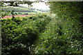
AJHL visited on 31st Dec 2022 - their rating: Cond: 1 Amb: 4 Access: 4 The wood has been cut down resulting in new undergrowth over marshy ground. Quite difficult to find but it’s still there
4clydesdale7 visited on 31st May 2013 - their rating: Cond: 2 Amb: 3 Access: 3 Recent drainage work seems to have very badly affected the Well - do plenty of research on maps before you go
Average ratings for this site from all visit loggers: Condition: 1.5 Ambience: 3.5 Access: 3.5
 (PID:254532)")
But according to local legend, a sacred trout used to swim in the pool and local people used to come here to see this spectacle and no doubt make wishes or hope for some miracle which would help them with whatever ailments they suffered from. This sacred trout could be the one displayed in St Peter's church at nearby Peterchurch.
You may be viewing yesterday's version of this page. To see the most up to date information please register for a free account.
Do not use the above information on other web sites or publications without permission of the contributor.
Nearby Images from Geograph Britain and Ireland:
©2012(licence)
©2012(licence)
©2012(licence)
©2012(licence)
©2006(licence)
The above images may not be of the site on this page, they are loaded from Geograph.
Please Submit an Image of this site or go out and take one for us!
Click here to see more info for this site
Nearby sites
Key: Red: member's photo, Blue: 3rd party photo, Yellow: other image, Green: no photo - please go there and take one, Grey: site destroyed
Download sites to:
KML (Google Earth)
GPX (GPS waypoints)
CSV (Garmin/Navman)
CSV (Excel)
To unlock full downloads you need to sign up as a Contributory Member. Otherwise downloads are limited to 50 sites.
Turn off the page maps and other distractions
Nearby sites listing. In the following links * = Image available
1.4km NE 51° Arthur's Stone* Chambered Tomb (SO3188843124)
1.8km E 89° Dorstone Hill* Ancient Village or Settlement (SO32604230)
2.5km ENE 71° Pentre House Standing Stone* Standing Stone (Menhir) (SO33154307)
2.5km ESE 103° Great Llanavon Farm* Long Barrow (SO3322441689)
2.5km NE 38° Chapel field Hillfort (SO32404425)
2.9km NE 34° The Knapp (Bredwardine)* Ancient Village or Settlement (SO32454467)
3.5km NE 49° Bredwardine Church* Carving (SO33484450)
5.0km S 184° Wern Derys* Standing Stone (Menhir) (SO30363726)
5.5km ESE 102° Blakemere Church Stone* Marker Stone (SO362411)
5.7km SE 127° Peterchurch St Peter's Well* Holy Well or Sacred Spring (SO35333880)
6.5km E 98° Holy Well (Blakemere)* Holy Well or Sacred Spring (SO37254128)
6.6km NW 322° St Peter's Well, Whitney on Wye* Holy Well or Sacred Spring (SO268475)
6.9km SE 131° Poston Camp Hillfort (SO3598937647)
7.6km WSW 240° Twyn-Y-Beddau* Round Barrow(s) (SO2414838610)
8.2km SW 236° Maes-Coch Chambered Cairn (SO239378)
8.3km W 269° The Walk Well* Holy Well or Sacred Spring (SO225422)
8.3km W 276° The Monk's Well* Holy Well or Sacred Spring (SO225432)
8.4km SW 233° Pen Y Beacon* Stone Circle (SO23933735)
8.6km WSW 253° Pen-y-Wyrlod* Chambered Tomb (SO22483987)
9.5km WNW 290° Crossfoot Farm Standing Stone* Standing Stone (Menhir) (SO21874573)
9.6km W 274° Clyro Court* Chambered Tomb (SO21234315)
9.7km SE 125° Timberline Camp Hillfort (SO387367)
10.5km SSW 192° St. Thomas' Well* Holy Well or Sacred Spring (SO28433201)
10.9km S 182° Llanveyno Crosses* Ancient Cross (SO3031131361)
11.5km W 266° St Maelog's Cross* Ancient Cross (SO1923941704)
View more nearby sites and additional images


 We would like to know more about this location. Please feel free to add a brief description and any relevant information in your own language.
 Wir möchten mehr über diese Stätte erfahren. Bitte zögern Sie nicht, eine kurze Beschreibung und relevante Informationen in Deutsch hinzuzufügen.
 Nous aimerions en savoir encore un peu sur les lieux. S'il vous plaît n'hesitez pas à ajouter une courte description et tous les renseignements pertinents dans votre propre langue.
 Quisieramos informarnos un poco más de las lugares. No dude en añadir una breve descripción y otros datos relevantes en su propio idioma.