


<< Our Photo Pages >> St Maelog's Cross - Ancient Cross in Wales in Powys
Submitted by Sunny100 on Sunday, 09 May 2010 Page Views: 6880
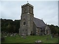
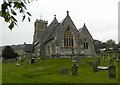
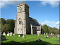
Early Medieval (Dark Age)Site Name: St Maelog's Cross Alternative Name: The Llowes Cross, Malwalbee's Stone, St Meilig's Church, St Meulog's CrossCountry: Wales County: Powys Type: Ancient Cross
Nearest Town: Hay On Wye Nearest Village: Llowes
Map Ref: SO1923941704
Latitude: 52.067796N Longitude: 3.179587W
Condition:
| 5 | Perfect |
| 4 | Almost Perfect |
| 3 | Reasonable but with some damage |
| 2 | Ruined but still recognisable as an ancient site |
| 1 | Pretty much destroyed, possibly visible as crop marks |
| 0 | No data. |
| -1 | Completely destroyed |
| 5 | Superb |
| 4 | Good |
| 3 | Ordinary |
| 2 | Not Good |
| 1 | Awful |
| 0 | No data. |
| 5 | Can be driven to, probably with disabled access |
| 4 | Short walk on a footpath |
| 3 | Requiring a bit more of a walk |
| 2 | A long walk |
| 1 | In the middle of nowhere, a nightmare to find |
| 0 | No data. |
| 5 | co-ordinates taken by GPS or official recorded co-ordinates |
| 4 | co-ordinates scaled from a detailed map |
| 3 | co-ordinates scaled from a bad map |
| 2 | co-ordinates of the nearest village |
| 1 | co-ordinates of the nearest town |
| 0 | no data |
Internal Links:
External Links:
I have visited· I would like to visit
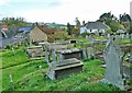
Anne T saw from a distance on 12th Jul 2021 St Maelog's Cross: Despite being told the church was open, and going armed with masks and hand sanitiser, the door was very firmly locked. We could see the back of the cross through the windows at the north western corner of the church, but it was impossible to photograph through the tiny, dirty panes. So disappointed. I did spot a sundial in the churchyard, built into a memorial stone, so had to be content with photographing that.
Andy B have visited here
")
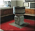
The Celtic cross on the front side is well defined and quite spectacular. However, the carved cross on the opposite side was added in the 11th century and is not that special. The cross-slab is said to weigh 3 tonnes.
St Maelog or Meilig was a 6th century monk and a native of Clydeside in Scotland. He was a soldier but decided to abandon that way of life for a Christian one. Maelog came to Wales for training under St Cadoc at the monastic college of Llancarvan. When he arrived at Llowes a St Llywes (after whom the village is named) was already in occupancy. He departed and left St Maelog to found a smally monastery here. It seems quite likely that the saint used this pre-historic stone in his Christianisation of the area, having a Christian cross carved onto it. St Maelog was the brother of St Gildas the Historian.
A local legend says that a 12th century giantess called Malwalbee (Maud de Braose) of Hay Castle got the stone, or pebble to her, caught in her apron and because it started to annoy her she threw it across the River Wye to where Llowes church now stands.
This cross slab is recorded as Coflein NPRN 96531, Cross Slab, St Meilig's Church, Llowes, which includes a description and local traditions. The Journal of Antiquities also includes an entry for St Maelog’s Cross, Llowes, Powys, which includes a photograph and a drawing of the cross slab, a description, and background information about both the church an St Maelog (aka Meulog or Meilig), together with local folklore and a list of reference sources for more information.
You may be viewing yesterday's version of this page. To see the most up to date information please register for a free account.
")
")
Do not use the above information on other web sites or publications without permission of the contributor.
Nearby Images from Geograph Britain and Ireland:
©2009(licence)
©2013(licence)
©2020(licence)
©2020(licence)
©2012(licence)
The above images may not be of the site on this page, they are loaded from Geograph.
Please Submit an Image of this site or go out and take one for us!
Click here to see more info for this site
Nearby sites
Key: Red: member's photo, Blue: 3rd party photo, Yellow: other image, Green: no photo - please go there and take one, Grey: site destroyed
Download sites to:
KML (Google Earth)
GPX (GPS waypoints)
CSV (Garmin/Navman)
CSV (Excel)
To unlock full downloads you need to sign up as a Contributory Member. Otherwise downloads are limited to 50 sites.
Turn off the page maps and other distractions
Nearby sites listing. In the following links * = Image available
649m WSW 246° Brynrhydd Common* Misc. Earthwork (SO18644145)
2.5km NE 53° Clyro Court* Chambered Tomb (SO21234315)
2.9km W 261° Ffynnon Gynydd* Holy Well or Sacred Spring (SO1641241282)
3.3km E 80° The Walk Well* Holy Well or Sacred Spring (SO225422)
3.6km SSW 198° Coed-y-Polyn Cairn (SO18083832)
3.6km ENE 64° The Monk's Well* Holy Well or Sacred Spring (SO225432)
3.7km ESE 119° Pen-y-Wyrlod* Chambered Tomb (SO22483987)
3.8km SSW 195° Little Lodge* Chambered Tomb (SO18223806)
4.3km SSW 213° Bronllys 2* Round Barrow(s) (SO16783811)
4.5km SSW 202° Gweryfed Park* Hillfort (SO17503759)
4.8km NNE 32° Crossfoot Farm Standing Stone* Standing Stone (Menhir) (SO21874573)
4.8km SW 218° Spread Eagle Cursus Cursus (SO16203795)
4.9km SW 216° Spread Eagle Cursus Cursus (SO16283784)
5.4km SW 215° Pipton* Chambered Tomb (SO16043729)
5.8km ESE 121° Twyn-Y-Beddau* Round Barrow(s) (SO2414838610)
6.1km SE 129° Maes-Coch Chambered Cairn (SO239378)
6.4km SE 132° Pen Y Beacon* Stone Circle (SO23933735)
6.4km SSW 200° Croes-llechau (Bronllys) Long Barrow (SO169357)
6.6km W 264° Neuadd-Glan-Gwy* Standing Stone (Menhir) (SO1263641167)
6.9km S 190° Ffostil North Chambered Long Barrow* Chambered Tomb (SO17913495)
6.9km S 190° Ffostil South Chambered Long Barrow* Chambered Tomb (SO179349)
7.0km WSW 251° Boughrood Tumulus* Round Barrow(s) (SO126395)
7.2km WSW 252° Llangoed Maen Hir* Standing Stone (Menhir) (SO123396)
7.3km SW 236° Bronllys 1 Round Barrow(s) (SO131377)
7.5km WSW 238° Llyswen Camp Hillfort (SO128379)
View more nearby sites and additional images


 We would like to know more about this location. Please feel free to add a brief description and any relevant information in your own language.
 Wir möchten mehr über diese Stätte erfahren. Bitte zögern Sie nicht, eine kurze Beschreibung und relevante Informationen in Deutsch hinzuzufügen.
 Nous aimerions en savoir encore un peu sur les lieux. S'il vous plaît n'hesitez pas à ajouter une courte description et tous les renseignements pertinents dans votre propre langue.
 Quisieramos informarnos un poco más de las lugares. No dude en añadir una breve descripción y otros datos relevantes en su propio idioma.