<< Our Photo Pages >> Corn Hillock - Cairn in Scotland in Orkney
Submitted by howar on Tuesday, 26 May 2009 Page Views: 3743
Neolithic and Bronze AgeSite Name: Corn HillockCountry: Scotland County: Orkney Type: Cairn
Nearest Town: Stromness Nearest Village: Stenness
Map Ref: HY28481015
Latitude: 58.972512N Longitude: 3.245611W
Condition:
| 5 | Perfect |
| 4 | Almost Perfect |
| 3 | Reasonable but with some damage |
| 2 | Ruined but still recognisable as an ancient site |
| 1 | Pretty much destroyed, possibly visible as crop marks |
| 0 | No data. |
| -1 | Completely destroyed |
| 5 | Superb |
| 4 | Good |
| 3 | Ordinary |
| 2 | Not Good |
| 1 | Awful |
| 0 | No data. |
| 5 | Can be driven to, probably with disabled access |
| 4 | Short walk on a footpath |
| 3 | Requiring a bit more of a walk |
| 2 | A long walk |
| 1 | In the middle of nowhere, a nightmare to find |
| 0 | No data. |
| 5 | co-ordinates taken by GPS or official recorded co-ordinates |
| 4 | co-ordinates scaled from a detailed map |
| 3 | co-ordinates scaled from a bad map |
| 2 | co-ordinates of the nearest village |
| 1 | co-ordinates of the nearest town |
| 0 | no data |
Internal Links:
External Links:
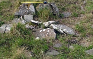
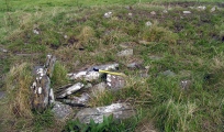
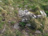
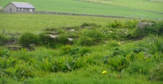
HY21SE 99 Corn is from a Norse word for cows. This grassy mound does not appear to have had specific mention before the 1998 coastal survey (assuming the cairn below Cumminess referred to in 1907 is Cummi Howe broch). EASE hazards that it is the remains of some kind of settlement, perhaps a broch (it looks equidistant between Cummi Howe broch and The Cairns 'Danish fort'/castle - though it is 8m from the cliff edge the other sites could have suffered more erosion, one tideswept and the other ? subject to undercutting - and on the other side of the water we have three brochs too) because of an apparent 15m central hollow [not so central in my image from the road]. It is some 33m by 20m and 1.6m in height. They found stone concentrations at various places and some protruding earthfast stones, also evidence of quarrying about the edge. As yet I have only viewed it from the coastal fence, where I noticed what seems to be an overgrown trench (either excavated or for sheltering stock I think) by the northern end with various materials around the sides. In the image I took the stones are mostly horizontal slabs, perhaps evidence of drystane walling. But I wish I had gone in to inspect as my images show up on the southern end a large ? orthostat and low down on the northern end a rectangular sandstone block that may have an incised line around the face of it. The orthostat's position is an unlikely one in a broch (my hazard would be pre or post "Broch Age") and the block resembles ones I connect with early kirks (there is one in a wall by Long Howe that has to come from St. Ninian's Chapel and another in the Sands of Wideford bridge I take to have come from Essonquoy). Best guess is that Corn Hillock is the result of two periods of construction.
You may be viewing yesterday's version of this page. To see the most up to date information please register for a free account.





Do not use the above information on other web sites or publications without permission of the contributor.
Click here to see more info for this site
Nearby sites
Key: Red: member's photo, Blue: 3rd party photo, Yellow: other image, Green: no photo - please go there and take one, Grey: site destroyed
Download sites to:
KML (Google Earth)
GPX (GPS waypoints)
CSV (Garmin/Navman)
CSV (Excel)
To unlock full downloads you need to sign up as a Contributory Member. Otherwise downloads are limited to 50 sites.
Turn off the page maps and other distractions
Nearby sites listing. In the following links * = Image available
374m NW 311° Cummi Howe* Broch or Nuraghe (HY282104)
633m ESE 115° The Cairns* Cairn (HY29050987)
1.2km NW 309° Howe Chambered Tomb* Chambered Tomb (HY276109)
1.6km N 352° Unstan* Chambered Cairn (HY28291172)
1.6km N 349° Diamond Cottage* Promontory Fort / Cliff Castle (HY28211176)
2.1km NW 321° Deepdale Stones* Standing Stone (Menhir) (HY272118)
2.3km NE 49° Standing Stones Hotel* Chambered Cairn (HY30251165)
2.3km WSW 237° Quoyelsh* Ancient Village or Settlement (HY265089)
2.4km NW 312° Deepdale Cottages* Standing Stones (HY267118)
2.9km NNE 16° Possible large stone circle in Loch of Stenness Stone Circle (HY2933112934)
3.0km NNE 17° Fairy Well (Stenness)* Holy Well or Sacred Spring (HY2943212982)
3.2km NNE 33° Brodgar Farm Standing Stones* Standing Stones (HY303128)
3.2km NE 42° Stenness* Stone Circle (HY30671252)
3.2km NE 39° Watch Stone (Orkney)* Standing Stone (Menhir) (HY30551264)
3.2km NNE 31° Brodgar Farm Chambered Tomb Chambered Tomb (HY302129)
3.2km NNE 14° Salt Knowe* Round Barrow(s) (HY293133)
3.3km NNE 15° South Knowe* Artificial Mound (HY29411328)
3.3km NE 35° Lochview Mound* Cairn (HY304128)
3.3km NNE 31° Ness of Brodgar* Ancient Village or Settlement (HY3024312941)
3.3km NNE 16° Ring of Brodgar* Stone Circle (HY29451335)
3.4km NNE 19° Comet Stone (Orkney)* Standing Stone (Menhir) (HY2963413318)
3.4km NE 41° Barnhouse Settlement* Ancient Village or Settlement (HY30761270)
3.4km NNE 18° Fresh Knowe* Long Barrow (HY29601339)
3.4km NE 53° Barnhouse Stone* Standing Stone (Menhir) (HY31271217)
3.5km NNE 16° Plumcake Mound* Round Barrow(s) (HY295135)
View more nearby sites and additional images




 We would like to know more about this location. Please feel free to add a brief description and any relevant information in your own language.
 Wir möchten mehr über diese Stätte erfahren. Bitte zögern Sie nicht, eine kurze Beschreibung und relevante Informationen in Deutsch hinzuzufügen.
 Nous aimerions en savoir encore un peu sur les lieux. S'il vous plaît n'hesitez pas à ajouter une courte description et tous les renseignements pertinents dans votre propre langue.
 Quisieramos informarnos un poco más de las lugares. No dude en añadir una breve descripción y otros datos relevantes en su propio idioma.