


<< Our Photo Pages >> Six Stones - Stone Circle in Wales in Powys
Submitted by Darkside on Friday, 06 June 2003 Page Views: 11323
Neolithic and Bronze AgeSite Name: Six StonesCountry: Wales County: Powys Type: Stone Circle
Nearest Town: Builth Wells
Map Ref: SO163516 Landranger Map Number: 148
Latitude: 52.156309N Longitude: 3.224887W
Condition:
| 5 | Perfect |
| 4 | Almost Perfect |
| 3 | Reasonable but with some damage |
| 2 | Ruined but still recognisable as an ancient site |
| 1 | Pretty much destroyed, possibly visible as crop marks |
| 0 | No data. |
| -1 | Completely destroyed |
| 5 | Superb |
| 4 | Good |
| 3 | Ordinary |
| 2 | Not Good |
| 1 | Awful |
| 0 | No data. |
| 5 | Can be driven to, probably with disabled access |
| 4 | Short walk on a footpath |
| 3 | Requiring a bit more of a walk |
| 2 | A long walk |
| 1 | In the middle of nowhere, a nightmare to find |
| 0 | No data. |
| 5 | co-ordinates taken by GPS or official recorded co-ordinates |
| 4 | co-ordinates scaled from a detailed map |
| 3 | co-ordinates scaled from a bad map |
| 2 | co-ordinates of the nearest village |
| 1 | co-ordinates of the nearest town |
| 0 | no data |
Internal Links:
External Links:
I have visited· I would like to visit
grandmasterglitch would like to visit
")
According to Burl this stone circle is ‘for the dedicated’! Fourteen or more low stones stand in a ring which easily becomes covered by vegetation.
22/05/2003 – Six Stones: DIRECTIONS
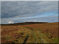
After driving through lower Glasnant you come to a short hill topped by a cattle grid – proceed through the grid and take the track to your right. Once on this track keep to the lower branch and follow it for approx 600 metres – there are a couple of place to park here without obstructing the track, we chose the disused quarry. From here continue on foot to the end of the track and proceed through the gate and up into the hills. The ground remains stony and provides fairly easy going for around 800 metres.
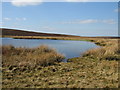
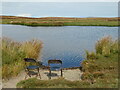
From here it is possible to follow the track up until you find yourself opposite the Mawn Pools, which will be to the direct North of you. From here you can either take the direct route over the hill and through deep bracken and marsh land, or it is possible to circumnavigate the Mawn Pools, descend the less dense part of the hill to the East, and follow the Glasnant stream back up to source; this however, is a much longer route. Either way, pay a visit to the Mawn Pools, they alone make this visit worthy.
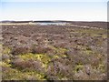
From the direct route you should emerge at the bottom of the valley near the source of the Glasnant stream. It will become immediately apparent that you are in the correct location purely by observing the context of the site. The stones are in bracken on a slightly raised plateau in the cradle of the valley, approximately 15 metres from the very source of the Glasnant stream.
There are actually far more than six stones to be found and we discovered twelve. They are about 30CM in height, and of a narrow form, however, they are not as purple as has been suggested by previous visitors, more grey. The last survey by CADW only revealed 2 – 6, so I can only assume that the site becomes very overgrown later in the year. Finally, there is a clear view East down the valley towards a notch in the skyline created by what I think is Black Hill and another, possibly providing a sight line for a sunrise at some point in the year. For anyone else planning to visit it may be interesting to try dawn and test this theory.
Rhys Davies & Andy Freeman.
You may be viewing yesterday's version of this page. To see the most up to date information please register for a free account.
Do not use the above information on other web sites or publications without permission of the contributor.
Nearby Images from Geograph Britain and Ireland:
©2007(licence)
![SO1651 : Mawn Pool [east] by Gordon Hatton](https://s0.geograph.org.uk/geophotos/07/29/77/7297708_ab2525a6_120x120.jpg)
©2022(licence)
©2022(licence)
©2007(licence)
©2022(licence)
The above images may not be of the site on this page, they are loaded from Geograph.
Please Submit an Image of this site or go out and take one for us!
Click here to see more info for this site
Nearby sites
Key: Red: member's photo, Blue: 3rd party photo, Yellow: other image, Green: no photo - please go there and take one, Grey: site destroyed
Download sites to:
KML (Google Earth)
GPX (GPS waypoints)
CSV (Garmin/Navman)
CSV (Excel)
To unlock full downloads you need to sign up as a Contributory Member. Otherwise downloads are limited to 50 sites.
Turn off the page maps and other distractions
Nearby sites listing. In the following links * = Image available
2.0km N 356° Wern Hill Camp* Hillfort (SO162536)
2.4km WSW 256° Cefn Wyfre* Stone Circle (SO14005105)
3.6km NW 321° Giant's Grave (Powys)* Round Barrow(s) (SO141544)
4.2km NNE 19° Cwmceste Barrow* Round Barrow(s) (SO1775655582)
5.1km NNE 25° Gilwern Brook Barrows* Round Barrow(s) (SO18515618)
5.2km N 351° Pedwar Maen* Stone Row / Alignment (SO156568)
5.3km N 352° Bryn-Y-Maen Barrow Round Barrow(s) (SO15665686)
5.7km N 3° Bryn-y-Maen* Standing Stone (Menhir) (SO16685728)
6.6km NNW 341° Rhos-Maen* Stone Circle (SO143579)
6.8km NNE 12° Llanfihangel Nant Melan* Standing Stone (Menhir) (SO1783258231)
7.0km N 355° Llanerch Stone* Rock Art (SO15765858)
7.1km N 358° The Van* Round Barrow(s) (SO162587)
7.1km N 355° Llanerch Stone Alignment Standing Stones (SO15775871)
7.5km NNW 343° Cwm Maerdy* Standing Stone (Menhir) (SO14205879)
7.5km NNW 334° Graig Camp* Hillfort (SO131584)
7.6km WNW 294° Perthi Common Cairns 1, 2, 3, 4* Cairn (SO0940654856)
7.7km NW 307° Cwm Stone* Standing Stone (Menhir) (SO10185630)
7.8km WNW 288° Bryntwppa* Stone Row / Alignment (SO08905410)
8.1km SE 136° Crossfoot Farm Standing Stone* Standing Stone (Menhir) (SO21874573)
8.4km WNW 292° The Gaer* Hillfort (SO08555480)
8.5km NW 307° Gwernfach Cairns I,II,III & IV* Cairn (SO096568)
8.6km WSW 256° Aberedw Hill Barrows* Barrow Cemetery (SO07914964)
8.6km WNW 288° Cilberllan Ring Cairn* Cairn (SO0815654436)
8.7km WSW 253° Cefnhinog Standing Stone* Standing Stone (Menhir) (SO07944925)
8.8km WNW 300° Castle Bank (Radnorshire)* Hillfort (SO08695608)
View more nearby sites and additional images


 We would like to know more about this location. Please feel free to add a brief description and any relevant information in your own language.
 Wir möchten mehr über diese Stätte erfahren. Bitte zögern Sie nicht, eine kurze Beschreibung und relevante Informationen in Deutsch hinzuzufügen.
 Nous aimerions en savoir encore un peu sur les lieux. S'il vous plaît n'hesitez pas à ajouter une courte description et tous les renseignements pertinents dans votre propre langue.
 Quisieramos informarnos un poco más de las lugares. No dude en añadir una breve descripción y otros datos relevantes en su propio idioma.