

<< Our Photo Pages >> Pant y Maen Round Barrow - Round Barrow(s) in Wales in Denbighshire
Submitted by TAlanJones on Sunday, 24 April 2022 Page Views: 881
Neolithic and Bronze AgeSite Name: Pant y Maen Round BarrowCountry: Wales County: Denbighshire Type: Round Barrow(s)
Nearest Town: Llangollen Nearest Village: Bryneglwys
Map Ref: SJ158477
Latitude: 53.019948N Longitude: 3.256669W
Condition:
| 5 | Perfect |
| 4 | Almost Perfect |
| 3 | Reasonable but with some damage |
| 2 | Ruined but still recognisable as an ancient site |
| 1 | Pretty much destroyed, possibly visible as crop marks |
| 0 | No data. |
| -1 | Completely destroyed |
| 5 | Superb |
| 4 | Good |
| 3 | Ordinary |
| 2 | Not Good |
| 1 | Awful |
| 0 | No data. |
| 5 | Can be driven to, probably with disabled access |
| 4 | Short walk on a footpath |
| 3 | Requiring a bit more of a walk |
| 2 | A long walk |
| 1 | In the middle of nowhere, a nightmare to find |
| 0 | No data. |
| 5 | co-ordinates taken by GPS or official recorded co-ordinates |
| 4 | co-ordinates scaled from a detailed map |
| 3 | co-ordinates scaled from a bad map |
| 2 | co-ordinates of the nearest village |
| 1 | co-ordinates of the nearest town |
| 0 | no data |
Internal Links:
External Links:
")
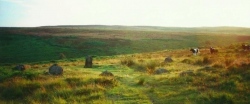
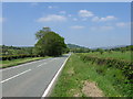
Situated at the edge of a field the Barrow has been truncated on the WE side by a narrow public road that leads from the A5104 towards the A5. The barrow is a typical earthen built mound dating from the Bronze Age period. It has been scheduled as a national monument and there is a strong possibility of intact burial and ritual deposits.
The mound is approximately 16m in diameter NE-SW, 11.5m NW-SE and 1.5m high. A standing stone stands 1.5m on the summit of the mound. Apparently the stone was removed and used as a gate post in the 1800's but thankfully replaced some time later. However, a yew tree was planted on the site and both the stone and the barrow are now mostly concealled.
The surrounding area has a number of barrows in close proximity to each other. Barrows may be part of a larger cluster of monuments and their importance is enhanced by their group value.
You may be viewing yesterday's version of this page. To see the most up to date information please register for a free account.
")
")
")
")
Do not use the above information on other web sites or publications without permission of the contributor.
Nearby Images from Geograph Britain and Ireland:

©2013(licence)
©2012(licence)
©2019(licence)
©2019(licence)
©2010(licence)
The above images may not be of the site on this page, they are loaded from Geograph.
Please Submit an Image of this site or go out and take one for us!
Click here to see more info for this site
Nearby sites
Key: Red: member's photo, Blue: 3rd party photo, Yellow: other image, Green: no photo - please go there and take one, Grey: site destroyed
Download sites to:
KML (Google Earth)
GPX (GPS waypoints)
CSV (Garmin/Navman)
CSV (Excel)
To unlock full downloads you need to sign up as a Contributory Member. Otherwise downloads are limited to 50 sites.
Turn off the page maps and other distractions
Nearby sites listing. In the following links * = Image available
538m NNE 21° Ty Mawr Round Barrows* Barrow Cemetery (SJ160482)
1.6km SE 145° Moel-y-Gaer (Llangollen)* Hillfort (SJ16704636)
1.8km N 8° Rhos Lydan Round Barrows* Barrow Cemetery (SJ161495)
2.2km ESE 122° Moel Gamelin* Cairn (SJ17624651)
3.7km E 84° St Collen's Well* Holy Well or Sacred Spring (SJ195480)
4.6km WNW 286° Tom Dongen Round Barrow* Round Barrow(s) (SJ1137049060)
5.1km ENE 76° Cryn-y-Brain* Cairn (SJ20814888)
5.4km W 260° Bwrdd y Tri Arglwydd* Chambered Tomb (SJ10454682)
5.5km SE 125° Pillar of Eliseg* Early Christian Sculptured Stone (SJ20264452)
5.5km SSW 212° Owain Glyndwr's House (Site of)* Rock Art (SJ12754309)
5.6km N 10° Moel Y Waun Round Cairn South* Round Cairn (SJ169532)
5.7km N 10° Moel Y Waun Round Cairn North* Round Cairn (SJ169533)
5.8km NE 38° St Tecla's Well* Holy Well or Sacred Spring (SJ194522)
6.5km SSW 198° Cwm Ganol Cairn* Round Cairn (SJ13674151)
6.5km SSW 198° Cwm Ganol Standing Stone* Standing Stone (Menhir) (SJ13674151)
6.6km NE 50° Plough Inn Round Barrow(s) (SJ20945182)
6.6km NNE 26° Rhos Isaf Cave* Cave or Rock Shelter (SJ18845355)
6.6km NNE 26° Perthi Chwarae Farm Cave 1 Cave or Rock Shelter (SJ18795363)
6.7km SSW 213° Carrog Uchaf Round Barrows* Round Barrow(s) (SJ1210042150)
7.0km ESE 112° Creigiau Eglwyseg 1* Round Barrow(s) (SJ22214495)
7.0km SSW 201° Plasnewydd Round Cairns* Round Cairn (SJ1316641192)
7.3km ESE 115° Eglwyseg Plantation Barrow* Round Barrow(s) (SJ22364446)
7.4km ESE 112° Eglwyseg Stone* Natural Stone / Erratic / Other Natural Feature (SJ22574478)
7.4km ESE 110° Eglwyseg Kerb Cairn B* Cairn (SJ227451)
7.4km ESE 110° Eglwyseg Kerb Cairn A* Cairn (SJ22704509)
View more nearby sites and additional images


 We would like to know more about this location. Please feel free to add a brief description and any relevant information in your own language.
 Wir möchten mehr über diese Stätte erfahren. Bitte zögern Sie nicht, eine kurze Beschreibung und relevante Informationen in Deutsch hinzuzufügen.
 Nous aimerions en savoir encore un peu sur les lieux. S'il vous plaît n'hesitez pas à ajouter une courte description et tous les renseignements pertinents dans votre propre langue.
 Quisieramos informarnos un poco más de las lugares. No dude en añadir una breve descripción y otros datos relevantes en su propio idioma.