 with our Megalithic Portal iPhone app")


<< Our Photo Pages >> St Tecla's Well - Holy Well or Sacred Spring in Wales in Denbighshire
Submitted by KiwiBetsy on Sunday, 28 November 2004 Page Views: 11623
Springs and Holy WellsSite Name: St Tecla's Well Alternative Name: Ffynnon Tegla, St Thecla's WellCountry: Wales County: Denbighshire Type: Holy Well or Sacred Spring
Map Ref: SJ194522
Latitude: 53.060945N Longitude: 3.204141W
Condition:
| 5 | Perfect |
| 4 | Almost Perfect |
| 3 | Reasonable but with some damage |
| 2 | Ruined but still recognisable as an ancient site |
| 1 | Pretty much destroyed, possibly visible as crop marks |
| 0 | No data. |
| -1 | Completely destroyed |
| 5 | Superb |
| 4 | Good |
| 3 | Ordinary |
| 2 | Not Good |
| 1 | Awful |
| 0 | No data. |
| 5 | Can be driven to, probably with disabled access |
| 4 | Short walk on a footpath |
| 3 | Requiring a bit more of a walk |
| 2 | A long walk |
| 1 | In the middle of nowhere, a nightmare to find |
| 0 | No data. |
| 5 | co-ordinates taken by GPS or official recorded co-ordinates |
| 4 | co-ordinates scaled from a detailed map |
| 3 | co-ordinates scaled from a bad map |
| 2 | co-ordinates of the nearest village |
| 1 | co-ordinates of the nearest town |
| 0 | no data |
Internal Links:
External Links:
")
Although St Tecla is still honoured on her feast day in September the well itself appeared long neglected.
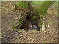
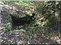
It is to be found on the low flat area on the north bank of the River Alyn, east of the bridge south of the village but is best accessed via Mill Farm (with permission). Only the two foot square stone lined well basin remains in an area thick with trees and in May 2003 was all but unrecognisable, being clogged with weeds, slime and dead and rotting branches.
Some clearing was required to reveal the stone basin and drainage channel in the picture but we were rewarded with the sight of a small but definite seeping of clear water into the muddy basin and the struggling ferns were ready to stake their claim with the aid of the new found sunlight.
The most recent documented cure was in 1813 when the church sextons son was relieved of his epilepsy. The church has subsequently discouraged use of the well, considering it pagan but they do have a display featuring the well and it’s history.
Those hoping for a cure had to bathe in the well after sunset, walk around the well nine times carrying a rooster while reciting the Lord’s Prayer, walk around the church nine times again reciting the Lord’s Prayer before entering the church and sleeping for the night under the altar clutching the rooster and using the bible as a pillow. In the morning they stuck pins into the unfortunate rooster before tossing them into the well and placing the birds beak into their mouth for transfer of the disease to the bird. The rooster was then left in the church. If it died one could expect ones cure. Of course, remember to change your rooster to a hen if your sufferer is female.
You may be viewing yesterday's version of this page. To see the most up to date information please register for a free account.
Do not use the above information on other web sites or publications without permission of the contributor.
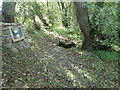
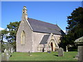
Nearby Images from Geograph Britain and Ireland:
©2007(licence)
©2020(licence)
©2020(licence)

©2007(licence)
©2006(licence)
The above images may not be of the site on this page, they are loaded from Geograph.
Please Submit an Image of this site or go out and take one for us!
Click here to see more info for this site
Nearby sites
Key: Red: member's photo, Blue: 3rd party photo, Yellow: other image, Green: no photo - please go there and take one, Grey: site destroyed
Download sites to:
KML (Google Earth)
GPX (GPS waypoints)
CSV (Garmin/Navman)
CSV (Excel)
To unlock full downloads you need to sign up as a Contributory Member. Otherwise downloads are limited to 50 sites.
Turn off the page maps and other distractions
Nearby sites listing. In the following links * = Image available
1.5km NNW 337° Rhos Isaf Cave* Cave or Rock Shelter (SJ18845355)
1.6km NNW 336° Perthi Chwarae Farm Cave 1 Cave or Rock Shelter (SJ18795363)
1.6km ESE 103° Plough Inn Round Barrow(s) (SJ20945182)
2.7km WNW 291° Moel Y Waun Round Cairn South* Round Cairn (SJ169532)
2.7km WNW 293° Moel Y Waun Round Cairn North* Round Cairn (SJ169533)
3.3km NE 39° Llyn Cyfynwy Round Cairn* Round Cairn (SJ215547)
3.6km SSE 156° Cryn-y-Brain* Cairn (SJ20814888)
3.7km N 359° Cefn Canol* Round Barrow(s) (SJ194559)
3.8km N 359° Tomen Y Faerdre Standing Stone* Standing Stone (Menhir) (SJ194560)
3.9km E 84° Maes Maelor* Barrow Cemetery (SJ23275255)
4.0km N 355° Llanarmon Yn Ial (St Garmon)* Stone Circle (SJ1912656153)
4.0km NW 324° Moel Y Plas Tumulus* Round Cairn (SJ171555)
4.1km N 358° Llanarmon Cave Cave or Rock Shelter (SJ1933956265)
4.2km S 178° St Collen's Well* Holy Well or Sacred Spring (SJ195480)
4.3km SW 230° Rhos Lydan Round Barrows* Barrow Cemetery (SJ161495)
4.4km NW 323° Llanarmon Yn Lal Burial Mounds* Round Barrow(s) (SJ168558)
4.8km ESE 121° Aber Sychnant* Cairn (SJ23454963)
5.0km ESE 119° Cefn-y-Gader cairn (2)* Cairn (SJ23774971)
5.2km SW 219° Ty Mawr Round Barrows* Barrow Cemetery (SJ160482)
5.6km ESE 122° Cefn-y-Gader cairn 1* Cairn (SJ241492)
5.8km SW 218° Pant y Maen Round Barrow* Round Barrow(s) (SJ158477)
5.8km NNW 337° Moel Gwy Tumulus* Round Cairn (SJ172576)
6.0km SSW 196° Moel Gamelin* Cairn (SJ17624651)
6.4km SSW 204° Moel-y-Gaer (Llangollen)* Hillfort (SJ16704636)
7.0km NE 40° Pentre Round Barrow* Round Barrow(s) (SJ2401057440)
View more nearby sites and additional images


 We would like to know more about this location. Please feel free to add a brief description and any relevant information in your own language.
 Wir möchten mehr über diese Stätte erfahren. Bitte zögern Sie nicht, eine kurze Beschreibung und relevante Informationen in Deutsch hinzuzufügen.
 Nous aimerions en savoir encore un peu sur les lieux. S'il vous plaît n'hesitez pas à ajouter une courte description et tous les renseignements pertinents dans votre propre langue.
 Quisieramos informarnos un poco más de las lugares. No dude en añadir una breve descripción y otros datos relevantes en su propio idioma.