<< Our Photo Pages >> Moel Ty Uchaf - Stone Circle in Wales in Denbighshire
Submitted by Vicky on Tuesday, 10 November 2020 Page Views: 55577
Neolithic and Bronze AgeSite Name: Moel Ty UchafCountry: Wales County: Denbighshire Type: Stone Circle
Nearest Town: Bala Nearest Village: Llandrillo
Map Ref: SJ05613717 Landranger Map Number: 125
Latitude: 52.923618N Longitude: 3.405455W
Condition:
| 5 | Perfect |
| 4 | Almost Perfect |
| 3 | Reasonable but with some damage |
| 2 | Ruined but still recognisable as an ancient site |
| 1 | Pretty much destroyed, possibly visible as crop marks |
| 0 | No data. |
| -1 | Completely destroyed |
| 5 | Superb |
| 4 | Good |
| 3 | Ordinary |
| 2 | Not Good |
| 1 | Awful |
| 0 | No data. |
| 5 | Can be driven to, probably with disabled access |
| 4 | Short walk on a footpath |
| 3 | Requiring a bit more of a walk |
| 2 | A long walk |
| 1 | In the middle of nowhere, a nightmare to find |
| 0 | No data. |
| 5 | co-ordinates taken by GPS or official recorded co-ordinates |
| 4 | co-ordinates scaled from a detailed map |
| 3 | co-ordinates scaled from a bad map |
| 2 | co-ordinates of the nearest village |
| 1 | co-ordinates of the nearest town |
| 0 | no data |
Internal Links:
External Links:
I have visited· I would like to visit
NickiMacRae 43559959 Traumrealistin SumDoood PAB KieKa whese001 MicheleW elad13 Orcinus Gryffincoch cappy would like to visit
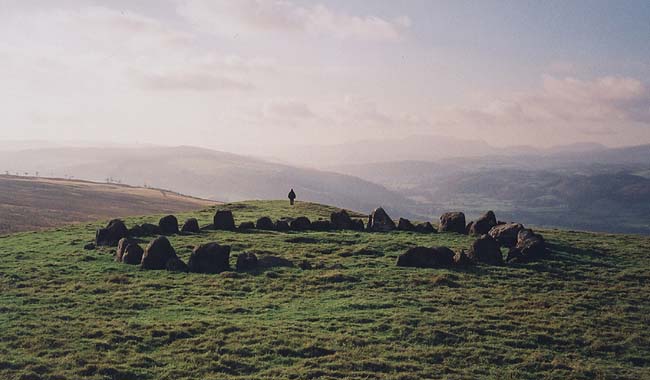
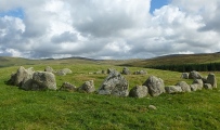
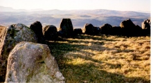
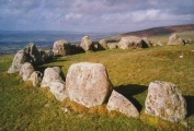
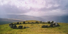
drolaf visited on 7th May 2025 - their rating: Cond: 4 Amb: 5 Access: 2 Lovely ring cairn with stunning long distance views to nww Fader Goch? and to nee .
On a hill about half way up to the peak at Cader Bronwen on the north west slope.
41 stones from 1 foot to 2.5 ft high. Two gaps with small stones in them maybe had larger ones in once.
The large (fallen?) outlier is to the west.
A slow slog for an old un from Llandrillo but a great walk -saw some small bouncy deer (maybe muntjac).
Marko visited on 24th Apr 2021 - their rating: Cond: 4 Amb: 5 Access: 2
BolshieBoris visited on 1st Jan 2021 - their rating: Cond: 5 Amb: 5 Access: 2 Not a long walk, but very arduous and up a fairly steep rough track, but worth it, awesome views, note from the 1:25000 OS map the nearest parking place (end of the road) is 2 fields away.
DJMace visited on 9th Nov 2020 - their rating: Amb: 5
bishop_pam visited on 20th Aug 2020 - their rating: Cond: 5 Amb: 5 Access: 3 I also visited this in February 2016
w650marion visited on 21st Dec 2019 - their rating: Cond: 4 Amb: 5 Access: 3 Joined the Midwinter Solstice Walk up to Moel Ty Uchaf organised by Chris at Corwen and Dee Valley Archaeological Society. We were fortunate to have a weather window in the constant rain so we could enjoy the views and take photos.
markhewins visited on 10th Jun 2015 Wonderful day. Special moments.
https://www.flickr.com/photos/37511372@N08/24486757185
Marko visited on 26th Mar 2014 - their rating: Cond: 4 Amb: 5 Access: 2 Superb.Part of a 10 mile walk taking in other sites.Snow further on!
shawid visited on 19th Mar 2014 - their rating: Cond: 4 Amb: 5 Access: 2
Jimwithnoname visited on 19th Aug 2011 - their rating: Cond: 4 Amb: 5 Access: 2
rjcm visited on 3rd Oct 2009 - their rating: Cond: 5 Amb: 5 Access: 2
BolshieBoris visited on 1st Jun 2009 - their rating: Cond: 5 Amb: 5 Access: 3 Not a long walk, but very arduous and up a fairly steep rough track, but worth it, awesome views, note from the 1:25000 OS map the nearest parking place (end of the road) is 2 fields away.
Penbron Bladup cerrig TimPrevett AngieLake have visited here
Average ratings for this site from all visit loggers: Condition: 4.4 Ambience: 5 Access: 2.3

According to Burl it is ‘almost perfect’.
You may be viewing yesterday's version of this page. To see the most up to date information please register for a free account.









These are just the first 25 photos of Moel Ty Uchaf. If you log in with a free user account you will be able to see our entire collection.
Do not use the above information on other web sites or publications without permission of the contributor.
Click here to see more info for this site
Nearby sites
Key: Red: member's photo, Blue: 3rd party photo, Yellow: other image, Green: no photo - please go there and take one, Grey: site destroyed
Download sites to:
KML (Google Earth)
GPX (GPS waypoints)
CSV (Garmin/Navman)
CSV (Excel)
To unlock full downloads you need to sign up as a Contributory Member. Otherwise downloads are limited to 50 sites.
Turn off the page maps and other distractions
Nearby sites listing. In the following links * = Image available
1.1km SSE 165° Cerrig Bwlch Y Fedw* Stone Circle (SJ05873615)
1.2km SSE 153° Bwlch y Fedw Standing Stone* Standing Stone (Menhir) (SJ0614036100)
1.3km SSE 157° Moel Pearce Standing Stone* Standing Stone (Menhir) (SJ0609036000)
1.9km SSW 214° Gwern Wynodl Cairns* Cairn (SJ0455035640)
2.2km SSW 204° Clochnant Platforms* Ancient Village or Settlement (SJ0469035200)
2.6km NNW 340° Tyn y Coed* Chambered Cairn (SJ0476839603)
2.8km SSW 197° Ffridd Camen Ring Cairn* Ring Cairn (SJ0474034470)
2.9km E 97° Pen Bwlch Llandrillo Cairn (SJ08513674)
3.2km WNW 299° Tyfos* Stone Circle (SJ02843876)
3.2km SE 139° Bwrdd Arthur* Cairn (SJ077347)
3.6km E 100° Careg-Y-Caws* Cairn (SJ09133650)
3.6km SW 216° Penagored Standing Stone* Standing Stone (Menhir) (SJ034343)
3.8km SSW 193° Cwm Tywyll* Ring Cairn (SJ04683346)
3.9km S 190° Pennant* Round Cairn (SJ04823331)
4.0km SSW 204° Cefn Penagored Cairn and Ring Cairn* Cairn (SJ039336)
4.0km SSW 201° Cefn Penagored Ridge Cairns* Cairn (SJ041335)
4.2km SE 145° Bwlch Maen Gwynedd* Cairn (SJ07953364)
4.2km SE 143° Tomple Standing Stone, Y Berwyn* Standing Stone (Menhir) (SJ0807633718)
4.4km SSE 149° Berwyn mountains Marker stones* Marker Stone (SJ078334)
4.4km SSW 195° Nant Esgeiriau* Round Cairn (SJ044329)
4.5km W 273° Branas Uchaf* Chambered Cairn (SJ01123752)
4.5km SSW 210° Rhyd y Gethin Standing Stone (Menhir) (SJ03303330)
4.6km WSW 252° Craig yr Arian* Chambered Cairn (SJ01243584)
4.6km ENE 65° Nant Croes Y Wernen* Stone Circle (SJ09813906)
4.7km SSE 159° Cadair Berwyn* Cairn (SJ072327)
View more nearby sites and additional images


 We would like to know more about this location. Please feel free to add a brief description and any relevant information in your own language.
 Wir möchten mehr über diese Stätte erfahren. Bitte zögern Sie nicht, eine kurze Beschreibung und relevante Informationen in Deutsch hinzuzufügen.
 Nous aimerions en savoir encore un peu sur les lieux. S'il vous plaît n'hesitez pas à ajouter une courte description et tous les renseignements pertinents dans votre propre langue.
 Quisieramos informarnos un poco más de las lugares. No dude en añadir una breve descripción y otros datos relevantes en su propio idioma.