

<< Our Photo Pages >> Slewcairn SW - Cairn in Scotland in Dumfries and Galloway
Submitted by markj99 on Wednesday, 27 January 2021 Page Views: 567
Neolithic and Bronze AgeSite Name: Slewcairn SWCountry: Scotland County: Dumfries and Galloway Type: Cairn
Nearest Town: Dalbeattie Nearest Village: New Abbey
Map Ref: NX92766133
Latitude: 54.935078N Longitude: 3.675309W
Condition:
| 5 | Perfect |
| 4 | Almost Perfect |
| 3 | Reasonable but with some damage |
| 2 | Ruined but still recognisable as an ancient site |
| 1 | Pretty much destroyed, possibly visible as crop marks |
| 0 | No data. |
| -1 | Completely destroyed |
| 5 | Superb |
| 4 | Good |
| 3 | Ordinary |
| 2 | Not Good |
| 1 | Awful |
| 0 | No data. |
| 5 | Can be driven to, probably with disabled access |
| 4 | Short walk on a footpath |
| 3 | Requiring a bit more of a walk |
| 2 | A long walk |
| 1 | In the middle of nowhere, a nightmare to find |
| 0 | No data. |
| 5 | co-ordinates taken by GPS or official recorded co-ordinates |
| 4 | co-ordinates scaled from a detailed map |
| 3 | co-ordinates scaled from a bad map |
| 2 | co-ordinates of the nearest village |
| 1 | co-ordinates of the nearest town |
| 0 | no data |
Internal Links:
External Links:
")
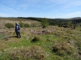
Slewcairn SW is one of a pair of cairns situated c. 0.25 miles E of Slewcairn Long Cairn. It is almost completely robbed of stones on a rig c. 60 yards SW of the forest track at NX 92824 61374. According to Canmore ID 65492 it measures 10 yards across and up to 1 yard high. It is heather covered with a small scattering of stones on top. A modern cairn c. 2 feet high has been built on top of the cairn.
Slewcairn NE, its near neighbour, lies about 130 yards NE hidden in the trees.
I visited the Slewcairn complex on 12.05.12.
You may be viewing yesterday's version of this page. To see the most up to date information please register for a free account.
")
")
")
Do not use the above information on other web sites or publications without permission of the contributor.
Nearby Images from Geograph Britain and Ireland:
©2010(licence)
©2013(licence)
©2015(licence)
©2010(licence)
©2015(licence)
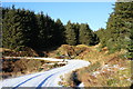
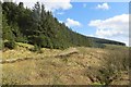
The above images may not be of the site on this page, they are loaded from Geograph.
Please Submit an Image of this site or go out and take one for us!
Click here to see more info for this site
Nearby sites
Key: Red: member's photo, Blue: 3rd party photo, Yellow: other image, Green: no photo - please go there and take one, Grey: site destroyed
Download sites to:
KML (Google Earth)
GPX (GPS waypoints)
CSV (Garmin/Navman)
CSV (Excel)
To unlock full downloads you need to sign up as a Contributory Member. Otherwise downloads are limited to 50 sites.
Turn off the page maps and other distractions
Nearby sites listing. In the following links * = Image available
128m NE 37° Slewcairn NE* Cairn (NX92846143)
397m WNW 294° Slewcairn* Cairn (NX924615)
4.4km SSE 161° Kells Standing Stone* Standing Stone (Menhir) (NX94075709)
4.7km SSE 164° Home Farm Stones* Standing Stones (NX93965677)
5.0km NE 53° Loch Kindar Crannog (NX96896423)
5.3km ESE 113° Glebe Well Holy Well or Sacred Spring (NX9759159178)
5.6km NE 46° Lochhill* Chambered Cairn (NX96886507)
6.5km ENE 57° Ingleston Cairn (NX983647)
7.8km SW 215° Newbarns Passage Grave and Cairns* Passage Grave (NX88105505)
8.2km NW 310° Kirkgunzeon Stone Circle (NX86576668)
8.4km NW 311° St Winning's Well (Kirkgunzeon)* Holy Well or Sacred Spring (NX86526699)
11.0km SW 227° Motte of Mark* Hillfort (NX8450454023)
11.1km ENE 60° Ward Law* Hillfort (NY0245766692)
11.1km NNE 12° Picts Knowe* Henge (NX95387213)
11.2km NNE 13° St Queran's Well* Holy Well or Sacred Spring (NX95597222)
11.4km W 270° Slot Well (Buittle) Holy Well or Sacred Spring (NX8134861618)
12.0km NNW 345° Lochrutton Loch* Crannog (NX89837299)
12.2km W 270° Rumbling Well (Buittle) Holy Well or Sacred Spring (NX8050061547)
12.6km N 355° Easthill* Stone Circle (NX91937388)
13.0km NW 318° Milton Loch SE* Crannog (NX84287120)
13.4km NW 318° Milton Loch Central* Crannog (NX83947149)
13.6km NW 318° Green Island (Milton Loch)* Misc. Earthwork (NX83857164)
13.8km NW 319° Milton Loch NW* Crannog (NX83887188)
14.0km WSW 243° St Mirrans Well (Kelton) Holy Well or Sacred Spring (NX80045535)
14.1km N 11° Troqueer Cursus Cursus (NX95837512)
View more nearby sites and additional images


 We would like to know more about this location. Please feel free to add a brief description and any relevant information in your own language.
 Wir möchten mehr über diese Stätte erfahren. Bitte zögern Sie nicht, eine kurze Beschreibung und relevante Informationen in Deutsch hinzuzufügen.
 Nous aimerions en savoir encore un peu sur les lieux. S'il vous plaît n'hesitez pas à ajouter une courte description et tous les renseignements pertinents dans votre propre langue.
 Quisieramos informarnos un poco más de las lugares. No dude en añadir una breve descripción y otros datos relevantes en su propio idioma.