<< Our Photo Pages >> South Harton Cross - Ancient Cross in England in Devon
Submitted by Anne T on Sunday, 02 June 2019 Page Views: 1691
Early Medieval (Dark Age)Site Name: South Harton Cross Alternative Name: South Harton Farm CrossCountry: England County: Devon Type: Ancient Cross
Nearest Town: Moretonhampstead / Bovey Tracey Nearest Village: Lustleigh
Map Ref: SX7724982273
Latitude: 50.627198N Longitude: 3.736839W
Condition:
| 5 | Perfect |
| 4 | Almost Perfect |
| 3 | Reasonable but with some damage |
| 2 | Ruined but still recognisable as an ancient site |
| 1 | Pretty much destroyed, possibly visible as crop marks |
| 0 | No data. |
| -1 | Completely destroyed |
| 5 | Superb |
| 4 | Good |
| 3 | Ordinary |
| 2 | Not Good |
| 1 | Awful |
| 0 | No data. |
| 5 | Can be driven to, probably with disabled access |
| 4 | Short walk on a footpath |
| 3 | Requiring a bit more of a walk |
| 2 | A long walk |
| 1 | In the middle of nowhere, a nightmare to find |
| 0 | No data. |
| 5 | co-ordinates taken by GPS or official recorded co-ordinates |
| 4 | co-ordinates scaled from a detailed map |
| 3 | co-ordinates scaled from a bad map |
| 2 | co-ordinates of the nearest village |
| 1 | co-ordinates of the nearest town |
| 0 | no data |
Internal Links:
External Links:
I have visited· I would like to visit
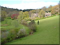
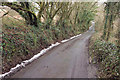
Anne T visited on 11th May 2019 - their rating: Cond: 3 Amb: 4 Access: 5 South Harton Wayside Cross: As we drove along the minor roads from the Bishop’s Stone towards South Harton Farm, the sun went in and a haze started to drift across the fields and it started to become very chilly.
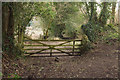
This cross simply leans against the dry stone wall, just to the west of the gated driveway leading to South Harton Farm. It has very obviously been cemented together, but is none-the-less spectacular, and I’m glad we braved the narrow lane to find this cross.
Out of curiosity, I walked to the gate and looked to see if the cross was visible from the other side of the wall, but it is hidden by the drystone wall and the hedge.
")
This wayside cross is recorded as Pastscape Monument No. 445594 and Historic England List ID 1097399. Dated as being "probably medieval", Historic England tells us this granite cross tapers slightly, has the worn stumps of its original arms and heads, and is badly worn.
Pastscape adds that the cross is 6.25ft tall and 13 inches wide; its arms project 3 inches on either side of the head and it has been split down the middle and re-joined.
Source of the information in the first paragraph: F.H. Starkey's 1983 book "Dartmoor Crosses & Some Ancient Tracks"
You may be viewing yesterday's version of this page. To see the most up to date information please register for a free account.
")
")
Do not use the above information on other web sites or publications without permission of the contributor.
Nearby Images from Geograph Britain and Ireland:

©2019(licence)
©2006(licence)
©2018(licence)

©2012(licence)
©2018(licence)
The above images may not be of the site on this page, they are loaded from Geograph.
Please Submit an Image of this site or go out and take one for us!
Click here to see more info for this site
Nearby sites
Key: Red: member's photo, Blue: 3rd party photo, Yellow: other image, Green: no photo - please go there and take one, Grey: site destroyed
Download sites to:
KML (Google Earth)
GPX (GPS waypoints)
CSV (Garmin/Navman)
CSV (Excel)
To unlock full downloads you need to sign up as a Contributory Member. Otherwise downloads are limited to 50 sites.
Turn off the page maps and other distractions
Nearby sites listing. In the following links * = Image available
576m ENE 62° Higher Combe Cross* Ancient Cross (SX7776482535)
1.1km W 276° Hunter's Tor Fort* Hillfort (SX7616482412)
1.4km NNW 341° Sanduck Cross* Ancient Cross (SX7681983610)
1.5km ESE 117° Bishop's Stone (Lustleigh)* Ancient Cross (SX7860281532)
1.6km SE 127° Datuidoc's Stone* Early Christian Sculptured Stone (SX7850081274)
3.1km S 190° Trendlebere Down* Multiple Stone Rows / Avenue (SX76627928)
3.1km S 190° Trendlebere Down Stone Row Cairn* Cairn (SX7662079230)
3.3km NNW 341° One Mill Bridge Cross* Ancient Cross (SX76268544)
3.6km WNW 295° North Bovey* Ancient Cross (SX7399083879)
3.6km WSW 239° Bowerman's Nose* Rock Outcrop (SX74108046)
3.6km SSW 195° Black Hill Cairns* Cairn (SX762788)
3.8km E 82° Tottiford Reservoir* Standing Stones (SX810827)
3.8km NW 309° Horspit Cross* Ancient Cross (SX7430684741)
3.9km W 269° Easdon Hill Ring Cairn (SX73358231)
3.9km ENE 75° Tottiford Reservoir Row N* Stone Row / Alignment (SX81078320)
3.9km ENE 76° Tottiford Reservoir circle* Stone Circle (SX81098314)
3.9km ENE 76° Tottiford Reservoir mound* Ancient Village or Settlement (SX81118313)
4.0km ENE 77° Tottiford Reservoir Row S* Stone Row / Alignment (SX81138309)
4.0km ENE 76° Tottiford Reservoir cairns* Cairn (SX81138312)
4.1km NNW 334° Moretonhampstead Cross* Ancient Cross (SX7550886039)
4.2km S 187° Haytor Down Ring Cairn (SX76617814)
4.4km SW 216° Hound Tor Deserted Medieval Village* Ancient Village or Settlement (SX74627878)
4.4km SSW 201° Smallacombe Rocks Settlement* Ancient Village or Settlement (SX7558378211)
4.4km SW 220° Hound Tor Enclosure* Causewayed Enclosure (SX74307897)
4.7km SW 221° Hound Tor Ring Cairn* Ring Cairn (SX7409778770)
View more nearby sites and additional images


 We would like to know more about this location. Please feel free to add a brief description and any relevant information in your own language.
 Wir möchten mehr über diese Stätte erfahren. Bitte zögern Sie nicht, eine kurze Beschreibung und relevante Informationen in Deutsch hinzuzufügen.
 Nous aimerions en savoir encore un peu sur les lieux. S'il vous plaît n'hesitez pas à ajouter une courte description et tous les renseignements pertinents dans votre propre langue.
 Quisieramos informarnos un poco más de las lugares. No dude en añadir una breve descripción y otros datos relevantes en su propio idioma.