<< Our Photo Pages >> Clach-a-Mharsain - Standing Stone (Menhir) in Scotland in Perth and Kinross
Submitted by nicoladidsbury on Sunday, 18 April 2010 Page Views: 5196
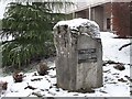
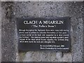
Neolithic and Bronze AgeSite Name: Clach-a-Mharsain Alternative Name: Stone of the PackmanCountry: Scotland County: Perth and Kinross Type: Standing Stone (Menhir)
Nearest Town: Pitlochry Nearest Village: Kinloch Rannoch
Map Ref: NN65385892
Latitude: 56.702525N Longitude: 4.200295W
Condition:
| 5 | Perfect |
| 4 | Almost Perfect |
| 3 | Reasonable but with some damage |
| 2 | Ruined but still recognisable as an ancient site |
| 1 | Pretty much destroyed, possibly visible as crop marks |
| 0 | No data. |
| -1 | Completely destroyed |
| 5 | Superb |
| 4 | Good |
| 3 | Ordinary |
| 2 | Not Good |
| 1 | Awful |
| 0 | No data. |
| 5 | Can be driven to, probably with disabled access |
| 4 | Short walk on a footpath |
| 3 | Requiring a bit more of a walk |
| 2 | A long walk |
| 1 | In the middle of nowhere, a nightmare to find |
| 0 | No data. |
| 5 | co-ordinates taken by GPS or official recorded co-ordinates |
| 4 | co-ordinates scaled from a detailed map |
| 3 | co-ordinates scaled from a bad map |
| 2 | co-ordinates of the nearest village |
| 1 | co-ordinates of the nearest town |
| 0 | no data |
Internal Links:
External Links:
I have visited· I would like to visit
nicoladidsbury has visited here
")
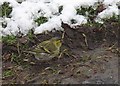
Clach-a-Mharsain which means the ‘Stone of the Packman’. The legend tell of a wandering pedlar who had been travelling with a pack slung over his shoulders. He sat down by the stone to rest, putting his pack on top of it, it slipped down the back of the stone and the loop at the front caught round his neck. The heavy pack trapped him and he died of strangulation.
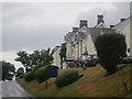
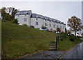
The stone is on the edge of the grounds of the MacDonald Loch Rannoch Hotel. and is hard to miss, though I did, and had to ask the receptionist where it was.....
You may be viewing yesterday's version of this page. To see the most up to date information please register for a free account.
Do not use the above information on other web sites or publications without permission of the contributor.
Nearby Images from Geograph Britain and Ireland:
©2008(licence)
©2008(licence)
©2013(licence)
©2014(licence)
©2008(licence)
The above images may not be of the site on this page, they are loaded from Geograph.
Please Submit an Image of this site or go out and take one for us!
Click here to see more info for this site
Nearby sites
Key: Red: member's photo, Blue: 3rd party photo, Yellow: other image, Green: no photo - please go there and take one, Grey: site destroyed
Download sites to:
KML (Google Earth)
GPX (GPS waypoints)
CSV (Garmin/Navman)
CSV (Excel)
To unlock full downloads you need to sign up as a Contributory Member. Otherwise downloads are limited to 50 sites.
Turn off the page maps and other distractions
Nearby sites listing. In the following links * = Image available
1.9km ESE 118° Clach na Boile* Standing Stone (Menhir) (NN6698957985)
2.1km ESE 109° Seomar na Stainge Cairn (NN67365818)
3.7km W 269° Clach na h' Iobairte* Standing Stone (Menhir) (NN6170158973)
5.8km E 99° Craigh na Dun* Modern Stone Circle etc (NN7105657815)
7.4km ESE 106° Allt Leathan Ancient Village or Settlement (NN72465659)
7.5km ESE 106° Allt Leathan Stone Standing Stone (Menhir) (NN72515659)
9.5km ENE 75° Upper Gaskan* Stone Circle (NN74666113)
11.4km S 173° Dericambus Standing Stone (Menhir) (NN66484757)
11.6km SSW 192° St Palladius' Footprint (Camusvrachan)* Natural Stone / Erratic / Other Natural Feature (NN6262647685)
11.6km SSW 192° St Adamnan's Cross* Ancient Cross (NN62534768)
12.2km E 98° Tombreck Standing Stone (Menhir) (NN77445693)
12.5km SSE 151° Coille Dhubh Standing Stones (NN711478)
13.0km ENE 66° Kinaldy Standing Stone (Menhir) (NN774639)
13.2km SSW 198° Glen Lyon - Praying Hands of Mary* Natural Stone / Erratic / Other Natural Feature (NN610465)
14.0km SSW 208° Kerrowmore Stone Circle (NN583468)
14.5km SSE 147° Bridge of Lyon long cairn* Long Barrow (NN72964655)
14.5km SE 143° Fortingall Modern Stone Circle* Modern Stone Circle etc (NN73754703)
14.6km SE 146° Lyon Bridge Cairn* Cairn (NN73174657)
14.7km SSE 146° Bridge of Lyon Standing Stones* Standing Stones (NN73144641)
14.8km SE 142° Clach a' Phlaigh* Standing Stone (Menhir) (NN74064693)
14.8km SE 142° Fortingall church crosses* Ancient Cross (NN74204702)
15.0km SE 141° Fortingall NE* Stone Circle (NN7453546977)
15.0km SE 141° Fortingall SW* Stone Circle (NN7451446960)
15.1km SE 141° Fortingall S* Stone Circle (NN7454746927)
15.3km SSE 151° Cromrar 1* Rock Art (NN72474531)
View more nearby sites and additional images


 We would like to know more about this location. Please feel free to add a brief description and any relevant information in your own language.
 Wir möchten mehr über diese Stätte erfahren. Bitte zögern Sie nicht, eine kurze Beschreibung und relevante Informationen in Deutsch hinzuzufügen.
 Nous aimerions en savoir encore un peu sur les lieux. S'il vous plaît n'hesitez pas à ajouter une courte description et tous les renseignements pertinents dans votre propre langue.
 Quisieramos informarnos un poco más de las lugares. No dude en añadir una breve descripción y otros datos relevantes en su propio idioma.