

<< Our Photo Pages >> Braich Ddu Cairn Cemetery - Barrow Cemetery in Wales in Gwynedd
Submitted by TAlanJones on Tuesday, 07 May 2024 Page Views: 454
Neolithic and Bronze AgeSite Name: Braich Ddu Cairn CemeteryCountry: Wales County: Gwynedd Type: Barrow Cemetery
Nearest Town: Llwyngwril Nearest Village: Friog
Map Ref: SH6362012020
Latitude: 52.688647N Longitude: 4.019178W
Condition:
| 5 | Perfect |
| 4 | Almost Perfect |
| 3 | Reasonable but with some damage |
| 2 | Ruined but still recognisable as an ancient site |
| 1 | Pretty much destroyed, possibly visible as crop marks |
| 0 | No data. |
| -1 | Completely destroyed |
| 5 | Superb |
| 4 | Good |
| 3 | Ordinary |
| 2 | Not Good |
| 1 | Awful |
| 0 | No data. |
| 5 | Can be driven to, probably with disabled access |
| 4 | Short walk on a footpath |
| 3 | Requiring a bit more of a walk |
| 2 | A long walk |
| 1 | In the middle of nowhere, a nightmare to find |
| 0 | No data. |
| 5 | co-ordinates taken by GPS or official recorded co-ordinates |
| 4 | co-ordinates scaled from a detailed map |
| 3 | co-ordinates scaled from a bad map |
| 2 | co-ordinates of the nearest village |
| 1 | co-ordinates of the nearest town |
| 0 | no data |
Internal Links:
External Links:
")
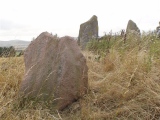
The site consists of several stony cairns that occupy a natural shelf on an otherwise northerly slope. The featured cairns in this post lie in close proximity to each other. range form 6m to 5m in diameter and their height ranges from 0.25m and 0.40m. All of these cairns lie to the east of a boundary fence that separates the open moor from the forestry to the west. They may be ancient field clearances but there's evidence of nearby prehistoric activity and some scheduled monuments that may be contemporary.
Another interesting site within a very scenic environment that overlooks the Mawddach Estuary and southern Eryri.
You may be viewing yesterday's version of this page. To see the most up to date information please register for a free account.
")
")
")
")
")
")
")
Do not use the above information on other web sites or publications without permission of the contributor.
Click here to see more info for this site
Nearby sites
Key: Red: member's photo, Blue: 3rd party photo, Yellow: other image, Green: no photo - please go there and take one, Grey: site destroyed
Download sites to:
KML (Google Earth)
GPX (GPS waypoints)
CSV (Garmin/Navman)
CSV (Excel)
To unlock full downloads you need to sign up as a Contributory Member. Otherwise downloads are limited to 50 sites.
Turn off the page maps and other distractions
Nearby sites listing. In the following links * = Image available
145m NW 318° Braich Ddu Round Hut* Ancient Village or Settlement (SH6352512130)
152m NW 309° Braich Ddu Cairns* Cairn (SH6350512120)
312m NW 319° Cyfannedd Fawr Settlement* Ancient Village or Settlement (SH6342012260)
424m SW 225° Settlement and Cairn South of Cyfannedd Fawr* Ancient Village or Settlement (SH6331011730)
566m SSW 197° Bedd-y-brenin* Cairn (SH6343811484)
616m SW 219° Cyfannedd Fawr erratic* Natural Stone / Erratic / Other Natural Feature (SH63221155)
651m SW 227° Hut Circle Settlement SE of Cyfannedd Fawr* Ancient Village or Settlement (SH6313011590)
675m NNW 333° Bron-Llety-Ifan* Rock Art (SH63331263)
1.0km WSW 256° Bryn Seward Cairn East* Cairn (SH626118)
1.1km WSW 252° Bryn Seward Cairn 1* Cairn (SH6259711729)
1.1km WSW 254° Bryn Seward Stone Row* Stone Row / Alignment (SH6258811760)
1.1km WSW 251° Bryn Seward Hut Circle* Ancient Village or Settlement (SH6256411688)
1.2km WSW 254° Bryn Seward Cairn 7* Cairn (SH6249011722)
1.2km WSW 256° Bryn Seward Cairn 2* Cairn (SH6246011770)
1.2km WSW 253° Bryn Seward Cairn 6* Cairn (SH6247211700)
1.2km SW 219° Pen y Garn Cairn and Cist* Cairn (SH6284911112)
1.2km WSW 255° Bryn Seward Cairn 5* Cairn (SH6245911744)
1.2km WSW 242° Bryn Seward Round House and Field System* Ancient Village or Settlement (SH6254111493)
1.2km WSW 249° Bryn Seward Cairn 3* Cairn (SH6244811614)
1.3km WSW 253° Bryn Seward Cairn 4* Cairn (SH6240711687)
1.3km WSW 257° Bryn Seward Cairn Cemetery* Barrow Cemetery (SH6233011770)
1.3km WSW 257° Bryn Seward Probable Cairn* Cairn (SH6231011750)
1.3km W 259° Bryn Seward Settlement* Ancient Village or Settlement (SH623118)
1.5km WSW 252° Cairn West of Bryn Seward* Cairn (SH622116)
1.8km WSW 248° Waun-Oer tomb* Chambered Tomb (SH6192711394)
View more nearby sites and additional images


 We would like to know more about this location. Please feel free to add a brief description and any relevant information in your own language.
 Wir möchten mehr über diese Stätte erfahren. Bitte zögern Sie nicht, eine kurze Beschreibung und relevante Informationen in Deutsch hinzuzufügen.
 Nous aimerions en savoir encore un peu sur les lieux. S'il vous plaît n'hesitez pas à ajouter une courte description et tous les renseignements pertinents dans votre propre langue.
 Quisieramos informarnos un poco más de las lugares. No dude en añadir una breve descripción y otros datos relevantes en su propio idioma.