<< Our Photo Pages >> Braich Ddu Round Hut - Ancient Village or Settlement in Wales in Gwynedd
Submitted by TAlanJones on Monday, 06 May 2024 Page Views: 30
Multi-periodSite Name: Braich Ddu Round Hut Alternative Name: Unenclosed Hut Circle, CyfanneddCountry: Wales County: Gwynedd Type: Ancient Village or Settlement
Nearest Town: Llwyngwril Nearest Village: Friog
Map Ref: SH6352512130
Latitude: 52.689611N Longitude: 4.020628W
Condition:
| 5 | Perfect |
| 4 | Almost Perfect |
| 3 | Reasonable but with some damage |
| 2 | Ruined but still recognisable as an ancient site |
| 1 | Pretty much destroyed, possibly visible as crop marks |
| 0 | No data. |
| -1 | Completely destroyed |
| 5 | Superb |
| 4 | Good |
| 3 | Ordinary |
| 2 | Not Good |
| 1 | Awful |
| 0 | No data. |
| 5 | Can be driven to, probably with disabled access |
| 4 | Short walk on a footpath |
| 3 | Requiring a bit more of a walk |
| 2 | A long walk |
| 1 | In the middle of nowhere, a nightmare to find |
| 0 | No data. |
| 5 | co-ordinates taken by GPS or official recorded co-ordinates |
| 4 | co-ordinates scaled from a detailed map |
| 3 | co-ordinates scaled from a bad map |
| 2 | co-ordinates of the nearest village |
| 1 | co-ordinates of the nearest town |
| 0 | no data |
Internal Links:
External Links:
")
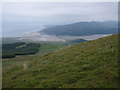
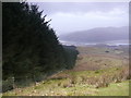
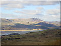
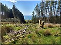
Situated in the uplands above Friog the area can be driven to via the lane that leads from Llwyngwril to Dolgellau. This is a scheduled site that occupies a natural shelf on the northern slope of Braich Ddu. The hut circle lies either side of a boundary fence that separates the open moor to the east from the forestry to the west. Coflein has recorded the site as NPRN 302835.
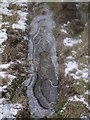
The hut circle has a fragmented dry stone bank that's more prominent on its western side. I paced the diameter to be 8m and its height to be less than a metre which almost agrees with the scheduled monuments account. Coflein do not provide a description but Gwynedd Archaeological Trust's Archwilio site does. Both descriptions emphasise a difficulty to interpret the site. However, the scheduled monument interpretation differs to that of Archwilio in that they state that the monument could be a ring cairn dating from the Bronze Age as opposed to a later round house? The scheduled monuments description of the site also mentions the two cairns lying a little further west, that I have visited but a cairn field to the south does not get a mention.
An interesting site within a very scenic environment spoilt only by the numbers of 4x4 off-roaders noisily travelling along the ancient trackways.
You may be viewing yesterday's version of this page. To see the most up to date information please register for a free account.
")
")
")
")
Do not use the above information on other web sites or publications without permission of the contributor.
Nearby Images from Geograph Britain and Ireland:
©2008(licence)
©2014(licence)
©2007(licence)
©2013(licence)
©2019(licence)
The above images may not be of the site on this page, they are loaded from Geograph.
Please Submit an Image of this site or go out and take one for us!
Click here to see more info for this site
Nearby sites
Key: Red: member's photo, Blue: 3rd party photo, Yellow: other image, Green: no photo - please go there and take one, Grey: site destroyed
Download sites to:
KML (Google Earth)
GPX (GPS waypoints)
CSV (Garmin/Navman)
CSV (Excel)
To unlock full downloads you need to sign up as a Contributory Member. Otherwise downloads are limited to 50 sites.
Turn off the page maps and other distractions
Nearby sites listing. In the following links * = Image available
22m WSW 242° Braich Ddu Cairns* Cairn (SH6350512120)
145m SE 138° Braich Ddu Cairn Cemetery* Barrow Cemetery (SH6362012020)
167m NW 320° Cyfannedd Fawr Settlement* Ancient Village or Settlement (SH6342012260)
454m SSW 207° Settlement and Cairn South of Cyfannedd Fawr* Ancient Village or Settlement (SH6331011730)
536m NNW 337° Bron-Llety-Ifan* Rock Art (SH63331263)
651m S 186° Bedd-y-brenin* Cairn (SH6343811484)
655m SSW 206° Cyfannedd Fawr erratic* Natural Stone / Erratic / Other Natural Feature (SH63221155)
668m SW 215° Hut Circle Settlement SE of Cyfannedd Fawr* Ancient Village or Settlement (SH6313011590)
979m WSW 249° Bryn Seward Cairn East* Cairn (SH626118)
1.0km WSW 247° Bryn Seward Stone Row* Stone Row / Alignment (SH6258811760)
1.0km WSW 245° Bryn Seward Cairn 1* Cairn (SH6259711729)
1.1km WSW 244° Bryn Seward Hut Circle* Ancient Village or Settlement (SH6256411688)
1.1km WSW 247° Bryn Seward Cairn 7* Cairn (SH6249011722)
1.1km WSW 250° Bryn Seward Cairn 2* Cairn (SH6246011770)
1.1km WSW 248° Bryn Seward Cairn 5* Cairn (SH6245911744)
1.1km WSW 246° Bryn Seward Cairn 6* Cairn (SH6247211700)
1.2km SW 235° Bryn Seward Round House and Field System* Ancient Village or Settlement (SH6254111493)
1.2km WSW 243° Bryn Seward Cairn 3* Cairn (SH6244811614)
1.2km WSW 247° Bryn Seward Cairn 4* Cairn (SH6240711687)
1.2km SSW 212° Pen y Garn Cairn and Cist* Cairn (SH6284911112)
1.2km WSW 252° Bryn Seward Cairn Cemetery* Barrow Cemetery (SH6233011770)
1.3km WSW 253° Bryn Seward Settlement* Ancient Village or Settlement (SH623118)
1.3km WSW 251° Bryn Seward Probable Cairn* Cairn (SH6231011750)
1.4km WSW 247° Cairn West of Bryn Seward* Cairn (SH622116)
2.0km WSW 243° Waun Oer* Stone Row / Alignment (SH61741128)
View more nearby sites and additional images


 We would like to know more about this location. Please feel free to add a brief description and any relevant information in your own language.
 Wir möchten mehr über diese Stätte erfahren. Bitte zögern Sie nicht, eine kurze Beschreibung und relevante Informationen in Deutsch hinzuzufügen.
 Nous aimerions en savoir encore un peu sur les lieux. S'il vous plaît n'hesitez pas à ajouter une courte description et tous les renseignements pertinents dans votre propre langue.
 Quisieramos informarnos un poco más de las lugares. No dude en añadir una breve descripción y otros datos relevantes en su propio idioma.