

<< Text Pages >> Kinloch Lodge Carved Stone - Sculptured Stone in Scotland in Sutherland
Submitted by h_fenton on Monday, 13 February 2012 Page Views: 4006
Multi-periodSite Name: Kinloch Lodge Carved Stone Alternative Name: Lochan HakelCountry: Scotland County: Sutherland Type: Sculptured Stone
Nearest Village: Tongue
Map Ref: NC5620952749
Latitude: 58.439305N Longitude: 4.464844W
Condition:
| 5 | Perfect |
| 4 | Almost Perfect |
| 3 | Reasonable but with some damage |
| 2 | Ruined but still recognisable as an ancient site |
| 1 | Pretty much destroyed, possibly visible as crop marks |
| 0 | No data. |
| -1 | Completely destroyed |
| 5 | Superb |
| 4 | Good |
| 3 | Ordinary |
| 2 | Not Good |
| 1 | Awful |
| 0 | No data. |
| 5 | Can be driven to, probably with disabled access |
| 4 | Short walk on a footpath |
| 3 | Requiring a bit more of a walk |
| 2 | A long walk |
| 1 | In the middle of nowhere, a nightmare to find |
| 0 | No data. |
| 5 | co-ordinates taken by GPS or official recorded co-ordinates |
| 4 | co-ordinates scaled from a detailed map |
| 3 | co-ordinates scaled from a bad map |
| 2 | co-ordinates of the nearest village |
| 1 | co-ordinates of the nearest town |
| 0 | no data |
Be the first person to rate this site - see the 'Contribute!' box in the right hand menu.
Internal Links:
External Links:
Sculptured Stone in Sutherland
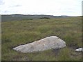
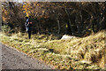
A 1.9m long stone lying in the ground. There are linear and curvilinear lines incised into the rock - these marks are considered to be man-made but do not conform to any known Early Christian or Pictish symbols nor do they form any other recognisable pattern.
Canmore: http://canmore.rcahms.gov.uk/en/site/5367/details/kinloch+lodge/
Google Street View: http://maps.google.co.uk/?ll=58.439293,-4.464698&spn=0.00104,0.003396&t=h&z=19&layer=c&cbll=58.439293,-4.464698&panoid=QEXKfMMLXCnKTQxTjj2WNA&cbp=12,299.61,,0,12.01
You may be viewing yesterday's version of this page. To see the most up to date information please register for a free account.
Do not use the above information on other web sites or publications without permission of the contributor.
Nearby Images from Geograph Britain and Ireland:
©2007(licence)
©2020(licence)
©2020(licence)
©2020(licence)
©2021(licence)
The above images may not be of the site on this page, they are loaded from Geograph.
Please Submit an Image of this site or go out and take one for us!
Click here to see more info for this site
Nearby sites
Key: Red: member's photo, Blue: 3rd party photo, Yellow: other image, Green: no photo - please go there and take one, Grey: site destroyed
Download sites to:
KML (Google Earth)
GPX (GPS waypoints)
CSV (Garmin/Navman)
CSV (Excel)
To unlock full downloads you need to sign up as a Contributory Member. Otherwise downloads are limited to 50 sites.
Turn off the page maps and other distractions
Nearby sites listing. In the following links * = Image available
43m SSW 191° Kinloch Cup marked Stone* Rock Art (NC5619952707)
730m E 98° Grianan Cup and Ring marked Stone Rock Art (NC56935262)
1.0km WNW 284° Dun Mhaigh* Broch or Nuraghe (NC55225303)
1.2km W 262° Kinloch Chambered Cairn Chambered Cairn (NC54975262)
8.4km NE 42° Dallcharn Broch or Nuraghe (NC62105875)
9.6km WNW 288° Creagan na Speireig Cairn (NC47205603)
9.8km NNE 31° Scullomie Broch or Nuraghe (NC615610)
10.2km WNW 297° Lochside Cairn Cairn (NC47265772)
10.7km WNW 298° Arnaboll Cairn Cairn (NC46875806)
11.1km WNW 302° Arnaboll Hut Circle (1) Cairn (NC46915893)
11.2km WNW 302° Arnaboll Hut Circle (2) Cairn (NC46895903)
11.2km N 359° West Strathan* Broch or Nuraghe (NC56456401)
11.3km N 359° West Strathan Carving (Melness) Rock Art (NC5642864084)
11.6km ENE 57° Borgie Stone Rows* Multiple Stone Rows / Avenue (NC66135874)
12.0km NW 310° Weirs Hut Circle (1) Cairn (NC47276079)
12.2km NW 311° Weirs Hut Circle (2) Cairn (NC47236104)
12.7km WNW 292° Camus An Duin Broch or Nuraghe (NC44595797)
12.7km NW 304° Heilam Hut Circle (1) Cairn (NC45916026)
12.8km NW 304° Heilam Hut Circle (2) Cairn (NC45896036)
12.8km NW 305° Heilam Broch* Broch or Nuraghe (NC46026056)
12.9km NW 305° Heilam Hut Circle (3) Cairn (NC45876052)
13.0km SW 231° Dun Dornaigil* Broch or Nuraghe (NC457450)
13.1km ENE 58° Borgie Souterrain* Souterrain (Fogou, Earth House) (NC67625929)
13.2km WNW 303° Heilam Hut Circle (4) Cairn (NC45426042)
13.5km WNW 299° Dun Neachdie Broch or Nuraghe (NC446597)
View more nearby sites and additional images


 We would like to know more about this location. Please feel free to add a brief description and any relevant information in your own language.
 Wir möchten mehr über diese Stätte erfahren. Bitte zögern Sie nicht, eine kurze Beschreibung und relevante Informationen in Deutsch hinzuzufügen.
 Nous aimerions en savoir encore un peu sur les lieux. S'il vous plaît n'hesitez pas à ajouter une courte description et tous les renseignements pertinents dans votre propre langue.
 Quisieramos informarnos un poco más de las lugares. No dude en añadir una breve descripción y otros datos relevantes en su propio idioma.