


<< Text Pages >> Spreacombe Fort - Hillfort in England in Devon
Submitted by Bladup on Saturday, 08 November 2025 Page Views: 704
Iron Age and Later PrehistorySite Name: Spreacombe FortCountry: England
NOTE: This site is 1.5 km away from the location you searched for.
County: Devon Type: Hillfort
Map Ref: SS4823641585
Latitude: 51.153342N Longitude: 4.171404W
Condition:
| 5 | Perfect |
| 4 | Almost Perfect |
| 3 | Reasonable but with some damage |
| 2 | Ruined but still recognisable as an ancient site |
| 1 | Pretty much destroyed, possibly visible as crop marks |
| 0 | No data. |
| -1 | Completely destroyed |
| 5 | Superb |
| 4 | Good |
| 3 | Ordinary |
| 2 | Not Good |
| 1 | Awful |
| 0 | No data. |
| 5 | Can be driven to, probably with disabled access |
| 4 | Short walk on a footpath |
| 3 | Requiring a bit more of a walk |
| 2 | A long walk |
| 1 | In the middle of nowhere, a nightmare to find |
| 0 | No data. |
| 5 | co-ordinates taken by GPS or official recorded co-ordinates |
| 4 | co-ordinates scaled from a detailed map |
| 3 | co-ordinates scaled from a bad map |
| 2 | co-ordinates of the nearest village |
| 1 | co-ordinates of the nearest town |
| 0 | no data |
Internal Links:
External Links:
Hillfort in Devon
Spreacombe Fort ia an irregular circular earthwork situated on eastern end of a ridge whose slopes are not steep. Its defences consist of a ditch to east and south, where land falls away, and of a ditch with inner bank across north and west where the land is almost level. The south and east portion which falls in a wood is fairly well preserved while the remainder which lies in pasture land, has been under plough and is ploughed out. No definite trace of an entrance nor of hut circles in interior. A water supply is available immediately to south.
You may be viewing yesterday's version of this page. To see the most up to date information please register for a free account.
")
Do not use the above information on other web sites or publications without permission of the contributor.
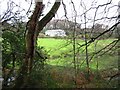
Nearby Images from Geograph Britain and Ireland:

©2010(licence)

©2010(licence)

©2010(licence)
©2012(licence)

©2012(licence)
The above images may not be of the site on this page, they are loaded from Geograph.
Please Submit an Image of this site or go out and take one for us!
Click here to see more info for this site
Nearby sites
Key: Red: member's photo, Blue: 3rd party photo, Yellow: other image, Green: no photo - please go there and take one, Grey: site destroyed
Download sites to:
KML (Google Earth)
GPX (GPS waypoints)
CSV (Garmin/Navman)
CSV (Excel)
To unlock full downloads you need to sign up as a Contributory Member. Otherwise downloads are limited to 50 sites.
Turn off the page maps and other distractions
Nearby sites listing. In the following links * = Image available
3.3km SSE 169° Knowle Castle* Hillfort (SS488383)
3.4km NW 325° Greystone* Standing Stone (Menhir) (SS46354443)
3.5km NW 323° The Konk Stone* Standing Stone (Menhir) (SS4620044400)
3.6km NW 308° Woolacombe Memorial* Modern Stone Circle etc (SS45494389)
4.2km S 172° St. Brannoc's Holy Well (Braunton)* Holy Well or Sacred Spring (SS487374)
4.6km NNW 328° North Morte Well* Holy Well or Sacred Spring (SS459455)
4.6km SW 234° St Helen's Well (Croyde)* Holy Well or Sacred Spring (SS4440538970)
4.7km NNW 344° Damage Barton* Standing Stones (SS47044615)
4.7km NNE 15° Whitestone (Lee)* Standing Stone (Menhir) (SS49564613)
4.7km WSW 258° Baggy Point erratic* Natural Stone / Erratic / Other Natural Feature (SS4356540705)
4.9km NNW 344° Damage Barton 2* Standing Stone (Menhir) (SS47064633)
5.0km NNW 346° Damage Barton 3* Standing Stone (Menhir) (SS47194647)
6.1km ENE 78° Centery Farm Tumuli* Barrow Cemetery (SS543427)
7.9km NE 37° Hillsborough* Hillfort (SS532477)
8.7km S 172° Yelland* Multiple Stone Rows / Avenue (SS4912532889)
8.9km ENE 75° Berry Down Barrows* Barrow Cemetery (SS5690043600)
10.2km ESE 107° Plaistow Enclosure* Ancient Village or Settlement (SS5793038350)
10.2km SE 135° Pilton Long Stone* Standing Stone (Menhir) (SS55313421)
10.4km SE 133° Ladywell (Pilton)* Holy Well or Sacred Spring (SS556342)
10.5km ENE 57° Newberry Camp Hillfort (SS57164708)
10.7km SE 125° Burridge Camp* Ancient Village or Settlement (SS569352)
10.9km ENE 76° Mattocks Down Barrow* Long Barrow (SS589439)
10.9km SE 143° Dripping Well (Barnstaple)* Holy Well or Sacred Spring (SS546327)
11.5km SE 137° Museum of Barnstaple and North Devon* Museum (SS5586732983)
12.0km ENE 77° Mattocks Down Stone Row Stone Row / Alignment (SS6004643921)
View more nearby sites and additional images


 We would like to know more about this location. Please feel free to add a brief description and any relevant information in your own language.
 Wir möchten mehr über diese Stätte erfahren. Bitte zögern Sie nicht, eine kurze Beschreibung und relevante Informationen in Deutsch hinzuzufügen.
 Nous aimerions en savoir encore un peu sur les lieux. S'il vous plaît n'hesitez pas à ajouter une courte description et tous les renseignements pertinents dans votre propre langue.
 Quisieramos informarnos un poco más de las lugares. No dude en añadir una breve descripción y otros datos relevantes en su propio idioma.