<< Our Photo Pages >> Cnoc Udais Cairn - Cairn in Scotland in Highlands
Submitted by PeteCrane5 on Wednesday, 01 May 2024 Page Views: 412
Neolithic and Bronze AgeSite Name: Cnoc Udais CairnCountry: Scotland County: Highlands Type: Cairn
Nearest Town: Inverness Nearest Village: Muir of Ord
Map Ref: NH48154984
Latitude: 57.513197N Longitude: 4.536598W
Condition:
| 5 | Perfect |
| 4 | Almost Perfect |
| 3 | Reasonable but with some damage |
| 2 | Ruined but still recognisable as an ancient site |
| 1 | Pretty much destroyed, possibly visible as crop marks |
| 0 | No data. |
| -1 | Completely destroyed |
| 5 | Superb |
| 4 | Good |
| 3 | Ordinary |
| 2 | Not Good |
| 1 | Awful |
| 0 | No data. |
| 5 | Can be driven to, probably with disabled access |
| 4 | Short walk on a footpath |
| 3 | Requiring a bit more of a walk |
| 2 | A long walk |
| 1 | In the middle of nowhere, a nightmare to find |
| 0 | No data. |
| 5 | co-ordinates taken by GPS or official recorded co-ordinates |
| 4 | co-ordinates scaled from a detailed map |
| 3 | co-ordinates scaled from a bad map |
| 2 | co-ordinates of the nearest village |
| 1 | co-ordinates of the nearest town |
| 0 | no data |
Internal Links:
External Links:
")
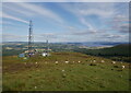
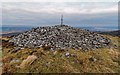
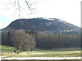
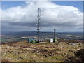
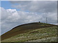
This large cairn, of unknown age, is conspicuously situated on the summit of Cnoc Udais. It is a cairn of bare rubble stones measuring c.15.0m in diameter and c.1.5, in height now 'sharing' the hill with three telephone masts.
You may be viewing yesterday's version of this page. To see the most up to date information please register for a free account.
Do not use the above information on other web sites or publications without permission of the contributor.
Nearby Images from Geograph Britain and Ireland:
©2021(licence)
©2017(licence)
©2006(licence)
©2006(licence)
©2006(licence)
The above images may not be of the site on this page, they are loaded from Geograph.
Please Submit an Image of this site or go out and take one for us!
Click here to see more info for this site
Nearby sites
Key: Red: member's photo, Blue: 3rd party photo, Yellow: other image, Green: no photo - please go there and take one, Grey: site destroyed
Download sites to:
KML (Google Earth)
GPX (GPS waypoints)
CSV (Garmin/Navman)
CSV (Excel)
To unlock full downloads you need to sign up as a Contributory Member. Otherwise downloads are limited to 50 sites.
Turn off the page maps and other distractions
Nearby sites listing. In the following links * = Image available
4.5km E 90° Muir of Ord Henge* Henge (NH527497)
5.2km ESE 106° Windhill* Standing Stones (NH531482)
5.7km SSE 157° Ballblair Wood Chambered Cairn (NH502445)
5.8km NNE 21° Brahan Wood* Chambered Cairn (NH504552)
6.1km ENE 68° Balvaird Chambered Cairn (NH53945193)
6.3km NNW 339° Preas Mairi* Chambered Cairn (NH46095584)
6.6km ENE 62° Bishop Kinkell Chambered Cairn (NH541527)
6.7km N 3° Ballachnecore* Chambered Cairn (NH488565)
6.7km E 89° Tarradale* Chambered Tomb (NH549497)
6.9km ENE 66° Muir of Conan Chambered Cairn (NH546524)
7.4km ENE 66° Muir of Allangrange* Chambered Cairn (NH55005259)
8.0km NE 47° Conon Bridge* Henge (NH54295507)
8.1km S 171° Culburnie* Stone Circle (NH491418)
8.1km SSE 167° Beaufort Cottages Cairn* Cairn (NH49654188)
8.2km NE 34° Ussie Chambered Cairn* Chambered Cairn (NH530565)
8.3km ENE 69° Cairnside Chambered Tomb (NH560525)
8.4km SSE 155° Belladrum Chambered Cairn* Chambered Cairn (NH5141742120)
8.6km SSE 166° Bruiach* Cairn (NH49984143)
8.7km N 360° Strathpeffer* Class I Pictish Symbol Stone (NH48455852)
8.8km ENE 72° Carn Urnan* Stone Circle (NH5666252289)
8.9km SSE 155° Belladrum South Chambered Tomb (NH5161041578)
9.0km NNE 13° Knock Farril* Vitrified Fort (NH505585)
9.0km ENE 77° Kilcoy South* Chambered Tomb (NH570515)
9.0km ENE 76° Kilcoy North Chambered Tomb (NH570517)
9.3km SSE 156° Meg's Stone* Standing Stone (Menhir) (NH5164541196)
View more nearby sites and additional images


 We would like to know more about this location. Please feel free to add a brief description and any relevant information in your own language.
 Wir möchten mehr über diese Stätte erfahren. Bitte zögern Sie nicht, eine kurze Beschreibung und relevante Informationen in Deutsch hinzuzufügen.
 Nous aimerions en savoir encore un peu sur les lieux. S'il vous plaît n'hesitez pas à ajouter une courte description et tous les renseignements pertinents dans votre propre langue.
 Quisieramos informarnos un poco más de las lugares. No dude en añadir una breve descripción y otros datos relevantes en su propio idioma.