

<< Our Photo Pages >> Carn Urnan - Stone Circle in Scotland in Highlands
Submitted by MattChapman on Sunday, 15 October 2023 Page Views: 12708
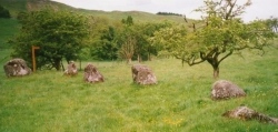
Neolithic and Bronze AgeSite Name: Carn Urnan Alternative Name: Carn Inenan, Cairn IrenanCountry: Scotland County: Highlands Type: Stone Circle
Nearest Town: Dingwall Nearest Village: Muir of Ord
Map Ref: NH5666252289 Landranger Map Number: 26
Latitude: 57.537951N Longitude: 4.396088W
Condition:
| 5 | Perfect |
| 4 | Almost Perfect |
| 3 | Reasonable but with some damage |
| 2 | Ruined but still recognisable as an ancient site |
| 1 | Pretty much destroyed, possibly visible as crop marks |
| 0 | No data. |
| -1 | Completely destroyed |
| 5 | Superb |
| 4 | Good |
| 3 | Ordinary |
| 2 | Not Good |
| 1 | Awful |
| 0 | No data. |
| 5 | Can be driven to, probably with disabled access |
| 4 | Short walk on a footpath |
| 3 | Requiring a bit more of a walk |
| 2 | A long walk |
| 1 | In the middle of nowhere, a nightmare to find |
| 0 | No data. |
| 5 | co-ordinates taken by GPS or official recorded co-ordinates |
| 4 | co-ordinates scaled from a detailed map |
| 3 | co-ordinates scaled from a bad map |
| 2 | co-ordinates of the nearest village |
| 1 | co-ordinates of the nearest town |
| 0 | no data |
Internal Links:
External Links:
I have visited· I would like to visit
lichen would like to visit
soulsurfer visited on 3rd Sep 2013 - their rating: Cond: 3 Amb: 4 Access: 4 Access via the farm track is very easy. The croft house is currently unused (Sept 2013).
PeteCrane5 have visited here
")
Of the kerb cairn itself most of the cairn material has been removed leaving only the outer kerb stones and the passage (facing south-south-west)and chamber walls. Many of the stones are overgrown with grass. Immediately outside the entrance is another stone which may have been a lintel.
References
The Chambered Cairns of the Central Highlands, A.S.Henshall & J.N.G.Ritchie (Edinburgh Uni Press, 2001).
Page originally by Vicky.
You may be viewing yesterday's version of this page. To see the most up to date information please register for a free account.
")
")
")
")
")
")
")
")
")
")
")
")
")
")
Do not use the above information on other web sites or publications without permission of the contributor.
Click here to see more info for this site
Nearby sites
Key: Red: member's photo, Blue: 3rd party photo, Yellow: other image, Green: no photo - please go there and take one, Grey: site destroyed
Download sites to:
KML (Google Earth)
GPX (GPS waypoints)
CSV (Garmin/Navman)
CSV (Excel)
To unlock full downloads you need to sign up as a Contributory Member. Otherwise downloads are limited to 50 sites.
Turn off the page maps and other distractions
Nearby sites listing. In the following links * = Image available
678m SSE 148° Kilcoy North Chambered Tomb (NH570517)
693m WNW 286° Cairnside Chambered Tomb (NH560525)
857m SSE 155° Kilcoy South* Chambered Tomb (NH570515)
1.1km ESE 108° Mains of Kilcoy NW* Cairn (NH57725191)
1.2km ESE 102° Carn Glas* Chambered Cairn (NH578520)
1.2km ESE 109° Mains of Kilcoy SE* Cairn (NH57765186)
1.7km W 278° Muir of Allangrange* Chambered Cairn (NH55005259)
2.1km W 271° Muir of Conan Chambered Cairn (NH546524)
2.6km W 277° Bishop Kinkell Chambered Cairn (NH541527)
2.7km W 260° Balvaird Chambered Cairn (NH53945193)
3.1km SSW 212° Tarradale* Chambered Tomb (NH549497)
3.6km NW 318° Conon Bridge* Henge (NH54295507)
4.6km N 10° Mulchaich* Cairn (NH57665679)
4.7km SW 235° Muir of Ord Henge* Henge (NH527497)
5.1km E 84° The Temple (Tore)* Chambered Tomb (NH6179952610)
5.4km SW 219° Windhill* Standing Stones (NH531482)
5.6km NW 317° Ussie Chambered Cairn* Chambered Cairn (NH530565)
6.6km ENE 66° Balnaguie* Chambered Cairn (NH62835473)
6.9km NNW 343° Dingwall* Class I Pictish Symbol Stone (NH54935893)
6.9km WNW 293° Brahan Wood* Chambered Cairn (NH504552)
7.5km ENE 77° Cloutie Well* Holy Well or Sacred Spring (NH641537)
8.6km ENE 63° Belmaduthy* Chambered Cairn (NH6447255983)
8.6km S 183° Giant's Grave (Highlands) Chambered Cairn (NH55904369)
8.7km NW 313° Knock Farril* Vitrified Fort (NH505585)
8.8km WSW 252° Cnoc Udais Cairn* Cairn (NH48154984)
View more nearby sites and additional images


 We would like to know more about this location. Please feel free to add a brief description and any relevant information in your own language.
 Wir möchten mehr über diese Stätte erfahren. Bitte zögern Sie nicht, eine kurze Beschreibung und relevante Informationen in Deutsch hinzuzufügen.
 Nous aimerions en savoir encore un peu sur les lieux. S'il vous plaît n'hesitez pas à ajouter une courte description et tous les renseignements pertinents dans votre propre langue.
 Quisieramos informarnos un poco más de las lugares. No dude en añadir una breve descripción y otros datos relevantes en su propio idioma.