

<< Our Photo Pages >> Propped stones on Garrow Tor - Natural Stone / Erratic / Other Natural Feature in England in Cornwall
Submitted by DaveQuoroll on Thursday, 16 July 2020 Page Views: 894
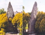
Natural PlacesSite Name: Propped stones on Garrow TorCountry: England County: Cornwall Type: Natural Stone / Erratic / Other Natural Feature
Nearest Town: Bodmin Nearest Village: St Breward
Map Ref: SX145784
Latitude: 50.575811N Longitude: 4.621239W
Condition:
| 5 | Perfect |
| 4 | Almost Perfect |
| 3 | Reasonable but with some damage |
| 2 | Ruined but still recognisable as an ancient site |
| 1 | Pretty much destroyed, possibly visible as crop marks |
| 0 | No data. |
| -1 | Completely destroyed |
| 5 | Superb |
| 4 | Good |
| 3 | Ordinary |
| 2 | Not Good |
| 1 | Awful |
| 0 | No data. |
| 5 | Can be driven to, probably with disabled access |
| 4 | Short walk on a footpath |
| 3 | Requiring a bit more of a walk |
| 2 | A long walk |
| 1 | In the middle of nowhere, a nightmare to find |
| 0 | No data. |
| 5 | co-ordinates taken by GPS or official recorded co-ordinates |
| 4 | co-ordinates scaled from a detailed map |
| 3 | co-ordinates scaled from a bad map |
| 2 | co-ordinates of the nearest village |
| 1 | co-ordinates of the nearest town |
| 0 | no data |
Internal Links:
External Links:
")
Propped stones are described by David Shepherd in 'The Old Stones' and some have been recorded in Cornwall. Usually these are found singly on or near the tops of Granite tors on Bodmin Moor. They can be difficult to distinguish from naturally eroded features, although some can only be explained by human intervention as the orientation of the stones is clearly different from those beneath and they are propped in place by stones of a different type to the rest of the feature.
The area between the ancient settlement and the top of Garrow Tor has an extremely unusual density of these features with at least three certain and more than a dozen potential propped stones. I have personally visited most Cornish hill tops and many on Dartmoor and have never anything anything like this number of altered stones.
The age and purpose of propped stones is unknown but it would be reasonable to assume a link with the nearby Bronze Age settlement as the density of human occupation in this area would have declined after this period and it would have taken considerable input of effort to move these stones. The orientation and shapes of the stones varies considerably which might indicate that they do not have a particular religious or astronomical purpose.
You may be viewing yesterday's version of this page. To see the most up to date information please register for a free account.
")
")
")
")
")
")
")
")
")
")
")
")
")
")
")
")
")
Do not use the above information on other web sites or publications without permission of the contributor.
Click here to see more info for this site
Nearby sites
Key: Red: member's photo, Blue: 3rd party photo, Yellow: other image, Green: no photo - please go there and take one, Grey: site destroyed
Download sites to:
KML (Google Earth)
GPX (GPS waypoints)
CSV (Garmin/Navman)
CSV (Excel)
To unlock full downloads you need to sign up as a Contributory Member. Otherwise downloads are limited to 50 sites.
Turn off the page maps and other distractions
Nearby sites listing. In the following links * = Image available
400m S 178° Garrow Tor* Ancient Village or Settlement (SX145780)
649m NNW 348° Fernacre Cairn 1* Cairn (SX14397904)
910m N 0° Fernacre Cairn 2 Cairn (SX14547931)
1.0km N 4° Fernacre Cairn 3 Cairn (SX14607942)
1.1km SSE 151° Butterstor Ancient Village or Settlement (SX150774)
1.2km NE 34° Fernacre Settlement 2 Ancient Village or Settlement (SX15227938)
1.2km SW 221° Emblance Down stone row* Stone Row / Alignment (SX13677750)
1.3km SSW 214° Leaze cairn* Cairn (SX13737733)
1.4km SW 226° King Arthur's Down SE* Stone Circle (SX13497750)
1.4km SW 227° King Arthur's Down NW* Stone Circle (SX13477751)
1.4km SW 215° Leaze stone circle* Stone Circle (SX13677729)
1.5km NNW 333° Louden Hill Cists* Cairn (SX13877976)
1.5km NNW 333° Louden Hill Cairn 2* Cairn (SX13867976)
1.5km NNW 330° Louden 2* Cairn (SX13797975)
1.6km NNW 327° Louden menhirs* Standing Stones (SX13707974)
1.6km NNE 14° Fernacre Settlement 1* Ancient Village or Settlement (SX14937990)
1.6km N 357° Fernacre* Stone Circle (SX14477998)
1.6km N 360° Fernacre Outlier* Standing Stone (Menhir) (SX14557998)
1.6km NW 321° Louden 1* Cairn (SX13547968)
1.6km NNW 328° Louden south* Ancient Village or Settlement (SX137798)
1.6km NW 320° Louden Hill Cairn* Cairn (SX13507967)
1.7km NW 309° Louden Hill circle* Stone Circle (SX13217950)
1.7km NW 320° Louden Hill 3* Cairn (SX13467974)
1.7km WSW 241° King Arthur's Hall* Standing Stones (SX12977764)
1.7km NW 311° Louden Hill Cairn x* Cairn (SX13257958)
View more nearby sites and additional images


 We would like to know more about this location. Please feel free to add a brief description and any relevant information in your own language.
 Wir möchten mehr über diese Stätte erfahren. Bitte zögern Sie nicht, eine kurze Beschreibung und relevante Informationen in Deutsch hinzuzufügen.
 Nous aimerions en savoir encore un peu sur les lieux. S'il vous plaît n'hesitez pas à ajouter une courte description et tous les renseignements pertinents dans votre propre langue.
 Quisieramos informarnos un poco más de las lugares. No dude en añadir una breve descripción y otros datos relevantes en su propio idioma.