

<< Our Photo Pages >> Emblance Down stone row - Stone Row / Alignment in England in Cornwall
Submitted by TheCaptain on Sunday, 27 March 2005 Page Views: 6662
Neolithic and Bronze AgeSite Name: Emblance Down stone row Alternative Name: previously here as King Arthur’s RowCountry: England County: Cornwall Type: Stone Row / Alignment
Nearest Town: Camelford Nearest Village: St Breward
Map Ref: SX13677750
Latitude: 50.567462N Longitude: 4.632497W
Condition:
| 5 | Perfect |
| 4 | Almost Perfect |
| 3 | Reasonable but with some damage |
| 2 | Ruined but still recognisable as an ancient site |
| 1 | Pretty much destroyed, possibly visible as crop marks |
| 0 | No data. |
| -1 | Completely destroyed |
| 5 | Superb |
| 4 | Good |
| 3 | Ordinary |
| 2 | Not Good |
| 1 | Awful |
| 0 | No data. |
| 5 | Can be driven to, probably with disabled access |
| 4 | Short walk on a footpath |
| 3 | Requiring a bit more of a walk |
| 2 | A long walk |
| 1 | In the middle of nowhere, a nightmare to find |
| 0 | No data. |
| 5 | co-ordinates taken by GPS or official recorded co-ordinates |
| 4 | co-ordinates scaled from a detailed map |
| 3 | co-ordinates scaled from a bad map |
| 2 | co-ordinates of the nearest village |
| 1 | co-ordinates of the nearest town |
| 0 | no data |
Internal Links:
External Links:
I have visited· I would like to visit
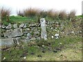
davep visited on 12th Jul 2022 - their rating: Amb: 3 Access: 3 I visited this location on Tuesday 12th July 2022. I concluded that the big stones near the wall are natural stones and not in my view artificially set. In line with these stones is a clear "reave" or bank creating an overall linear feature. This alignment is perpendicular to the current enclosure wall. The reave/bank may well be prehistoric and may well have deliberately incorporated these natural stones. In my view this is not a stone row.
See also:
https://www.heritagegateway.org.uk/Gateway/Results_Single.aspx?uid=MCO21647&resourceID=1020
LiveAndrew visited on 2nd Sep 2021 - their rating: Cond: 3 Amb: 4 Access: 3
TheCaptain have visited here
Average ratings for this site from all visit loggers: Ambience: 3.5 Access: 3
")
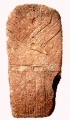
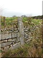
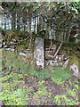
Walking eastwards from the two King Arthur's Down stone circles along the edge of the southern wall, and after a couple of hundred yards can be seen a large pointed stone flat to the ground. This stone is about three and a half metres long, and about a metre wide at the thicker end, which is adjacent to the wall. What I noticed that was odd about this stone, was the way that the wall seemed to have a little bump in it, and looked very like it had been built to detour around the stone, if it had been standing. It reminded me of the way the wall detours round the Gun Rith menhir, down near the Merry Maidens. It wouldn’t surprise me at all if this large stone had once been a large upright menhir.
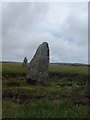
Looking around from here, and over the other side of the wall to the south could be seen another 4 large stones laying on the surface, which not only made a perfect line with the fallen wall stone, but also have an equal spacing of about 20 metres between them. Looking back to the north, and yes, there is a sixth stone to be seen in just the right position to have been part of a large stone row here.
I can find no reference to it on any maps, in Burl or on Defra, but then again, these are by no means conclusive. There are not many stone rows to be found in these parts, but only about 20 years ago it was thought there was only one stone row in Cornwall, and this number is now significantly more. If this was a row, it would not have been too different to the Nine Maidens on St Breock Down to the west.
You may be viewing yesterday's version of this page. To see the most up to date information please register for a free account.
")
")
Do not use the above information on other web sites or publications without permission of the contributor.
Nearby Images from Geograph Britain and Ireland:
©2005(licence)
©2021(licence)
©2021(licence)
©2021(licence)
©2021(licence)
The above images may not be of the site on this page, they are loaded from Geograph.
Please Submit an Image of this site or go out and take one for us!
Click here to see more info for this site
Nearby sites
Key: Red: member's photo, Blue: 3rd party photo, Yellow: other image, Green: no photo - please go there and take one, Grey: site destroyed
Download sites to:
KML (Google Earth)
GPX (GPS waypoints)
CSV (Garmin/Navman)
CSV (Excel)
To unlock full downloads you need to sign up as a Contributory Member. Otherwise downloads are limited to 50 sites.
![]()
Turn off the page maps and other distractions
Nearby sites listing. In the following links * = Image available
179m W 268° King Arthur's Down SE* Stone Circle (SX13497750)
180m SSE 159° Leaze cairn* Cairn (SX13737733)
200m W 271° King Arthur's Down NW* Stone Circle (SX13477751)
210m S 178° Leaze stone circle* Stone Circle (SX13677729)
704m SSW 210° Leaze Hut Circle* Ancient Village or Settlement (SX133769)
712m W 279° King Arthur's Hall* Standing Stones (SX12977764)
757m SW 227° Leaze Cist* Cist (SX131770)
873m W 277° King Arthur's Downs Cross* Ancient Cross (SX1280677643)
967m ENE 57° Garrow Tor* Ancient Village or Settlement (SX145780)
1.0km SSE 165° Carkees Tor* Ancient Village or Settlement (SX139765)
1.1km SW 215° Emblance Downs Hut Circle* Ancient Village or Settlement (SX130766)
1.1km WNW 291° Casehill Cairn* Cairn (SX12617794)
1.2km SW 235° Bolatherick* Standing Stone (Menhir) (SX12667684)
1.2km NE 41° Propped stones on Garrow Tor* Natural Stone / Erratic / Other Natural Feature (SX145784)
1.2km SSW 205° Clapper Bridge* Not Known (by us) (SX131764)
1.3km E 92° Butterstor Ancient Village or Settlement (SX150774)
1.4km SSW 193° Carkees Down Long House* Ancient Village or Settlement (SX133761)
1.5km SW 232° Whiteheads Standing Stone* Standing Stone (Menhir) (SX1241976611)
1.6km SW 230° Whiteheads Cist* Cist (SX12377649)
1.7km NNE 23° Fernacre Cairn 1* Cairn (SX14397904)
1.8km SW 227° Whiteheads Settlement Ancient Village or Settlement (SX123763)
1.8km SSW 206° Carbilly Farmstead Ancient Village or Settlement (SX128759)
2.0km NNE 24° Fernacre Cairn 2 Cairn (SX14547931)
2.1km NNW 345° Louden Hill circle* Stone Circle (SX13217950)
2.1km WNW 287° Treswallock Downs - Bronze Age cairn cemetery* Barrow Cemetery (SX11717816)
View more nearby sites and additional images


 We would like to know more about this location. Please feel free to add a brief description and any relevant information in your own language.
 Wir möchten mehr über diese Stätte erfahren. Bitte zögern Sie nicht, eine kurze Beschreibung und relevante Informationen in Deutsch hinzuzufügen.
 Nous aimerions en savoir encore un peu sur les lieux. S'il vous plaît n'hesitez pas à ajouter une courte description et tous les renseignements pertinents dans votre propre langue.
 Quisieramos informarnos un poco más de las lugares. No dude en añadir una breve descripción y otros datos relevantes en su propio idioma.