


<< Our Photo Pages >> Trehudreth Downs B - Standing Stone (Menhir) in England in Cornwall
Submitted by thecaptain on Saturday, 18 October 2008 Page Views: 5307
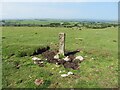
Neolithic and Bronze AgeSite Name: Trehudreth Downs BCountry: England County: Cornwall Type: Standing Stone (Menhir)
Nearest Town: Bodmin Nearest Village: Blisland
Map Ref: SX12597292
Latitude: 50.525973N Longitude: 4.645426W
Condition:
| 5 | Perfect |
| 4 | Almost Perfect |
| 3 | Reasonable but with some damage |
| 2 | Ruined but still recognisable as an ancient site |
| 1 | Pretty much destroyed, possibly visible as crop marks |
| 0 | No data. |
| -1 | Completely destroyed |
| 5 | Superb |
| 4 | Good |
| 3 | Ordinary |
| 2 | Not Good |
| 1 | Awful |
| 0 | No data. |
| 5 | Can be driven to, probably with disabled access |
| 4 | Short walk on a footpath |
| 3 | Requiring a bit more of a walk |
| 2 | A long walk |
| 1 | In the middle of nowhere, a nightmare to find |
| 0 | No data. |
| 5 | co-ordinates taken by GPS or official recorded co-ordinates |
| 4 | co-ordinates scaled from a detailed map |
| 3 | co-ordinates scaled from a bad map |
| 2 | co-ordinates of the nearest village |
| 1 | co-ordinates of the nearest town |
| 0 | no data |
Internal Links:
External Links:
I have visited· I would like to visit
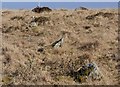
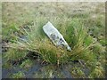
TheCaptain visited on 18th Jun 2022 - their rating: Cond: 2 Amb: 3 Access: 3 In about what should be the middle of the stone row, past the cows and further on I find a sort of stone setting, which I think is what I have called Trehudreth Downs B stone setting. There is a sort of standing stone stump, with a few other bits arranged in a square around it, and is certainly not natural. Once home, looking in my Bodmin Moor survey, and I find it is included as a stone setting in there.
")
See Historic England Monument Number 433992. Trehudreth Downs - Possible stone setting.
and Historic England HER Number 3619. Trehudreth Downs - Neolithic standing stone.
There is a standing stone stump, with a few other bits arranged in a square around it, and is certainly not natural.
You may be viewing yesterday's version of this page. To see the most up to date information please register for a free account.
")
")
")
")
Do not use the above information on other web sites or publications without permission of the contributor.
Nearby Images from Geograph Britain and Ireland:
©2020(licence)
©2020(licence)
©2021(licence)
©2021(licence)
©2021(licence)
The above images may not be of the site on this page, they are loaded from Geograph.
Please Submit an Image of this site or go out and take one for us!
Click here to see more info for this site
Nearby sites
Key: Red: member's photo, Blue: 3rd party photo, Yellow: other image, Green: no photo - please go there and take one, Grey: site destroyed
Download sites to:
KML (Google Earth)
GPX (GPS waypoints)
CSV (Garmin/Navman)
CSV (Excel)
To unlock full downloads you need to sign up as a Contributory Member. Otherwise downloads are limited to 50 sites.
Turn off the page maps and other distractions
Nearby sites listing. In the following links * = Image available
102m ESE 121° Trehudreth Downs East* Cairn (SX1267672864)
143m W 280° Trehudreth Downs row* Stone Row / Alignment (SX12457295)
192m SSW 201° Trehudreth Downs C* Standing Stones (SX1251672743)
194m SW 233° Trehudreth Downs A* Standing Stone (Menhir) (SX12437281)
206m SSW 212° Trehudreth Downs West* Cairn (SX1247572749)
339m SW 223° Trehudreth Downs SW Cairns* Cairn (SX12357268)
390m E 84° Greenbarrow Downs* Barrow Cemetery (SX12987295)
695m S 185° Peverell's Cross* Ancient Cross (SX1250472230)
1.1km SSE 166° Cardinham Moor row* Stone Row / Alignment (SX12827187)
1.4km NNE 14° Manor Common South* Cairn (SX1297174241)
1.4km N 11° Manor Common North* Cairn (SX1292074331)
1.8km SSE 161° Cardinham Moor stone* Standing Stone (Menhir) (SX131712)
1.9km SSE 167° Cardinham Moor Cairn Ring Cairn (SX12967109)
2.2km NNE 12° Trippet Stones* Stone Circle (SX13117501)
2.2km W 273° St Pratt's Well* Holy Well or Sacred Spring (SX1037973100)
2.4km N 356° Arthur's Sword* Natural Stone / Erratic / Other Natural Feature (SX12527537)
2.6km NNW 330° Kerrow Downs* Ancient Village or Settlement (SX114752)
2.6km W 270° Blisland Holy Well* Holy Well or Sacred Spring (SX1073)
2.6km N 7° Carbilly Cairn* Cairn (SX130755)
2.7km W 275° Blisland Millennium Stone* Modern Stone Circle etc (SX09947324)
2.9km NE 35° Stripple Stones* Stone Circle (SX14357521)
2.9km W 272° Holy Well (Blisland)* Holy Well or Sacred Spring (SX097731)
3.0km N 2° Carbilly Farmstead Ancient Village or Settlement (SX128759)
3.0km NNW 349° Bradford Hut Circles Ancient Village or Settlement (SX121759)
3.1km E 83° Blacktor Settlement* Ancient Village or Settlement (SX157732)
View more nearby sites and additional images


 We would like to know more about this location. Please feel free to add a brief description and any relevant information in your own language.
 Wir möchten mehr über diese Stätte erfahren. Bitte zögern Sie nicht, eine kurze Beschreibung und relevante Informationen in Deutsch hinzuzufügen.
 Nous aimerions en savoir encore un peu sur les lieux. S'il vous plaît n'hesitez pas à ajouter une courte description et tous les renseignements pertinents dans votre propre langue.
 Quisieramos informarnos un poco más de las lugares. No dude en añadir una breve descripción y otros datos relevantes en su propio idioma.