


<< Our Photo Pages >> Dinas Mawr, Pwllderi, Pencaer - Promontory Fort / Cliff Castle in Wales in Pembrokeshire
Submitted by h_fenton on Wednesday, 06 February 2008 Page Views: 13353
Iron Age and Later PrehistorySite Name: Dinas Mawr, Pwllderi, PencaerCountry: Wales County: Pembrokeshire Type: Promontory Fort / Cliff Castle
Nearest Town: Fishguard Nearest Village: Pencaer
Map Ref: SM88803869
Latitude: 52.006358N Longitude: 5.078565W
Condition:
| 5 | Perfect |
| 4 | Almost Perfect |
| 3 | Reasonable but with some damage |
| 2 | Ruined but still recognisable as an ancient site |
| 1 | Pretty much destroyed, possibly visible as crop marks |
| 0 | No data. |
| -1 | Completely destroyed |
| 5 | Superb |
| 4 | Good |
| 3 | Ordinary |
| 2 | Not Good |
| 1 | Awful |
| 0 | No data. |
| 5 | Can be driven to, probably with disabled access |
| 4 | Short walk on a footpath |
| 3 | Requiring a bit more of a walk |
| 2 | A long walk |
| 1 | In the middle of nowhere, a nightmare to find |
| 0 | No data. |
| 5 | co-ordinates taken by GPS or official recorded co-ordinates |
| 4 | co-ordinates scaled from a detailed map |
| 3 | co-ordinates scaled from a bad map |
| 2 | co-ordinates of the nearest village |
| 1 | co-ordinates of the nearest town |
| 0 | no data |
Internal Links:
External Links:
I have visited· I would like to visit
h_fenton has visited here
")
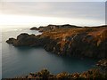
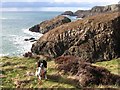
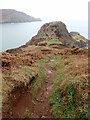
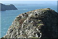
Dinas Mawr, Pwllderi, Pen-caer
Promontory fort, Two lines of ramparts and ditches, the promontory is quite small and very craggy the only potential space for settlement would be immediatly inside the fortifications, there is at least one hut circle, possibly more.
RCAHMW suggest this may be ritual or ceremonial site comparable with the site of 'La Pinnacle' on Jersey. See this link
You may be viewing yesterday's version of this page. To see the most up to date information please register for a free account.
")
")
")
")
")
Do not use the above information on other web sites or publications without permission of the contributor.
Nearby Images from Geograph Britain and Ireland:
©2011(licence)
©2016(licence)

©2015(licence)
©2022(licence)
©2023(licence)
The above images may not be of the site on this page, they are loaded from Geograph.
Please Submit an Image of this site or go out and take one for us!
Click here to see more info for this site
Nearby sites
Key: Red: member's photo, Blue: 3rd party photo, Yellow: other image, Green: no photo - please go there and take one, Grey: site destroyed
Download sites to:
KML (Google Earth)
GPX (GPS waypoints)
CSV (Garmin/Navman)
CSV (Excel)
To unlock full downloads you need to sign up as a Contributory Member. Otherwise downloads are limited to 50 sites.
Turn off the page maps and other distractions
Nearby sites listing. In the following links * = Image available
547m ENE 72° Tal-y-Gaer Farm Stone Chamber* Ancient Village or Settlement (SM8932938835)
818m ENE 78° Garn Fawr (Pembrokeshire)* Hillfort (SM89613882)
818m E 90° Ysgubor Gaer* Hillfort (SM89623865)
1.3km ENE 77° Garn Fechan* Hillfort (SM90043893)
1.3km SE 134° Castell Poeth Ancient Village or Settlement (SM89723773)
2.1km ENE 73° Garn Gilfach Standing Stone* Standing Stone (Menhir) (SM90803920)
2.1km SSE 167° Castell Bach (Pencaer) Hillfort (SM89193666)
2.1km E 85° Gilfach Farm Standing Stone* Standing Stone (Menhir) (SM90873880)
2.1km E 79° Garn Gilfach.* Chambered Cairn (SM909390)
2.7km ENE 68° Trenewydd well* Holy Well or Sacred Spring (SM913396)
3.3km SSE 155° St Nicholas Stones* Early Christian Sculptured Stone (SM901356)
3.3km SSE 155° St Nicholas Well (N Pembrokeshire)* Holy Well or Sacred Spring (SM901356)
3.7km ESE 118° Ffynnondruidion* Chambered Tomb (SM920368)
4.0km ESE 121° Fynnon Drudion* Standing Stone (Menhir) (SM921365)
4.1km SE 140° Rhos y Clegyrn* Stone Circle (SM9133035456)
4.2km SSE 152° Ffyst Samson* Chambered Tomb (SM90613491)
4.3km SSW 199° Castell Coch (Abercastle)* Promontory Fort / Cliff Castle (SM87243465)
4.4km ENE 77° Ffynnon Wnda* Holy Well or Sacred Spring (SM9317939536)
4.5km E 83° Carn Wnda Standing Stone* Standing Stone (Menhir) (SM9327239010)
4.5km ENE 76° St Gwyndaf Stones* Early Christian Sculptured Stone (SM932396)
4.5km E 81° Carn Wnda.* Chambered Tomb (SM93313923)
4.8km SE 128° Penmeiddyn Stone Row / Alignment (SM9241535584)
4.9km E 82° Llanwnda Cemetery Crossroads stone* Early Christian Sculptured Stone (SM93683919)
5.2km ESE 119° Manorowen* Standing Stone (Menhir) (SM9324736021)
5.4km E 84° Parc-y-Cromlech* Chambered Tomb (SM94223907)
View more nearby sites and additional images


 We would like to know more about this location. Please feel free to add a brief description and any relevant information in your own language.
 Wir möchten mehr über diese Stätte erfahren. Bitte zögern Sie nicht, eine kurze Beschreibung und relevante Informationen in Deutsch hinzuzufügen.
 Nous aimerions en savoir encore un peu sur les lieux. S'il vous plaît n'hesitez pas à ajouter une courte description et tous les renseignements pertinents dans votre propre langue.
 Quisieramos informarnos un poco más de las lugares. No dude en añadir una breve descripción y otros datos relevantes en su propio idioma.